Pabbo

Last updated
Pabbo
Municipality
Pabbo Town council formerly IDP Camp.jpg
Uganda location map.svg
Red pog.svg
Pabbo
Location in Uganda
Coordinates: 03°00′00″N32°08′42″E / 3.00000°N 32.14500°E / 3.00000; 32.14500
Country Flag of Uganda.svg Uganda
Region Northern Region of Uganda
Sub-region Acholi sub-region
Districts of Uganda Amuru District
Elevation
3,150 ft (960 m)

Pabbo, sometimes spelled as Pabo,[ citation needed ] is a municipality in Amuru District of the Northern Region of Uganda.

Contents

Location

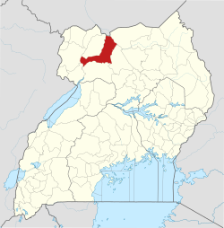
Pabbo is on the Gulu-Nimule Road, the main highway (A-104) between Gulu and the border with Southern Sudan at Nimule. Pabbo is approximately 39 kilometres (24 mi), by road, north of Gulu, the largest city in the Acholi sub-region. [1] Its location is approximately 375 kilometres (233 mi), by road, north of Kampala, the capital and largest city of Uganda. [2] The coordinates of the town are 03 00 00N, 32 08 42E (Latitude:3.0000; Longitude:32.1450). [3]

Overview

During the Lord's Resistance Army war (1986 - 2006), Pabbo was the site of one of the largest camps for internally displaced people, swelling to over 67,000 in 2005. [4] Since the cessation of hostilities in 2006, some of those people have returned to their villages. [5] [6]

Points of interest

The following points of interest lie within the town limits or close to its edges:

See also

Related Research Articles

<span class="mw-page-title-main">Gulu District</span> Neucleated District in Northern Region of Uganda, Uganda

Gulu is a district in the Northern Region of Uganda. The regional headquarters are located in the city of Gulu, which is also the administrative capital of Northern Uganda. the district consists of two main divisions, Gulu West and Gulu East.

<span class="mw-page-title-main">Kitgum District</span> District in Northern Uganda, Uganda

Kitgum District is a district in Northern Uganda. It is named after its major town of Kitgum, where the district headquarters is located. It has suffered many deaths and social disruption resulting from the 20-year civil war within the region during the late 20th century. The government moved tens of thousands of residents to internally displaced persons camps for their protection, where they were subject to raids by the rebels and also harsh conditions, including disease.

<span class="mw-page-title-main">St. Mary's Hospital Lacor</span> Private community hospital in Uganda

St. Mary's Hospital Lacor, commonly referred to as Lacor Hospital, is a hospital in Gulu District, Northern Uganda. It was founded by Comboni Missionaries and is administered and managed by Roman Catholic Archdiocese of Gulu.

Atiak is a town in the Northern Region of Uganda on the Gulu-Nimule Road, the primary trade route between Uganda and South Sudan.

<span class="mw-page-title-main">Patongo, Uganda</span> Place in Northern Region of Uganda, Uganda

Patongo is a town in Agago District, Acholi sub-region in the Northern Region of Uganda. The town is administered by Patongo Town Council

Anaka is a town in the Northern Region of Uganda. It is the site of the Nwoya District headquarters.

Gulu–Nimule Road is a road in the Northern Region of Uganda, connecting the city of Gulu in Gulu District and the town of Nimule in Eastern Equatoria State in South Sudan, just north of the international border between the two countries. The road, known as Highway A104 in Uganda, continues into South Sudan as Highway A43.

Karuma Falls is a town in Uganda.

Nwoya is a town in Nwoya District in the Acholi sub-region, in the Northern Region of Uganda. It is the main municipal, administrative, and commercial centre of the district. Nwoya Town Council is classified as a municipality.

Bibia is a municipality in the Amuru District of the Northern Region of Uganda.

Adilang is a town in the Northern Region of Uganda.

Amuru is a town in the Northern Region of Uganda. It is the main municipal, administrative, and commercial centre of Amuru District.

The Acholibur–Gulu–Olwiyo Road is a road in the Northern Region of Uganda, connecting the town of Acholibur to the city of Gulu and the town of Olwiyo.

Olwiyo is a town in Nwoya District in the Northern Region of Uganda.

Elegu is a town in the Northern Region of Uganda. It sits across the international border from the town of Nimule, South Sudan.

The Kamdini–Gulu Road, also known as the Gulu–Kamdini Road, is a road in the Northern Region of Uganda, connecting the town of Kamdini with Gulu, the largest city in the Northern Region.

Bobi is a town in the Northern Region of Uganda.

Omoro District is a district in the Northern Region of Uganda.

Palenga is a town in the Omoro District in the Northern Region of Uganda. It is the site of the district headquarters.

The Kampala–Gulu Highway, also Kampala–Gulu Road, is a road connecting the capital city of Kampala, in the Central Region, with the city of Gulu, the largest urban centre in the Northern Region of Uganda.

References

  1. GFC. "Road Distance Between Pabbo And Gulu With Map". Globefeed.com (GFC). Retrieved 23 July 2015.
  2. GFC. "Road Distance Between Pabbo And Kampala With Map". Globefeed.com (GFC). Retrieved 23 July 2015.
  3. Google (23 July 2015). "Location of Pabbo At Google Maps" (Map). Google Maps . Google. Retrieved 23 July 2015.
  4. UNICEF (15 June 2005). "Study Highlights Rape In Northern Uganda's Largest IDP Camp". United Nations Children’s Fund (UNICEF). Retrieved 23 July 2015.
  5. Jaramogi, Patrick (19 April 2006). "10,000 Leave Pabbo Camp". New Vision . Kampala. Archived from the original on 23 July 2015. Retrieved 23 July 2015.
  6. Klein, Alice (24 January 2012). "Northern Uganda's Displaced People Are Left To Fend For Themselves". The Guardian . London. Retrieved 23 July 2015.
  7. Jeff Lule, and Cecilia Okoth (28 March 2010). "Japan And World Bank Will Finance Upgrade of Gulu-Nimule Road". New Vision . Kampala. Archived from the original on 3 September 2014. Retrieved 23 July 2015.

03°00′00″N32°08′42″E / 3.00000°N 32.14500°E / 3.00000; 32.14500