
Yolo County, officially the County of Yolo, is a county located in the northern portion of the U.S. state of California. As of the 2010 census, the population was 200,849. Its county seat is Woodland.

Imperial County is a county in the U.S. state of California. As of the 2010 census, the population was 174,528. The county seat is El Centro. Established in 1907 from a division of San Diego County, it was last county to be formed in California.
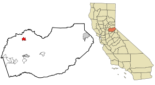
Colusa is the county seat of Colusa County, California. The population was 5,971 at the 2010 census, up from 5,402 at the 2000 census. Colusi originates from the local Coru Native American tribe, who in the 1840s lived on the opposite side of the Sacramento River.
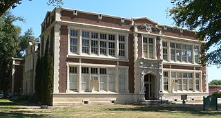
Georgetown is a census-designated place (CDP) in El Dorado County, California. It is the northeastern-most town in the California Mother Lode. The population was 2,367 at the 2010 census, up from 962 in 2000. The town is registered as California Historical Landmark #484.

Mendota is a U.S. city in Fresno County, California. The population was 11,014 at the 2010 U.S. Census. The State Routes 180 and 33 run through the agricultural city. Mendota is located 8.5 miles (14 km) south-southeast of Firebaugh, at an elevation of 174 feet.

Willows is a city in and the county seat of Glenn County, California. The city is a home to regional government offices, including the California Highway Patrol, California Department of Motor Vehicles, the United States Bureau of Reclamation and the main offices of the Mendocino National Forest, which comprises about one million acres of Federal land located mostly in mountainous terrain west of Willows. The population was 6,166 at the 2010 census, down from 6,220 at the 2000 census.

Calexico is a city in Imperial County, California. The population was 38,572 at the 2010 census, up from 27,109 at the 2000 census. Calexico is about 122 miles (196 km) east of San Diego and 62 miles (100 km) west of Yuma, Arizona. The name of the city is a portmanteau of California and Mexico, which, like that of its adjacent sister city of Mexicali, emphasizes its identity as a border city.

Wasco is a city in the San Joaquin Valley, in Kern County, California, United States. Wasco is located 24 miles (39 km) northwest of Bakersfield, at an elevation of 328 feet (100 m). The population was 25,545 at the 2010 census, up from 21,263 at the 2000 census.

Clearlake is a city in Lake County, California, United States. Clearlake is 4.5 miles (7.2 km) north-northwest of Lower Lake, at an elevation of 1417 feet (432 m). As of the 2010 census, the city had a total population of 15,250, up from 13,142 in 2000. It takes its name from Clear Lake.

Camp Eighteen is an unincorporated community in Butte County, California, about 1.25 miles (2.01 km) from the Plumas County line. It lies 7 miles (11 km) north of Clipper Mills, at an elevation of 3947 feet. The ZIP Code is 95940. The community is inside area code 530. Nearby communities are Lumpkin and Rogerville. The now-defunct Feather River Railway used to serve the area but appears to have been decommissioned. Sly Creek Reservoir is about 3.6 miles (5.8 km) southeast.

Enterprise is a former settlement in Butte County, California. It was located 5 miles (8.0 km) west-northwest of Forbestown on the South Fork of the Feather River, at an elevation of 902 feet. In 1968, it was inundated by Lake Oroville.
Diamondville is a former settlement in Butte County, California, United States. It was located 4 miles (6.4 km) west of Paradise. The town was named for James Diamond. In the 1870s, Diamondville was on the stage coach route to Chico, 11 miles (18 km) distant; fares averaged 10 cents per mile. Cretaceous fossils were reported to be found from Butte Creek below Diamondville. In an 1884 report published by the United States government on the production of precious metals in the United States, Diamondville was described as "an old mining town. .. occupied by one or two ranchers and only mined by Chinese."
Eric is a settlement in Kern County, California with a population of 14, as of the 2012 census. It is located on the railroad 7 miles (11 km) east of Tehachapi, at an elevation of 3924 feet.
Harpertown is an unincorporated community in Kern County, California. It is located on the railroad 7 miles (11 km) southeast of downtown Bakersfield, at an elevation of 397 feet (121 m).
Kyan is a former settlement in Kern County, California. It was located on the Sunset Railroad 11.5 miles (19 km) east of Taft, at an elevation of 335 feet. Kyan still appeared on maps as of 1932.
Packwood is a former settlement in Kern County, California. It was located 11 miles (18 km) south-southeast of Orchard Peak, at an elevation of 1375 feet. Packwood still appeared on maps as of 1947.
Ribier is an unincorporated community in Kern County, California. It is located on the railroad 11 miles (18 km) southeast of Bakersfield, at an elevation of 446 feet (136 m).
Sand Canyon is an unincorporated community in Kern County, California. It is located on Cache Creek 7 miles (11 km) east of Tehachapi, at an elevation of 4,500 feet (1,400 m).
Stevens is an unincorporated community in Kern County, California. It is located on the Southern Pacific Railroad 11.5 miles (19 km) west-northwest of Bakersfield, at an elevation of 341 feet (104 m).
Ivy is a former settlement in Modoc County, California. It was located on the stage coach line about midway between Eagleville and Likely, California at 16 miles (26 km) east of Likely by road.


