
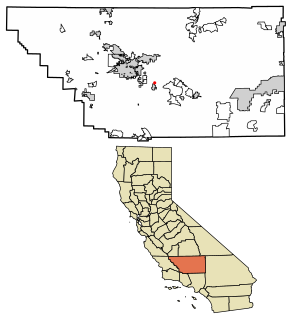
Wawona is a census-designated place in Mariposa County, California. It is located 18 miles (29 km) east of Mariposa, at an elevation of 3999 feet. The population was 169 at the 2010 census.

Campo is a census-designated place (CDP) located in the Mountain Empire area of southeastern San Diego County, California. The population was 2,684 at the 2010 census.
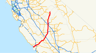
State Route 41 is a state highway in the U.S. state of California, connecting the Cabrillo Highway in Morro Bay with Fresno and Yosemite National Park via the San Joaquin Valley. It has been constructed as an expressway from near SR 198 in Lemoore north to the south part of Fresno, where the Yosemite Freeway begins, passing along the east side of downtown and extending north into Madera County.

The Wawona Hotel is a historic hotel located within southern Yosemite National Park, in California. It was declared a National Historic Landmark in 1987, and is on the National Register of Historic Places. On March 1, 2016, the Wawona Hotel was renamed Big Trees Lodge due to a legal dispute between the US Government, which owns the property, and the outgoing concessionaire, Delaware North, which claims rights to the trademarked name.

Badger Pass Ski Area is a small ski area located within Yosemite National Park. Badger Pass is one of only three lift serviced ski areas operating in a US National Park. It is situated five miles (8 km) south-southeast of the Chinquapin intersection of Wawona Road with Glacier Point Road in the southern area of Yosemite National Park. Glacier Point Road provides the access to this ski area. During high snow level and/or ski season, Glacier Point road terminates at Badger Pass ski Resort. Under these conditions, the remainder of Glacier Point Road is used for cross-country skiing access to Glacier Point and other destinations in the high country.

Cohasset is a census-designated place in Butte County, California, United States, approximately 17.7 miles (28.5 km) NNE of Chico, California. Its main street is named Cohasset Road, which comes from the Algonquian Indian language and means "long rocky place". The population was 847 at the 2010 census.

Fieldbrook is a census-designated place in Humboldt County, California. It is located 7 miles (11 km) north-northeast of Arcata, at an elevation of 203 feet (62 m). The population was 859 at the 2010 census.

Yosemite West is an unincorporated community of resort homes located just outside the southern area of Yosemite National Park, just off Wawona Road, a continuation of State Route 41 from Fresno. It is situated one mile (1.6 km) south of the Chinquapin intersection of Wawona Road with Glacier Point Road at an altitude of 5,100–6,300 ft (1,600–1,900 m). The elevation reported by the USGS is 5,866 feet (1,788 m). The community is part of Henness Ridge, nearly 3,000 feet (910 m) above the southern banks of the Merced River and State Route 140 from Mariposa.

Lockwood is a census-designated place in Monterey County, California. It is 6 miles (9.7 km) east-southeast of Jolon, 1.8 miles (2.9 km) north of the mouth of Tule Canyon, 3.0 miles (4.8 km) north of San Antonio River, and 9.3 miles (15.0 km) north of Bryson, at an elevation of 971 feet (296 m).

Dobbins is a census-designated place in Yuba County, California.

Sunnyside is a census-designated place in Fresno County, California. It is located on the Southern Pacific Railroad 5 miles (8 km) north-northeast of Malaga, at an elevation of 328 ft (100 m). At the 2010 census, Sunnyside's population was 4,235.
Edmundson Acres is a census-designated place in Kern County, California. It is located 1.25 miles (2 km) north-northeast of Arvin, at an elevation of 486 feet (148 m). Edmundson Acres' ZIP code is 93203. The population was 279 at the 2010 census.
South Wawona is an unincorporated community in Mariposa County, California. It is located 1 mile (1.6 km) east-northeast of Wawona and 0.5 miles (0.8 km) south of North Wawona, at an elevation of 4101 feet.

DeHaven is an unincorporated community in Mendocino County, California. It is located on California State Route 1 near the Pacific coast 1.5 miles (2.4 km) north of Westport, at an elevation of 46 feet.
Ramsey is an unincorporated community in Mendocino County, California. It is located on the Eel River and Northwestern Pacific Railroad 6.5 miles (10 km) north of Spyrock, at an elevation of 686 feet.

Chinquapin is a former settlement in Mariposa County, California. It was located 8.5 miles (14 km) north-northwest of Wawona. It is located within Yosemite National Park, adjacent to the community of Yosemite West. Chinquapin is the midway point between Yosemite Valley and Wawona, a community inside the park.
Elevenmile is a former settlement in Mariposa County, California. It was located 1 mile (1.6 km) south-southeast of Chinquapin and 11 miles (18 km) from Wawona.

The South Fork Merced River is the largest tributary of the Merced River. Most of the river flows within Yosemite National Park in the Sierra Nevada of California. The river is 43 miles (69 km) long, and its drainage basin covers about 240 square miles (620 km2), of which 109 square miles (280 km2) are in the national park. The average flow at the mouth is 356 cubic feet per second (10.1 m3/s).
Ramsey Crossing is an unincorporated community in Placer County, California. Ramsey Crossing is located in Long Canyon, 2.5 miles (4.0 km) north of Devil Peak. It lies at an elevation of 3681 feet.


