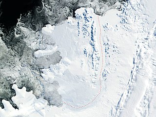
Alexander Island, which is also known as Alexander I Island, Alexander I Land, Alexander Land, Alexander I Archipelago, and Zemlja Alexandra I, is the largest island of Antarctica. It lies in the Bellingshausen Sea west of Palmer Land, Antarctic Peninsula from which it is separated by Marguerite Bay and George VI Sound. The George VI Ice Shelf entirely fills George VI Sound and connects Alexander Island to Palmer Land. The island partly surrounds Wilkins Sound, which lies to its west. Alexander Island is about 390 kilometres (240 mi) long in a north–south direction, 80 kilometres (50 mi) wide in the north, and 240 kilometres (150 mi) wide in the south. Alexander Island is the second-largest uninhabited island in the world, after Devon Island.
The LeMay Range is a mountain range 40 nautical miles (70 km) long with peaks rising to 2,000 metres (6,600 ft), extending in a northwest–southeast direction from Snick Pass to the north side of Uranus Glacier in the central portion of Alexander Island, Antarctica. It was first seen from the air by Lincoln Ellsworth on November 23, 1935, and the north and east portions mapped from photos obtained on that flight by W.L.G. Joerg. Later, it was resighted from the air by the Ronne Antarctic Research Expedition (RARE), 1947–48, and named by Finn Ronne for General Curtis LeMay, Deputy Chief of Air Staff for Research and Development of the then United States Army Air Forces, which furnished equipment for the expedition. The range was remapped in detail from RARE photos by D. Searle of the Falkland Islands Dependencies Survey in 1960.
Sibelius Glacier is a glacier, 12 miles (19 km) long and 6 miles (10 km) wide, flowing south into the Mozart Ice Piedmont 10 miles (16 km) southwest of Mount Stephenson in the northern portion of Alexander Island, Antarctica. The glacier was first sighted from the air by the British Graham Land Expedition in 1937. Mapped from air photos taken by the Ronne Antarctic Research Expedition in 1947–48, by Searle of the Falkland Islands Dependencies Survey in 1960. This feature was named by the United Kingdom Antarctic Place-Names Committee for Jean Sibelius (1865-1957), Finnish composer.
The Enceladus Nunataks are a group of about eight nunataks scattered over a wide area at the head of the drainage basin of Saturn Glacier, in southern Alexander Island, Antarctica. They were mapped from trimetrogon air photography taken by the Ronne Antarctic Research Expedition, 1947–48, and from survey by the Falkland Islands Dependencies Survey, 1948–50. The group was named by the UK Antarctic Place-Names Committee from association with Saturn Glacier, Enceladus being one of the moons of the planet Saturn.
Enigma Peak is a peak, 1,500 metres (4,900 ft) high, surmounting Fournier Ridge in the Desko Mountains, on Rothschild Island in Antarctica. It was probably seen from a distance by F. Bellingshausen in 1821, Jean-Baptiste Charcot in 1909, and the British Graham Land Expedition in 1936. It was observed and photographed from the air by the U.S. Antarctic Service, 1939–41, and was mapped as the prominent northwestern peak of the island. It was mapped in greater detail from air photos taken by the Ronne Antarctic Research Expedition, 1947–48, by D. Searle of the Falkland Islands Dependencies Survey in 1960, and from U.S. Landsat imagery of February 1975. It was so named by the UK Antarctic Place-Names Committee because of difficulty in identifying the peak during the map compilation.
Bartók Glacier is a glacier, 7 nautical miles (13 km) long and 3 nautical miles (6 km) wide, flowing southwest from the southern end of the Elgar Uplands in the northern part of Alexander Island. It was first photographed from the air and roughly mapped by the British Graham Land Expedition in 1937, and more accurately mapped from air photos taken by the Ronne Antarctic Research Expedition, 1947–48, by D. Searle of the Falkland Islands Dependencies Survey in 1960. It was named by the UK Antarctic Place-Names Committee after the Hungarian composer Béla Bartók.
Mount Calais is a massive mountain, 2,360 metres (7,700 ft) high, at the northwest side of Schokalsky Bay in the northeast part of Alexander Island, Antarctica. It was first roughly surveyed in 1909 by the French Antarctic Expedition under Jean-Baptiste Charcot, who named it for the French city of Calais. The mountain was resurveyed in 1948 by the Falkland Islands Dependencies Survey. Mount Calais is the eighth-highest point of Alexander Island while Mount Stephenson remains the highest of all the peaks.
Clemence Massif is an elongated, mostly ice-free massif, 15 nautical miles (28 km) long and rising to 1,274 metres (4,180 ft), standing 30 nautical miles (56 km) southeast of Shaw Massif on the east side of Lambert Glacier. It was discovered by Australian National Antarctic Research Expeditions personnel from Beaver aircraft piloted by Flying Officer D.M. Johnston, Royal Australian Air Force (RAAF), in 1957, and named by the Antarctic Names Committee of Australia for Squadron Leader P.H. Clemence, who commanded the RAAF Antarctic Flight at Mawson Station in 1957.
The Colbert Mountains are a group of isolated mountains with several rounded snow-covered summits, the highest at 2,095 metres (6,873 ft), overlooking Handel Ice Piedmont between Haydn Inlet and Schubert Inlet in the west central part of Alexander Island. It was first seen and photographed from a distance by Lincoln Ellsworth on his trans-Antarctic flight of November 23, 1935, and partially mapped from these photos by W.L.G. Joerg. It was resighted and photographed from the air by the United States Antarctic Service, 1939–41, and by the Ronne Antarctic Research Expedition (RARE) of 1947–1948, under Finn Ronne, who named it for R. Admiral Leo O. Colbert, head of the United States Coast and Geodetic Survey, which furnished equipment for the expedition. It was remapped in detail from RARE air photos by D. Searle of the Falkland Islands Dependencies Survey in 1960.
Nichols Snowfield is a snowfield, 22 nautical miles (41 km) long and 8 nautical miles (15 km) wide, bounded by the Rouen Mountains and Elgar Uplands to the east and Lassus Mountains to the west, in the north part of Alexander Island, Antarctica. The snowfield was first sighted from the air and roughly mapped by the British Graham Land Expedition (BGLE) in 1937. Mapped in detail from air photos taken by the Ronne Antarctic Research Expedition (RARE), 1947–48, by Searle of the Falkland Islands Dependencies Survey (FIDS) in 1960. It is named by the RARE for Dr. Robert L. Nichols, head of the Department of Geology, Tufts University, and senior scientist of the Ronne expedition.
Delius Glacier is a glacier, 6 nautical miles (11 km) long and 2 nautical miles (4 km) wide, flowing west from the Elgar Uplands into Nichols Snowfield, in the northern part of Alexander Island, Antarctica. It was first seen from the air and roughly mapped by the British Graham Land Expedition in 1937. It was more accurately mapped from air photos taken by the Ronne Antarctic Research Expedition, 1947–48, by D. Searle of the Falkland Islands Dependencies Survey in 1960, and from U.S. Landsat imagery of February 1975. It was named by the UK Antarctic Place-Names Committee after Frederick Delius, the British composer.
Sullivan Glacier is a glacier flowing west into Gilbert Glacier, immediately south of Elgar Uplands in the north part of Alexander Island, Antarctica. The glacier was first sighted from a distance by the British Graham Land Expedition during a flight in 1937 and roughly mapped. Remapped from air photos taken by the Ronne Antarctic Research Expedition in 1947–48, by Searle of the Falkland Islands Dependencies Survey in 1960. In association with the names of other composers in this area, named by United Kingdom Antarctic Place-Names Committee after Sir Arthur Sullivan (1842–1900), English composer.
Pearson Spur is a spur extending southeast from Elgar Uplands toward the head of Sibelius Glacier, situated in the northern portion of Alexander Island, Antarctica. Photographed from the air by Ronne Antarctic Research Expedition (RARE) in 1947, roughly mapped from air photographs by Falkland Islands Dependencies Survey (FIDS) in 1959, and surveyed by British Antarctic Survey (BAS), 1973–77. Named by United Kingdom Antarctic Place-Names Committee (UK-APC) in 1980 after Martin Robert Pearson, BAS glaciologist, 1970–73, who worked on Alexander Island, in years 1971 and 1972.

Matusevich Glacier is a broad glacier about 50 nautical miles long, with a well developed glacier tongue, flowing to the coast of East Antarctica between the Lazarev Mountains and the northwestern extremity of the Wilson Hills.
Pearson Spur is a spur extending southeast from Elgar Uplands toward the head of Sibelius Glacier, situated in the northern portion of Alexander Island, Antarctica. Photographed from the air by Ronne Antarctic Research Expedition (RARE) in 1947, roughly mapped from air photographs by Falkland Islands Dependencies Survey (FIDS) in 1959, and surveyed by British Antarctic Survey (BAS), 1973–77. Named by United Kingdom Antarctic Place-Names Committee (UK-APC) in 1980 after Martin Robert Pearson, BAS glaciologist, 1970–73, who worked on Alexander Island, in years 1971 and 1972.
The Gannon Nunataks are a notable twin-peaked group of nunataks and several smaller rock outcrops, located between the northern end of the LeMay Range and the Lully Foothills, situated in the west-central portion of Alexander Island, Antarctica. The feature was photographed from the air by the Ronne Antarctic Research Expedition, 1947–48, and mapped from these photographs by D. Searle of the Falkland Islands Dependencies Survey, 1960. It was named in 1977 by the UK Antarctic Place-Names Committee for Anthony E. Gannon, a British Antarctic Survey meteorological observer at Halley Station, 1970–72, a general assistant at Grytviken, 1972, and a builder at Stonington Island, 1973–75, who participated in a plane-table survey of northern Alexander Island, 1973.
Gerontius Glacier is a glacier flowing north from the Elgar Uplands into Tufts Pass in northern Alexander Island, Antarctica. It was so named by the UK Antarctic Place-Names Committee in 1977, association with the nearby uplands, from The Dream of Gerontius, a work for chorus, solo voices and orchestra by Edward Elgar. It is named after the oratorio The Dream of Gerontius by the British composer Edward Elgar from 1900.
The Gravier Peaks are prominent, ice-covered peaks, up to 2,120 metres (6,960 ft) high, situated 2 nautical miles (4 km) northeast of the Lewis Peaks on Arrowsmith Peninsula and extending in a northeast–southwest direction, on the west coast of Graham Land, Antarctica. They were first sighted and roughly positioned in 1903 by the French Antarctic Expedition under Jean-Baptiste Charcot, who named the feature for Charles Gravier, a French zoologist. They were surveyed in 1909 by the next French Antarctic Expedition under Charcot, at which time the individual peaks making up this group were first identified. The data for the present description is largely based upon a resurvey of the peaks in 1948 by the Falkland Islands Dependencies Survey.
Hansen Island is an island 6 nautical miles (11 km) long and 3 nautical miles (6 km) wide, lying immediately north of The Gullet at the head of Hanusse Bay, off the west coast of Graham Land, Antarctica. It was first surveyed in 1936 by the British Graham Land Expedition (BGLE) under John Rymill, who used the provisional name "North Island" for this feature. The island was resurveyed in 1948 by the Falkland Islands Dependencies Survey, and was renamed in 1954 by the UK Antarctic Place-Names Committee for Leganger H. Hansen, manager at Messrs. Christian Salvesen's whaling station at Leith Harbor, South Georgia, 1916–37, who gave great assistance to the BGLE, 1934–37.


