Elvira, Iowa

Last updated
Elvira, Iowa
USA Iowa location map.svg
Red pog.svg
Elvira, Iowa
Location within the state of Iowa
Coordinates: 41°51′32″N90°21′19″W / 41.85889°N 90.35528°W / 41.85889; -90.35528 Coordinates: 41°51′32″N90°21′19″W / 41.85889°N 90.35528°W / 41.85889; -90.35528
Country United States
State Iowa
County Clinton
Time zone UTC-6 (Central (CST))
  Summer (DST) UTC-5 (CDT)
ZIP codes
52732
Area code(s) 563

Elvira is an unincorporated community in Clinton County, Iowa, United States. It falls within the Clinton zip code (52732).

History

Elvira was platted in 1854. It was named by W. H. Gibbs, the owner of the town site, in honor of his wife. [1] Elvira's population was 31 in 1902, [2] and 37 in 1925. [3]

Related Research Articles

Canton, Iowa Unincorporated community in Iowa, United States

Canton is an unincorporated community in Jackson and Jones counties, Iowa, United States.

Dewar, Iowa Unincorporated town in Iowa, United States

Dewar is an unincorporated town in eastern Black Hawk County, Iowa, United States. It lies northeast of the city of Waterloo, the county seat of Black Hawk County. Its elevation is 889 feet (271 m). Although Dewar is unincorporated, it has a post office with the ZIP code of 50623, which opened on 25 October 1887.

Killduff, Iowa Unincorporated community in Iowa, United States

Killduff is an unincorporated community in southeastern Jasper County, Iowa, United States. It lies along local roads southeast of the city of Newton, the county seat of Jasper County.

Conroy, Iowa Census-designated place in Iowa, United States

Conroy is an unincorporated community and census-designated place (CDP) in central Iowa County, Iowa, United States. It lies along local roads southeast of the city of Marengo, the county seat of Iowa County. Its elevation is 879 feet (268 m). Conroy has a post office with the ZIP code of 52220, which opened on 5 January 1885. As of the 2010 census the population was 259.

Austinville, Iowa Unincorporated community in Iowa, United States

Austinville is an unincorporated community in southwestern Butler County, Iowa, United States. It lies along Iowa Highway 57 southwest of the city of Allison, the county seat of Butler County. Its elevation is 1,001 feet (305 m). Although Austinville is unincorporated, it has a post office with the ZIP code of 50608, which opened on 3 October 1892.

Prole, Iowa Unincorporated community in Iowa, United States

Prole is an unincorporated rural village in northwestern Warren County, Iowa, United States. It lies along Iowa Highway 28 northwest of the city of Indianola, the county seat of Warren County. Its elevation is 978 feet (298 m). Prole has a post office, with the ZIP code of 50229, a cafe, a floral shop and an auto repair shop by way of businesses and services.

Teeds Grove, Iowa Unincorporated community in Iowa, United States

Teeds Grove is an unincorporated community in northeastern Clinton County, Iowa, United States. It lies at the intersection of Clinton County Routes E44 and Z50, north of the city of Clinton, the county seat of Clinton County. Its elevation is 692 feet (211 m).
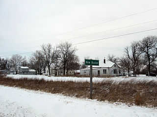
Folletts, Iowa unincorporated community in Iowa, United States

Folletts is an unincorporated community in Clinton County, Iowa, United States. It is located at the intersections of 292nd Street and County Highway Z36 on the north bank of the Wapsipinicon River. It is one mile west of Shaffton and three miles east of McCausland, at 41.750099N, -90.354990W.

Osborne, Iowa Unincorporated community in Iowa, United States

Osborne is an unincorporated community in Clayton County, Iowa, United States.

Barney, Iowa Unincorporated community in Iowa, United States

Barney is an unincorporated community in Madison County, Iowa, in the United States.

Maud, Iowa Unincorporated community in Iowa, United States

Maud is an unincorporated community in Allamakee County, Iowa, United States.

Malone, Iowa Unincorporated community in Iowa, United States

Malone is an unincorporated community in Clinton County, in the U.S. state of Iowa.

Petersville, Iowa Unincorporated community in Iowa, United States

Petersville is an unincorporated community in Clinton County, in the U.S. state of Iowa.

Olaf, Iowa Unincorporated community in Iowa, United States

Olaf is an unincorporated community in Wright County, Iowa, United States.

Watson, Iowa Unincorporated community in Iowa, United States

Watson is an unincorporated community in Clayton County, Iowa, United States. The county seat of Elkader lies approximately 15 miles to the southwest.

Turkey River, Iowa Unincorporated community in Iowa, United States

Turkey River is an unincorporated community in Clayton County, Iowa, United States. The community of Turkey River borders the Mississippi River, and the Turkey River. Turkey River also is situated on Iowa's border with Wisconsin.

Depew, Iowa Unincorporated community in Iowa, United States

Depew is an unincorporated community in Independence Township, Palo Alto County, Iowa, United States. Depew is located along county highways B20 and N60, 8.7 miles (14.0 km) northeast of Emmetsburg.

Douglas, Iowa unincorporated community in Iowa, United States

Douglas is an unincorporated community in Fayette County, Iowa, United States. It is located near the junction of County Road B44 and Maple Road, three miles southwest of Eldorado.

Verdi, Iowa Unincorporated community in Iowa, United States

Verdi is an unincorporated community in Washington County, Iowa, United States. It lies at the junction of Iowa Highway 1 and 290th Street.

Village Creek, Iowa Unincorporated community in Iowa, United States

Village Creek is an unincorporated community in Allamakee County, Iowa, United States.

References

  1. Wolfe, Patrick B. (1911). Wolfe's History of Clinton County, Iowa, Volume 1. B. F. Bowen. pp.  287–288.
  2. Cram's Modern Atlas: The New Unrivaled New Census Edition. J. R. Gray & Company. 1902. pp. 203–207.
  3. Company, Rand McNally and (1925). Premier Atlas of the World: Containing Maps of All Countries of the World, with the Most Recent Boundary Decisions, and Maps of All the States,territories, and Possessions of the United States with Population Figures from the Latest Official Census Reports, Also Data of Interest Concerning International and Domestic Political Questions. Rand McNally & Company. p. 190.