Petersville, Iowa

Last updated
Petersville, Iowa
Immaculate Conception Church - Petersville, Iowa.JPG
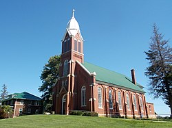
Immaculate Conception Catholic Church, Petersville
USA Iowa location map.svg
Red pog.svg
Petersville, Iowa
Coordinates: 41°58′03″N90°32′01″W / 41.96750°N 90.53361°W / 41.96750; -90.53361 Coordinates: 41°58′03″N90°32′01″W / 41.96750°N 90.53361°W / 41.96750; -90.53361
Country United States
State Iowa
County Clinton
Elevation
755 ft (230 m)
Time zone UTC-6 (Central (CST))
  Summer (DST) UTC-5 (CDT)
Area code(s) 563
GNIS feature ID464697 [1]

Petersville is an unincorporated community in Clinton County, in the U.S. state of Iowa. [1]

History

Petersville was originally called Quigley. [2] The present name honors John Peters and family, pioneer settlers. [2] The town was platted as Petersville in 1902. [3]

A post office was established under the name Quigley in 1883, and renamed Petersville in 1902; this post office closed in 1935. [4] [5]

Petersville's population was 55 in 1925. [6]

Related Research Articles

Honey Creek, Pottawattamie County, Iowa Unincorporated community in Iowa, United States

Honey Creek is an unincorporated community in Pottawattamie County, Iowa, United States. Its elevation is 1,014 feet (309 m). Although it is unincorporated, it has a ZIP code 51542.

Cedar, Iowa Unincorporated community in Iowa, United States

Cedar is an unincorporated community in southeastern Mahaska County, Iowa, United States. It lies along Iowa Highway 23 southeast of the city of Oskaloosa, the county seat of Mahaska County.

Sperry, Iowa Unincorporated community in Iowa, United States

Sperry is an unincorporated community in central Des Moines County, Iowa, United States. It lies along local roads north of the city of Burlington, the county seat of Des Moines County. Its elevation is 751 feet (229 m). Although Sperry is unincorporated, it has a post office with the ZIP code of 52650, which opened on 5 February 1870.

Teeds Grove, Iowa Unincorporated community in Iowa, United States

Teeds Grove is an unincorporated community in northeastern Clinton County, Iowa, United States. It lies at the intersection of Clinton County Routes E44 and Z50, north of the city of Clinton, the county seat of Clinton County. Its elevation is 692 feet (211 m).

Bryant, Iowa Unincorporated community in Iowa, United States

Bryant is an unincorporated community in northeastern Clinton County, Iowa, United States. It lies along local roads northwest of the city of Clinton, the county seat of Clinton County. Its elevation is 804 feet (245 m). Although Bryant is unincorporated, it has a post office, with the ZIP code of 52727, which opened as Ten Mile House on 25 August 1870 and changed its name to Bryant on 15 March 1871.

Almont, Iowa Unincorporated community in Iowa, United States

Almont is an unincorporated community in Clinton County, in the U.S. state of Iowa.

Boyer, Iowa Unincorporated community in Iowa, United States

Boyer is an unincorporated community in Crawford County, in the U.S. state of Iowa.

Carnforth, Iowa Unincorporated community in Iowa, United States

Carnforth is an unincorporated community in Poweshiek County, in the U.S. state of Iowa.

Crocker, Iowa Unincorporated community in Iowa, United States

Crocker is an unincorporated community in Polk County, in the U.S. state of Iowa.

Galbraith, Iowa Unincorporated community in Iowa, United States

Galbraith is an unincorporated community in Kossuth County, in the U.S. state of Iowa.

Gerled, Iowa Unincorporated community in Iowa, United States

Gerled is an unincorporated community in Kossuth County, in the U.S. state of Iowa.

Hanford, Iowa Unincorporated community in Iowa, United States

Hanford is an unincorporated community in Cerro Gordo County, in the U.S. state of Iowa.

Lawn Hill, Iowa Unincorporated community in Iowa, United States

Lawn Hill is an unincorporated community in Hardin County, in the U.S. state of Iowa.

Malone, Iowa Unincorporated community in Iowa, United States

Malone is an unincorporated community in Clinton County, in the U.S. state of Iowa.

Maple River, Iowa Unincorporated community in Iowa, United States

Maple River is an unincorporated community in Carroll County, in the U.S. state of Iowa.

Nashville, Iowa Unincorporated community in Iowa, United States

Nashville is an unincorporated community in Jackson County, in the U.S. state of Iowa.

Tioga, Iowa Unincorporated community in Iowa, United States

Tioga is an unincorporated community in Mahaska County, in the U.S. state of Iowa.

Wright, Iowa Unincorporated community in Iowa, United States

Wright is an unincorporated community in Mahaska County, in the U.S. state of Iowa.

Carnes, Iowa Unincorporated community in Iowa, United States

Carnes is an unincorporated rural small hamlet in Sioux County, in the U.S. state of Iowa. Presently, the hamlet consists of a grain elevator and a pizza restaurant.

James, Iowa Unincorporated community in Iowa, United States

James is an unincorporated community in Plymouth County, in the U.S. state of Iowa.

References

  1. 1 2 U.S. Geological Survey Geographic Names Information System: Petersville, Iowa
  2. 1 2 Chicago and North Western Railway Company (1908). A History of the Origin of the Place Names Connected with the Chicago & North Western and Chicago, St. Paul, Minneapolis & Omaha Railways. p. 113.
  3. Wolfe, Patrick B. (1911). Wolfe's History of Clinton County, Iowa. B. F. Bowen. p.  390.
  4. "Clinton County". Jim Forte Postal History. Retrieved 24 March 2015.
  5. U.S. Geological Survey Geographic Names Information System: Petersville Post Office (historical)
  6. Company, Rand McNally and (1925). Premier Atlas of the World: Containing Maps of All Countries of the World, with the Most Recent Boundary Decisions, and Maps of All the States,territories, and Possessions of the United States with Population Figures from the Latest Official Census Reports, Also Data of Interest Concerning International and Domestic Political Questions. Rand McNally & Company. p. 190.