
Saarland is a state of Germany in the southwest of the country. With an area of 2,570 km2 (990 sq mi) and population of 990,509 in 2018, it is the smallest German state in area apart from the city-states of Berlin, Bremen, and Hamburg, and the smallest in population apart from Bremen. Saarbrücken is the state capital and largest city; other cities include Neunkirchen and Saarlouis. Saarland is mainly surrounded by the department of Moselle in France to the west and south and the neighboring state of Rhineland-Palatinate in Germany to the north and east; it also shares a small border about 8 kilometres long with the canton of Remich in Luxembourg to the northwest.

Saarbrücken is the capital and largest city of the state of Saarland, Germany. Saarbrücken has 181,959 inhabitants and is Saarland's administrative, commercial and cultural centre. It is located on the Saar River, directly borders the French department of Moselle, and is Germany's second-westernmost state capital after Düsseldorf.
Isin (Sumerian: 𒉌𒋛𒅔𒆠, romanized: I3-si-inki, modern Arabic: Ishan al-Bahriyat) is an archaeological site in Al-Qādisiyyah Governorate, Iraq which was the location of the Ancient Near East city of Isin, occupied from the late 4th millennium Uruk period up until at least the late 1st millennium BC Neo-Babylonian period. It lies about 40 km (25 mi) southeast of the modern city of Al Diwaniyah.
Shuruppak, modern Tell Fara, was an ancient Sumerian city situated about 55 kilometres (35 mi) south of Nippur and 30 kilometers north of ancient Uruk on the banks of the Euphrates in Iraq's Al-Qādisiyyah Governorate. Shuruppak was dedicated to Ninlil, also called Sud, the goddess of grain and the air.

Parys Mountain is located south of the town of Amlwch in north east Anglesey, Wales. Originally known as Trysclwyn, the high ground is reputed to have gained its current name when it was given to Robert Parys, Chamberlain of North Wales by Henry IV. It is the site of a large copper mine that was extensively exploited in the late 18th century. Parys Mountain is a mountain in name only, being a hill with an elevation of less than 150m.

The Gottfried Wilhelm Leibniz Prize, or Leibniz Prize, is awarded by the German Research Foundation to "exceptional scientists and academics for their outstanding achievements in the field of research". Since 1986, up to ten prizes have been awarded annually to individuals or research groups working at a research institution in Germany or at a German research institution abroad. It is considered the most important research award in Germany.

Kamid el-Loz, also spelled Kamid al-Lawz, is located in West Bekaa, Lebanon. The settlement has a population numbering several thousand, mostly Sunni, people and is also a site of archaeological excavations.
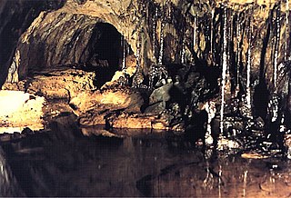
Sygun Copper Mine is a Victorian copper mine which closed in 1903 but was renovated and reopened by the Amies family as a tourist attraction in 1986, focusing on audio-visual tours of the underground workings. Sygun Copper Mine was once a main supplier of minerals in Wales. It is located about one mile (1.6 km) outside of the village of Beddgelert in the Snowdonia National Park in North Wales.

Mining in Wales provided a significant source of income to the economy of Wales throughout the nineteenth century and early to mid twentieth century. It was key to the Industrial Revolution in Wales, and to the whole of Great Britain.

Carl Schuchhardt was a German archaeologist and museum director. For many years, he was the director of the pre-historic department of the Ethnological Museum of Berlin. He was involved in numerous excavations, both in Europe and the Middle East, and contributed significantly to archaeological science. In his time, he was seen as Germany's most senior and accomplished prehistorian.

The Leadville mining district, located in the Colorado Mineral Belt, was the most productive silver-mining district in the state of Colorado and hosts one of the largest lead-zinc-silver deposits in the world. Oro City, an early Colorado gold placer mining town located about a mile east of Leadville in California Gulch, was the location to one of the richest placer gold strikes in Colorado, with estimated gold production of 120,000–150,000 ozt, worth $2.5 to $3 million at the then-price of $20.67 per troy ounce.
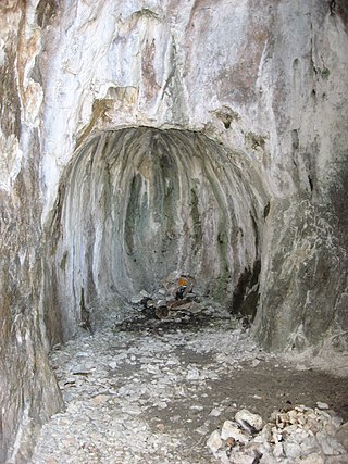
Fire-setting is a method of traditional mining used most commonly from prehistoric times up to the Middle Ages. Fires were set against a rock face to heat the stone, which was then doused with liquid, causing the stone to fracture by thermal shock. Rapid heating causes thermal shock by itself—without subsequent cooling—by producing different degrees of expansion in different parts of the rock. In practice, rapid cooling may or may not have been helpful to produce the desired effect. Some experiments have suggested that the water did not have a noticeable effect on the rock, but rather helped the miners' progress by quickly cooling down the area after the fire. This technique was best performed in opencast mines where the smoke and fumes could dissipate safely. The technique was very dangerous in underground workings without adequate ventilation. The method became largely redundant with the growth in use of explosives.

Mining in the Upper Harz region of central Germany was a major industry for several centuries, especially for the production of silver, lead, copper, and, latterly, zinc as well. Great wealth was accumulated from the mining of silver from the 16th to the 19th centuries, as well as from important technical inventions. The centre of the mining industry was the group of seven Upper Harz mining towns of Clausthal, Zellerfeld, Sankt Andreasberg, Wildemann, Grund, Lautenthal und Altenau.
The Schuyler Copper Mine is an abandoned, historic copper mine located in what is now North Arlington in Bergen County, New Jersey, United States. Operations began in 1715, making it the earliest copper mine in New Jersey and one of the oldest in the United States. In 1755, it was the site of the first use of a steam engine assembled in America. Later, starting in 1794, the first steam engine was manufactured in the United States near here. Shortly before and after, but not during, the American Revolutionary War, the mine was a major copper producer. Even though nothing remains of the mining operations above ground, the collapse of the underground shafts and tunnels caused damage as recently as 1989.
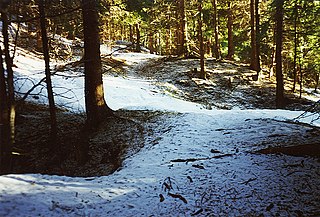
A Pinge or Binge ("binger") is the name given in German-speaking Europe to a wedge-, ditch- or funnel-shaped depression in the terrain caused by mining activity. This depression or sink-hole is frequently caused by the collapse of old underground mine workings that are close to the Earth's surface. Unlike natural landforms, a Pinge is a direct result of human activity. The term has no direct equivalent in English, but may be translated as "mining sink-hole", "mine slump" or, in some cases, as "glory hole".

The Alderley Edge Mines are located on the escarpment in Alderley Edge, Cheshire. Archaeological evidence indicates that copper mining took place here during Roman times and the Bronze Age, and written records show that mining continued here from the 1690s up to the 1920s. The site was the location of the Alderley Edge Landscape Project and the Pot Shaft Hoard.
The 3rd Canadian Tunnelling Company was one of the tunnelling companies of the Canadian Military Engineers during World War I. The tunnelling units were occupied in offensive and defensive mining involving the placing and maintaining of mines under enemy lines, as well as other underground work such as the construction of deep dugouts for troop accommodation, the digging of subways, saps, cable trenches and underground chambers for signals and medical services.
The Zeche Neuglück & Stettin in Witten-Muttental is a former mine, also known as the Zeche Stettin & Neuglück. It was created in the Stadtforst Mutteltal as a result of the Niemeyersche Karte, where there is now a fire station and is west of today's Berghauser Straße. The Stettin tunnel is now a component of the Bergbauwanderweg Muttental Muttental Mining trail.
Deep level underground is construction that is 20 m (66 ft) or more below ground and not using the cut-and-cover method, especially train stations, air raid shelters and bunkers, and some tunnels and mines. Cut-and-cover is a simple method of construction for shallow tunnels where a trench is excavated and roofed over with an overhead support structure that is strong enough to carry the load of what is to be built above the tunnel.
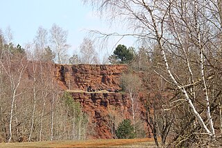
Mining in Luxembourg mostly refers to the extraction of iron ores, known as Minette. Iron-ore mining, both open-pit and underground, had significant economic and political importance in Luxembourg for an entire century, especially from the second half of the 19th century onwards. This was especially the case after modern technology made it possible to make use of the oolitic iron ores found in the region for iron and steel production. These iron ores were already known during Roman times, but the technological capabilities to exploit them did not yet exist.


