
The Halvergate Marshes are an area of grazing marsh in the east of the English county of Norfolk. They form part of the area of The Broads and lie between the River Bure and the River Yare, bordering Breydon Water on the east. The marshes cover an area of around 2,642 hectares An area of 1,432.7-hectare (3,540-acre) is a biological Site of Special Scientific Interest. Some areas are also in the Breydon Water Local Nature Reserve, the Broadland and Breydon Water Ramsar sites, The Broads Special Area of Conservation, and The Broads and Breydon Water Special Protection Areas.
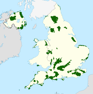
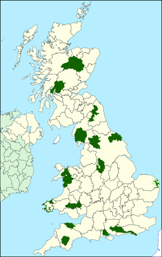
An Area of Outstanding Natural Beauty is one of 46 areas of countryside in England, Wales, or Northern Ireland that has been designated for conservation due to its significant landscape value. On 22 November 2023 the AONBs in England and Wales adopted a new name, National Landscapes, and are in the process of rebranding.

The South Downs are a range of chalk hills in the south-eastern coastal counties of England that extends for about 260 sq mi (670 km2) across the south-eastern coastal counties of England from the Itchen valley of Hampshire in the west to Beachy Head, in the Eastbourne Downland Estate, East Sussex, in the east. The Downs are bounded on the northern side by a steep escarpment, from whose crest there are extensive views northwards across the Weald. The South Downs National Park forms a much larger area than the chalk range of the South Downs, and includes large parts of the Weald.

CPRE, The Countryside Charity, formerly known by names such as the Council for the Preservation of Rural England and the Campaign to Protect Rural England, is a charity in England with over 40,000 members and supporters. Formed in 1926 by Patrick Abercrombie to limit urban sprawl and ribbon development, the CPRE claims to be one of the longest running environmental groups in the UK. CPRE campaigns for a "sustainable future" for the English countryside. They state it is "a vital but undervalued environmental, economic and social asset to the nation." They aim to "highlight threats and promote positive solutions." They campaign using their own research to lobby the public and all levels of government.
National parks of the United Kingdom are areas of relatively undeveloped and scenic landscape across the country. Despite their name, they are quite different from national parks in many other countries, which are usually owned and managed by governments as protected community resources, and which do not usually include permanent human communities. In the United Kingdom, an area designated as a national park may include substantial settlements and human land uses that are often integral parts of the landscape. Land within national parks remains largely in private ownership. These parks are therefore not "national parks" according to the internationally accepted standard of the IUCN but they are areas of outstanding landscape where planning controls are a little more restrictive than elsewhere.
The Countryside Stewardship Scheme was originally an agri-environment scheme run by the United Kingdom Government set up in 1991. In its original form it expired in 2014. It was relaunched for the Rural Development Programme England (RDPE) 2014-2020 with £3.1bn of government subsidy for agriculture and forestry, replacing the previous Environmental Stewardship scheme.
Environmental Stewardship is an agri-environment scheme run by the Department for Environment, Food and Rural Affairs in England which aims to secure widespread environmental benefits. It was formally launched on 18 March 2005, although the first agreements did not start until 1 August 2005.
England Rural Development Programme is the instrument by which the UK Department for Environment, Food and Rural Affairs (Defra) fulfills its rural development obligations in England, as set out by the European Union. It is derived primarily from Council Regulation European Union Regulation No. 1257/1999 and the related successive implementing Commission Regulations.

The North Wessex Downs National Landscape is located in the English counties of Berkshire, Hampshire, Oxfordshire and Wiltshire. The name North Wessex Downs is not a traditional one, the area covered being better known by various overlapping local names, including the Berkshire Downs, the North Hampshire Downs, the White Horse Hills, the Lambourn Downs, the Marlborough Downs, the Vale of Pewsey and Savernake Forest.
Natural England is a non-departmental public body in the United Kingdom sponsored by the Department for Environment, Food and Rural Affairs. It is responsible for ensuring that England's natural environment, including its land, flora and fauna, freshwater and marine environments, geology and soils, are protected and improved. It also has a responsibility to help people enjoy, understand and access the natural environment.

England comprises most of the central and southern two-thirds of the island of Great Britain, in addition to a number of small islands of which the largest is the Isle of Wight. England is bordered to the north by Scotland and to the west by Wales. It is closer to continental Europe than any other part of mainland Britain, divided from France only by a 33 km (21 mi) sea gap, the English Channel. The 50 km (31 mi) Channel Tunnel, near Folkestone, directly links England to mainland Europe. The English/French border is halfway along the tunnel.
An environmental management scheme is a mechanism by which landowners and other individuals and bodies responsible for land management can be incentivised to manage their environment.

The River Rye in the English county of North Yorkshire rises just south of the Cleveland Hills, east of Osmotherley, and flows through Hawnby, Rievaulx, Helmsley, Nunnington, West and East Ness, Butterwick, Brawby, and Ryton, before joining the River Derwent at 54°10′N00°44′W near Malton.

Hill farming or terrace farming is an extensive farming in upland areas, primarily rearing sheep, although historically cattle were often reared extensively in upland areas. Fell farming is the farming of fells, a fell being an area of uncultivated high ground used as common grazing. It is a term commonly used in Northern England, especially in the Lake District and the Pennine Dales. Elsewhere, the terms hill farming or pastoral farming are more commonly used.
The western Weald is an area of undulating countryside in Hampshire and West Sussex containing a mixture of woodland and heathland areas.
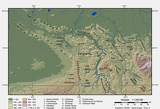
The Lippe Uplands is a range of hills in Ostwestfalen-Lippe within the administrative district of Detmold in the German state of North Rhine-Westphalia.
A National Character Area (NCA) is a natural subdivision of England based on a combination of landscape, biodiversity, geodiversity and economic activity. There are 159 National Character Areas and they follow natural, rather than administrative, boundaries. They are defined by Natural England, the UK government's advisors on the natural environment.

Catchment Sensitive Farming (CSF) is an English farm advice programme funded by the UK Government. It works with farmers, communities, and organisations across England to improve the quality of water, air, and sustainable water management. Since the programme’s creation it has reduced agricultural pollutant losses by 4–12% across target areas in England. CSF is led by Natural England in partnership with Department for Environment, Food and Rural Affairs and the Environment Agency.
The Clwydian Range and Dee Valley is a designated Area of Outstanding Natural Beauty (AONB) located in north-east Wales, covering the Clwydian Range, and the valley of the River Dee.