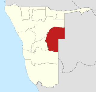
Omaheke is one of the fourteen regions of Namibia, the least populous region. Its capital is Gobabis. It lies in eastern Namibia on the border with Botswana and is the western extension of the Kalahari Desert. The self-governed villages of Otjinene, Leonardville and Witvlei are situated in the region. As of 2020, Omaheke had 48,594 registered voters.

Gobabis is a town in eastern Namibia. It is the regional capital of the Omaheke Region, and the district capital of the Gobabis electoral constituency. Gobabis is situated 200 km (120 mi) down the B6 motorway from Windhoek to Botswana. The town is 113 km (70 mi) from the Buitepos border post with Botswana, and serves as an important link to South Africa on the tarred Trans-Kalahari Highway. Gobabis is in the heart of the cattle farming area. In fact Gobabis is so proud of its cattle farming that a statue of a large Brahman bull with the inscription "Cattle Country" greets visitors to the town. Gobabis also has its own local airport.

The Popular Democratic Movement (PDM) is an amalgamation of political parties in Namibia, registered as one singular party for representation purposes. In coalition with the United Democratic Front, it formed the official opposition in Parliament until the parliamentary elections in 2009. The party currently holds 16 seats in the Namibian National Assembly and one seat in the Namibian National Council and is the official opposition. McHenry Venaani is president of the PDM.
Otjimbingwe is a settlement in the Erongo Region of central Namibia. Otjimbingwe has approximately 8,000 inhabitants and belongs to the Karibib electoral constituency.

Maharero kaTjamuaha was one of the most powerful paramount chiefs of the Herero people in South-West Africa, today's Namibia.
Munjuku Nguvauva II was a Namibian traditional paramount chief and leader of the Ovambanderu people, a subtribe of the Herero. Nguvauva was also deputy chief of Namibia's Traditional Leaders Council.

Heroes' Acre is an official war memorial of the Republic of Namibia. Built into the uninhabited hills 10 kilometres (6 mi) south of the city centre of Windhoek, Heroes' Acre opened on 26 August 2002. It was created to "foster a spirit of patriotism and nationalism, and to pass [this] to the future generations of Namibia".
Kahimemua Nguvauva was chief of the Ovambanderu, a Herero clan in Namibia.

Aminuis Constituency is an electoral constituency in the Omaheke Region of Namibia. It had 12,343 inhabitants in 2004 and 7,847 registered voters in 2020. The district capital is the settlement of Aminuis. The constituency forms part of the border between Namibia and Botswana.
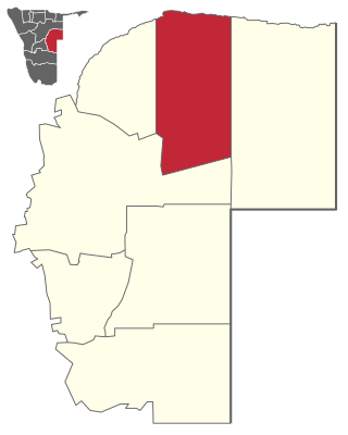
Epukiro Constituency is an electoral constituency in the Omaheke Region of Namibia. It had 6,101 inhabitants in 2004 and 4,646 registered voters in 2020. Its district capital is the settlement of Epukiro, it further contains the settlements of Otjinoko, Otjijarua, Omauezonjanda, and Otjimanangombe. The royal homestead of the Ovambanderu people is situated in this constituency in the settlement of Ezorongondo.

Leonardville is a village in eastern Namibia, situated on the Nossob River in the south-western corner of the Omaheke Region. It belongs to the Aminuis electoral constituency.

Franz Heinrich Kleinschmidt (1812–1864) was a German missionary and linguist who worked in southern Africa, now in the region of Namibia. He founded the missionary station and town of Rehoboth and together with Carl Hugo Hahn set up the first Rhenish mission station to the Herero people in Gross Barmen. Kleinschmidt is known for his scientific work on the Nama language.

Keharanjo II Xavier Komavau Nguvauva was the youngest Chief of the Ovambanderu, a Herero clan in Namibia. Keharanjo was born to the Ovambanderu family to the then Chief Munjuku Nguvauva II and his wife Aletta Karikondua Nguvauva. He was reported dead on the evening of Friday 8 April 2011 in the residential area of Khomasdal, Windhoek where he committed suicide using an electric wire.
The Red Nation is the main subtribe of the Nama people in Namibia and the oldest Nama group speaking Khoekhoegowab, the language often called Damara/Nama.
Ezorongondo is a settlement in the Epukiro Constituency in the Omaheke Region in Namibia. The village is the seat of the Ovambanderu royal house.
Nikanor Hoveka was chief of the Ovambanderu, a Herero clan in Namibia.

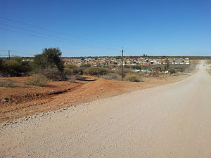
Aminuis is a cluster of small settlements in the remote eastern part of the Omaheke Region of Namibia, located about 500 km east of Windhoek. It is the district capital of the Aminuis electoral constituency.
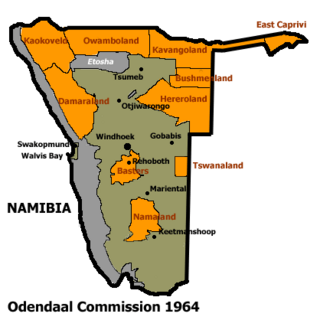
Constance Letang Kgosiemang was the paramount chief of the Tswana people in Namibia, a parliamentarian, and the leader of the Seoposengwe Party until its merger into the Democratic Turnhalle Alliance (DTA).
The Mbanderu are a population inhabiting eastern parts of Namibia and western parts of Botswana. They speak Otjiherero, a Bantu language.

Eiseb, also Eiseb Block, is a settlement in the Omaheke Region of Namibia. It is named after the Eiseb River, an ephemeral river (omuramba) in the Kalahari Desert. Eiseb is situated on the District road D1635 c. 350 kilometres (220 mi) northeast of Tallismanus and belongs to the Otjombinde electoral constituency.