Otjinene Constituency

Last updated
Otjinene Constituency
Constituency
Wahlkreis Otjinene in Omaheke.png
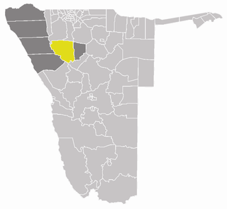
Otjinene Constituency (yellow) in the Omaheke Region (dark grey)
Coordinates: 21°13′28″S18°59′04″E / 21.224485°S 18.984444°E / -21.224485; 18.984444
CountryFlag of Namibia.svg  Namibia
Region Omaheke Region
Constituency Otjinene Constituency
Elevation
1,092 m (3,583 ft)
Population
 (2011) [1]
  Total7,400
  Density12,283/km2 (31,810/sq mi)
Time zone UTC+1 (South African Standard Time)
Area code(s) +66

Otjinene Constituency is an electoral constituency in the Omaheke Region of Namibia. It has 7,400 inhabitants [1] and its district capital is the village of Otjinene.

Constituencies of Namibia Wikimedia list article

Each of the 14 regions in Namibia is further subdivided into electoral constituencies. The size of the constituencies varies with the size and population of each region. There are currently 121 constituencies in Namibia. The most populous constituency is Walvis Bay Urban; the least populous is Walvis Bay Rural, both in the Erongo region.

Omaheke Region Region in Namibia

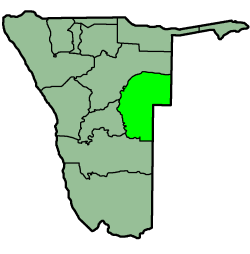
Omaheke is one of the fourteen regions of Namibia, its capital is Gobabis. It lies on the eastern border of Namibia and is the Western extension of the Kalahari desert. The name Omaheke is the Herero word for Sandveld.

Namibia republic in southern Africa

Namibia, officially the Republic of Namibia, is a country in southern Africa. Its western border is the Atlantic Ocean; it shares land borders with Zambia and Angola to the north, Botswana to the east and South Africa to the south and east. Although it does not border Zimbabwe, less than 200 metres of the Zambezi River separates the two countries. Namibia gained independence from South Africa on 21 March 1990, following the Namibian War of Independence. Its capital and largest city is Windhoek, and it is a member state of the United Nations (UN), the Southern African Development Community (SADC), the African Union (AU), and the Commonwealth of Nations.

Villages and settlements in Otjinene Constituency include: Otjiuaneho, Ehungiro, Okahungu, Goreses, Otjikova, Okorukurure, Otura, Ovijapa, Okomumbonde, Omungondo, Erindiroukambe, Okauua, Okonya, Okazapamba, Otjiuetjombungu, Okaoveni, Okatjana, Ozonduno, Epata, Erindiotjirarua, Okavangua, Ombujanjama, Otjipandjarua, Oukango, Otjimanahakane, Okate, Otjovengi, Otjipandjarua, Otjinoko, Okanokona, Ozondjou, Okarui, Ondiripumua, Otjikorondo, Orunarongue, Okawarongo, Okamuina, Ozongaru, Ozombeto, Ourundu, Ondorozu, Ovizuzu, Otjiteke.

Okazapamba Settlement in Omaheke Region, Namibia

Okazapamba is a settlement in the Otjinene Constituency in the Omaheke Region of eastern Namibia. It is mostly inhabited by Herero people and a minor group of the San people. The villagers' economic activities concentrate around cattle breeding, as "Herero people are a pastoral cattle breeding nation".

Politics

Otjinene is one of the few Namibian constituencies that are not dominated by the SWAPO Party. [2] The 2015 regional election was won by Erwin Katjizeu of the National Unity Democratic Organisation (NUDO) with 1,529 votes, followed by Nono Katjingisiua (SWAPO) with 965 votes. Albert Kandjii of the Democratic Turnhalle Alliance (DTA) finished third with 261 votes, followed by Issaskar Hiakaere of the South West Africa National Union (SWANU) with 78 votes. [3]

National Unity Democratic Organisation

The National Unity Democratic Organisation (NUDO) is a political party in Namibia. Esther Utjiua Muinjangue became the party’s first elected female president and the first elected female leader of a Namibian political party when she defeated the Okakarara constituency councillor, Vetaruhe Kandorozu, at the party’s third elective congress, which took place on 25-26 March 2019. At the elective congress, which was held in Windhoek, Peter Kazongominja was elected vice president and Joseph Kauandenge was elected secretary-general of the party. Muinjangue defeated the councillor by 240 to 227 votes. NUDO has been represented in the National Assembly of Namibia and in the National Council of Namibia since it split from the Democratic Turnhalle Alliance prior to the 2004 general and local elections.

Related Research Articles

Sibbinda Constituency constituency of Namibia

Sibbinda Constituency, also: Sibinda Constituency, is an electoral constituency in the Zambezi Region of Namibia. It is situated in the Caprivi Strip and is regularly affected by floods of the Zambezi River. The district capital is the village of Sibbinda. The constituency's population is 9,164.

Katima Mulilo Urban constituency of Namibia

Katima Mulilo Urban is a constituency in the Zambezi Region of Namibia, covering the capital city of the region, Katima Mulilo. As of 2004, the Constituency had 10,778 registered voters.

Katima Mulilo Rural constituency of Namibia

Katima Mulilo Rural is a constituency in the Zambezi Region of Namibia. Its population is 22,197. It comprises the area south of the city of Katima Mulilo, the regional capital.

Arandis Constituency constituency of Namibia

Arandis is a constituency in the Erongo Region of central-eastern Namibia. It had a population is 7,477 in 2004. It includes the towns of Arandis and Henties Bay. Asser Kuveri Kapere, Chairman of the National Council of Namibia beginning in December 2004, has represented the constituency from its establishment in 1992 until 2015.

Keetmanshoop Rural Electoral constituency of Namibia

Keetmanshoop Rural is an electoral constituency in the ǁKaras Region of Namibia. It contains the Krönlein suburb of Keetmanshoop and the villages of Koës and Aroab, the settlements of Seeheim and Klein Karas, as well as several farming communities in the area. The constituency office is situated in Aroab.

Katutura East constituency of Namibia

Katutura East is a constituency in the Khomas Region of Namibia. Its population is 17,737. It consists of the extensions 1, 6, and 19 of the suburb Katutura, a township within Windhoek that was founded by the then Apartheid government of Namibia for black people in the 1950s.

Khomasdal North is a constituency in Windhoek in the Khomas Region of Namibia. Its population is 26,621. The constituency consists of parts of the suburbs Khomasdal, Katutura, and Otjomuise.

Windhoek Rural constituency of Namibia

Windhoek Rural is a constituency in the Khomas Region of Namibia. Its district capital is the settlement of Groot Aub. As of 2010 its population was 20,212. This constituency contains all settlements in the Khomas Region that are outside the city of Windhoek, among them:

Kamanjab Constituency constituency in the Kunene Region of Namibia

Kamanjab is a constituency in the Kunene Region of Namibia. In 2004, the population was 6,012. The district capital is the settlement of Kamanjab.

Khorixas Constituency

Khorixas is a constituency in the Kunene Region of northwestern Namibia. Its population is 10,906, its district capital is the town of Khorixas. The name of this constituency comes from a derivation of the Khoekhoegowab word "Gorigas", which is a water bush that grows in the area. This area is famous for the Ugab Terraces, a stone monolith that can be seen from afar. There is also a petrified forest, and rock engravings in Twyfelfontein.

Rehoboth Urban West is an electoral constituency in the Hardap region of Namibia, comprising the suburbs of Rehoboth that are situated to the west of the national road B1. It has a population of 9201.

Rehoboth Urban East is an electoral constituency in the Hardap region of Namibia, comprising the suburbs of Rehoboth that are situated to the east of the national road B1. It has a population of 12,581.

Sesfontein Constituency

Sesfontein Constituency is an electoral constituency of Namibia. Located in Kunene Region, it has a population of 7,358. Its district capital is the settlement of Sesfontein. It is bordered by Khorixas Constituency to the south, Kamanjab Constituency to the east, Opuwo Rural to the north and Okahao Constituency in Omusati Region to the northeast.

Karibib Constituency constituency of Namibia

Karibib constituency is a constituency in the Erongo Region of Namibia. It had a population of 11,784 in 2004. The district capital is the town of Karibib.

Okakarara Constituency

Okakarara Constituency is an electoral constituency in the Otjozondjupa Region of Namibia. It has 21,336 inhabitants and consists of the town of Okakarara and the surrounding rural area.

Otjiwarongo Constituency

Otjiwarongo Constituency is an electoral constituency in the Otjozondjupa Region of Namibia. It has 22,614 inhabitants and consists of the town of Otjiwarongo and the surrounding rural area.

Tsumkwe Constituency

Tsumkwe Constituency is an electoral constituency in the Otjozondjupa Region of Namibia. It has 8,823 inhabitants and consists of the settlement of Tsumkwe and the surrounding rural area.

Otjinene Village in Omaheke Region, Namibia

Otjinene is a village in the Omaheke Region of Namibia. It is the district capital of Otjinene Constituency. Otjinene is connected via a 157 kilometres (98 mi) tarred road to the regional capital Gobabis, and via a 227 kilometres (141 mi) road to be tarred in 2017 to Grootfontein.

Opuwo Rural

Opuwo Rural is an electoral constituency in the Kunene Region of Namibia. It was created in August 2013, following a recommendation of the Fourth Delimitation Commission of Namibia, and in preparation of the 2014 general election. The administrative centre of Opuwo Rural is the settlement of Otuani.

References

  1. 1 2 "Table 2 Namibia 2011 Census Provisional Results: Population distribution by Sex and Area by Region/Constituency". Namibia 2011 - Population and Housing Census Preliminary Results. National Planning Commission. p. 44. Retrieved 22 July 2014.
  2. Menges, Werner (29 November 2015). "Mixed results for opposition in regional polls". The Namibian .
  3. "Regional Council Election Results 2015". Electoral Commission of Namibia. 3 December 2015. p. 16. Archived from the original on 8 December 2015.