The history of Namibia has passed through several distinct stages from being colonised in the late nineteenth century to Namibia's independence on 21 March 1990.
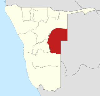
Omaheke is one of the fourteen regions of Namibia, its capital is Gobabis. It lies on the eastern border of Namibia and is the Western extension of the Kalahari desert. The name Omaheke is the Herero word for Sandveld.

The Herero and Nama genocide was the first genocide of the 20th century, waged by the German Empire against the Ovaherero, the Nama, and the San in German South West Africa. It occurred between 1904 and 1908.

Gobabis is a city in eastern Namibia. It is the regional capital of the Omaheke Region, and the district capital of the Gobabis electoral constituency. Gobabis is situated 200 km (120 mi) down the B6 motorway from Windhoek to Botswana. The town is 113 km (70 mi) from the Buitepos border post with Botswana, and serves as an important link to South Africa on the tarred Trans-Kalahari Highway. Gobabis is in the heart of the cattle farming area. In fact Gobabis is so proud of its cattle farming that a statue of a large Brahman bull with the inscription "Cattle Country" greets visitors to the town. Gobabis also has its own local Airport.

Omaruru is a city and constituency in the Erongo Region of Namibia. The town has 14,000 inhabitants and owns 352 square kilometres (136 sq mi) of land. The town is situated near Mount Erongo, on the usually dry Omaruru River. It is located on the main paved road from Swakopmund to Otjiwarongo. The name in the local Otjiherero language means 'bitter milk', as the cattle used to browse on a local bush that turned their milk bitter.

Samora Machel Constituency is a constituency in Windhoek in the Khomas Region of central Namibia. The constituency is located across four northern suburbs of Windhoek: Wanaheda, Greenwell Matongo, Goreangab, and part of Havana. It had a population of 50,110 in 2011, up from 29,382 in 2001.
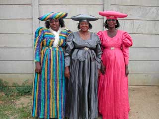
The Herero, also known as Ovaherero, are an ethnic group inhabiting parts of Southern Africa. The majority reside in Namibia, with the remainder found in Botswana and Angola. There were an estimated 250,000 Herero people in Namibia in 2013. They speak Otjiherero, a Bantu language.

Nama are an African ethnic group of South Africa, Namibia and Botswana. They traditionally speak the Nama language of the Khoe-Kwadi language family, although many Nama also speak Afrikaans. The Nama People are the largest group of the Khoikhoi people, most of whom have largely disappeared as a group, except for the Namas. Many of the Nama clans live in Central Namibia and the other smaller groups live in Namaqualand, which today straddles the Namibian border with South Africa.

Otjiwarongo is a city of 28,000 inhabitants in the Otjozondjupa Region of Namibia. It is the district capital of the Otjiwarongo electoral constituency and also the capital of Otjozondjupa.

Samuel Maharero was a Paramount Chief of the Herero people in German South West Africa during their revolts and in connection with the events surrounding the Herero genocide. Today he is considered a national hero in Namibia.

Namibian cuisine is the cuisine of Namibia. It is influenced by two primary cultural strands:

The Battle of Waterberg took place on August 11, 1904 at the Waterberg, German South West Africa, and was the decisive battle in the German campaign against the Herero.
Christian Afrikaner was the oldest son of Jonker Afrikaner and Beetje Boois. He became the fifth Captain of the mixed-race Orlam Afrikaners in South-West Africa, after the death of his father in 1861.

Swartbooisdrift is a small settlement in Kunene Region in the north of Namibia. It is situated on the banks of the Kunene River, directly at the Angolan border on the minor road D3700 and falls within the Epupa electoral constituency. Swartbooisdrift is populated by 150 - 300 semi-nomadic people of Himba and Herero descent, depending on the season.
Seeis is a small settlement in the Khomas Region of central Namibia. It is situated on the B6 national road 11 km (6.8 mi) east of Hosea Kutako International Airport on the turnoff of the dirt road D1458. The Seeis Rivier, an ephemeral river, cuts the settlement. Seeis is a railway stop on the Windhoek - Gobabis railway line.

Otjinene is a village in the Omaheke Region of Namibia. It is the district capital of Otjinene Constituency. Otjinene is connected via a 157 kilometres (98 mi) tarred road to the regional capital Gobabis, and via a 227 kilometres (141 mi) road which was tarred in 2017 from Otjinene to Grootfontein.
The Cimba[tʃimba], also spelled Tjimba, are a remote, Herero-speaking hunter-gatherer people of the Kaokoveld desert in northwest Namibia and southwest Angola, in the mountain ranges bordering the Kunene River. They continue to use stone tools, and use Adenium boehmianum to poison their arrows.

Epukiro is a cluster of small settlements in the remote eastern part of the Omaheke Region of Namibia, situated about 120 kilometres (75 mi) northeast of the regional capital Gobabis. The centre of the populated area is the Catholic mission station. Epukiro had about 3,200 inhabitants in 1997, predominantly ethnic Tswana.

Aminuis is a cluster of small settlements in the remote eastern part of the Omaheke Region of Namibia, located about 500 km east of Windhoek. It is the district capital of the Aminuis electoral constituency.
The Mbanderu (Ovambanderu) are a population inhabiting eastern parts of Namibia and western parts of Botswana. They speak Herero (Otjiherero), a Bantu language.
