
Kottayam is one of 14 districts in the Indian state of Kerala. Kottayam district comprises six municipal towns: Kottayam, Changanassery, Pala, Erattupetta, Ettumanoor, and Vaikom. It is the only district in Kerala that does not border either the Arabian Sea or another Indian state.

Pathanamthitta District, is one of the 14 districts in the Indian state of Kerala. The district headquarters is in the town of Pathanamthitta. There are four municipalities in Pathanamthitta: Adoor, Pandalam, Pathanamthitta and Thiruvalla.

Wayanad is a district in the north-east of the Indian state of Kerala, with administrative headquarters at the municipality of Kalpetta. It is the only plateau in Kerala. The Wayanad Plateau forms a continuation of the Mysore Plateau, the southern portion of the Deccan Plateau. It is set high in the Western Ghats with altitudes ranging from 700 to 2,100 meters. Vellari Mala, a 2,240 m (7,349 ft) high peak situated on the trijunction of Wayanad, Malappuram, and Kozhikode districts, is the highest point in Wayanad district. The district was formed on 1 November 1980 as the 12th district in Kerala, by carving out areas from Kozhikode and Kannur districts. An area of 885.92 km2 in the district is forested. Wayanad has three municipal towns—Kalpetta, Mananthavady and Sulthan Bathery. There are many indigenous tribes in this area. The Kabini River, a tributary of the Kaveri River, originates at Wayanad. Wayanad district, along with the Chaliyar valley in the neighbouring Nilambur in Malappuram district, is known for natural gold fields, which are also seen in other parts of the Nilgiri Biosphere Reserve. The Chaliyar river, which is the fourth longest river of Kerala, originates on the Wayanad plateau. The historically important Edakkal Caves are located in Wayanad district.
Mundakayam, is a town in Kanjirappally Taluk in the Kottayam District of Kerala. It is the doorway to the high ranges of southern Kerala, and is at the border of Kottayam and Idukki districts. The next nearest town, Kanjirappally, is 14 km (8.7 mi) & Erumely is 12 km from Mundakayam. Mundakayam has rubber plantations, and greenery. The Manimala River runs through Mundakayam. It is located 48 km east of the district headquarters at Kottayam and 148 km from the state capital, Thiruvananthapuram. The name Mundakayam is said to be derived from the Mundi cranes that used to be seen along the Manimala River banks.

Gudalur is a municipality and taluk in Nilgiris district in the Indian state of Tamil Nadu.
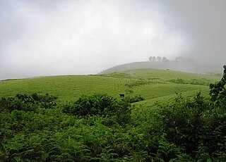
Vagamon is an Indian hill station and a revenue village located in Peerumedu Taluk of Idukki district, and also Meenachil taluk and Kanjirappally taluk of Kottayam district in the state of Kerala, India. Located in the Western Ghats 25 kilometres (16 mi) east of Erattupetta on the border of Kottayam-Idukki districts, Vagamon is famous for its natural beauty. The Vagamon glass bridge is the longest cantilever glass bridge in India.
Nelliyalam is a panchayat town in The Nilgiris district in the Indian state of Tamil Nadu. As of 2011, the town had a population of 44,590.
O' Valley or Ouchterlony Valley is a Town Panchayat in the Gudalur Taluk of The Nilgiris district in the Indian state of Tamil Nadu. The name is a contraction of an older name after a James Ouchterlony, who established coffee plantations in the area. This panchayat area is located between Mudumalai National Park and New Amarambalam Reserved Forest and has several valleys, streams and water falls.

Peermade, also spelt Peerumedu is a village, Grama Panchayat and hill station in the state of Kerala, in southwestern India. It lies 915 metres (3,002 ft) above sea level in the Western Ghats (Sahyadri) about 85 kilometres (53 mi) east of Kottayam on the way to Thekkady through the nearby city of Kanjirappally.

Wandoor is a town in Nilambur Taluk, Malappuram District, Kerala, India. It is located on the southeast of Chaliyar River, about 24 kilometres northeast of the district seat Malappuram, and 8 km south of the taluk seat Nilambur. In the year 2011, the town has a population of 50,973.
Chengalam is a village situated in the east of Kottayam District in India.

Erumely, also spelt Erumeli, is a town and panchayat located in the south-eastern part of Kottayam district in Kerala state, India. Erumely is situated 49 km (30 mi) east of Kottayam town and 133 km (83 mi) north of capital city Thiruvananthapuram. The village is on the Manimala River.

Cheruvally is a Village in Chirakkadavu panchayat of Kottayam district in Kerala. It is in Kanjirappally taluk, Kottayam district. There is a Bhadrakali temple viz., Cheruvally Devi Temple in Cheruvally.

Thevalakkara is a village in the Karunagappally Taluk, Kollam District of the state of Kerala, India. It is located near the coast of the Indian Ocean, about 13 kilometres north of the district capital Kollam, and 7 kilometres southeast of the subdistrict capital Karunagappally. It contains a Devi temple along with a church and a mosque. The kadappa at Thevalakara is where ship masts (kadappa) were made for centuries. In 2011, it has a total population of 42,977.
Edakkunnam is a village in Kanjirappally Taluk of Kottayam district in the state of Kerala, India. The nearest town is Kanjirappally.
Chinchali is a village in Raybag Taluk, Belagavi District, Karnataka, India. It is located near the state boundary with Maharashtra, approximately 84 kilometres north of the district seat Belgaum, and 10 kilometres northeast of the taluk seat Raibag. In the year 2011, the village has a population of 18,986.
Gudalur taluk is a taluk of Nilgiris district of the Indian state of Tamil Nadu. The headquarters of the taluk is the town of Gudalur.
Pandalur taluk is a taluk of Nilgiris district of the Indian state of Tamil Nadu. The headquarters of the taluk is the town of Pandalur.

Kuruva is a village in Perinthalmanna Taluk, Malappuram District, Kerala, India. It is located along the National Highway 966, about 6 kilometres southeast of the district seat Malappuram, and 13 kilometres northwest of the taluk seat Perinthalmanna. As of the 2011 India Census, the population was 38,153.
Sabarimala Railway is a proposed 111-kilometre (69 mi)-long railway line in Kerala, India, that will run from Angamaly to Erumeli. It was sanctioned in 1998 by Indian Railways. The line's name comes from the fact that it will provide a railway facility to pilgrims visiting the Sabarimala Temple.

