
Liechtenstein, officially the Principality of Liechtenstein, is a doubly landlocked German-speaking microstate located in the Alps between Austria and Switzerland. It is the sixth smallest nation worldwide. Liechtenstein is a semi-constitutional monarchy headed by the prince of Liechtenstein.

Political identity came to the territory now occupied by the Principality of Liechtenstein in 814, with the formation of the subcountry of Lower Rhætia. Liechtenstein's borders have remained unchanged since 1434, when the Rhine established the border between the Holy Roman Empire and the Swiss cantons.

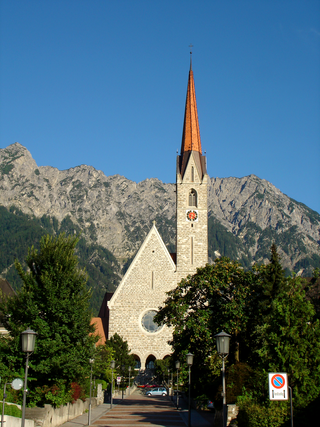
Vaduz is the capital of Liechtenstein and also the seat of the national parliament. The city, which is located along the Rhine River, has 5,696 residents. The most prominent landmark of Vaduz is Vaduz Castle, perched atop a steep hill overlooking the city. It is home to the reigning prince of Liechtenstein and the Liechtenstein princely family. The city's distinctive architecture is also displayed in landmarks such as the Cathedral of St. Florin, Government House, City Hall, the National Art Gallery, as well as the National Museum. Although Vaduz is the best-known town in the principality internationally, it is not the largest; neighbouring Schaan has a larger population.

The Rätikon is a mountain range of the Central Eastern Alps, located at the border between Vorarlberg, Liechtenstein and Graubünden. It is the geological border between the Eastern and Western Alps and stretches from the Montafon as far as the Rhine. In the south, the Prättigau is its limit, and in the north, it is the Walgau. In the east, it borders the Silvretta groups. The Rätikon mountain range derives its name from Raetia, a province of the Roman Empire, named after the Rhaetian people.

Schellenberg is a municipality in the lowland area of Liechtenstein, on the banks of the Rhine. As of 2019, it has a population of 1,107 and covers an area of 3.5 km2 (1.4 sq mi)
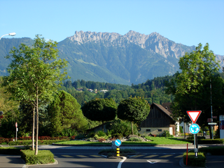
Schaan is the largest municipality of Liechtenstein by population. It is located to the north of Vaduz, the capital, in the central part of the country. As of 2019 it has a population of 6,039, making it the most populous administrative district in Liechtenstein. Representing an important traffic hub and industrial location of the country, Schaan covers an area of 26.8 km2 (10.3 sq mi), including mountains and forest. It is a municipality within the electoral district of Oberland in the Principality of Liechtenstein. Schaan contains four enclaves: Brunnenegg, Gritsch, Guschg, and Plankner Neugrütt.

Feldkirch is a town in the western Austrian state of Vorarlberg, bordering on Switzerland and Liechtenstein. It is the administrative centre of the Feldkirch district. After Dornbirn, it is the second most populous town in Vorarlberg. The westernmost point in Austria lies in Feldkirch on the river Rhine, at the tripoint between Austria, Switzerland, and Liechtenstein.

Planken is a municipality in Oberland, Liechtenstein. It has four exclaves, two enclaves and a population of 473. Thus by population it is the smallest municipality of Liechtenstein.
Ruggell is a municipality of Liechtenstein. It is the northernmost and lowest elevated municipality. As of 2019, it has a population of 2,322.

Gamprin is a municipality of Liechtenstein, on the Rhine on the border with the municipality of Sennwald, in Switzerland. It had 1,690 inhabitants in 2019. The municipality contains the village of Bendern and scattered hamlets and the Liechtenstein Institute and LGT Group.

Bendern is a village of Liechtenstein, together with the town of Gamprin it forms in the municipality of Gamprin. It is the third smallest in the country, with an area of 6.19 km2 and a total population of 1664 people. The village itself had about 470 residents.
The following outline is provided as an overview of and topical guide to Liechtenstein:

Obere Burg, also known colloquially as Burg Neu-Schellenberg, is a castle ruin located in the municipality of Schellenberg, Liechtenstein. It lies at the western edge of Hinterschloss, one of the burroughs in the village of Neu-Schellenberg. It is freely open to tourists. Due to its close proximity to Hinterschloss, it is probably the most easily accessible of all Liechtenstein castles. Obere Burg is one of the five existing castles in Liechtenstein and one of the three ruined ones in the country.

Alfons Goop was a Liechtensteiner politician during World War II. He was the leader of the German National Movement in Liechtenstein, a Nazi Party that aimed to unify with Nazi Germany.

Germany–Liechtenstein relations are the diplomatic relations between Germany and Liechtenstein. Both states are members of the Organization for Security and Cooperation in Europe (OSCE), the Council of Europe and the European Economic Area.

Georg Malin is a Liechtensteiner artist, sculptor, historian and politician. Between 1974 and 1978, Malin served as member of the governing council in the Liechtenstein government, for the Progressive Citizens Party (FBP). He previously served as a member of the Landtag of Liechtenstein from 1966 to 1974, where he was also a member on the parliamentary delegation to the European Council.
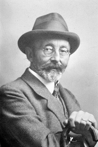
Josef Peer was an Austrian lawyer and politician who served as the Governor of Liechtenstein from 1920 to 1921.
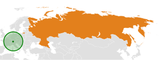
Foreign relations between Russia and it's predecessors with Liechtenstein date back to the Napoleonic wars. Both countries established diplomatic relations on 30 January 1994. Since then, relations between the two countries have been distant, with Liechtenstein condemning the Russian invasion of Ukraine.
The 1939 Liechtenstein putsch, also known as the Annexation putsch was an unsuccessful coup d'état by the German National Movement in Liechtenstein designed to provoke Liechtenstein's annexation into Nazi Germany.
