Espoonlahti

Last updated
Espoonlahti
Esboviken
Espoo districts Espoonlahti.png
Location of Espoonlahti within Espoo shown in green, Kanta-Espoonlahti in red.
Coordinates: 60°9′00″N24°39′30″E / 60.15000°N 24.65833°E / 60.15000; 24.65833
Country Finland
Municipality Espoo
Region Uusimaa
Sub-region Greater Helsinki
Main DistrictSuur-Espoonlahti
Inner District(s)Espoonlahden keskus, Kivenlahti, Laurinlahti, Soukka
Population
 (2013/14)
  Total52,465 [1]
Languages
  Finnish83.0 %
  Swedish9.5 %
  Other7.4 %
Jobs2,821

Espoonlahti (Finnish) or Esboviken (Swedish) (literally The Bay of Espoo or Espoo Bay) is one of the five major urban areas of Espoo, a city in Finland. [2] It lies along the south-western coast of Espoo, bounded to the west by the bay of the same name, to the south by the shores of the Gulf of Finland, to the west by the Finnoo (Finnå) valley, to the east of the municipal border of Kirkkonummi, and to the north by the forests of Espoo central forest area. [3] This total area of about 4,800 hectares is further divided into areas called Soukka, Suvisaaristo, Kaitaa, Nöykkiö, Latokaski and Saunalahti, with one greater center called Espoonlahden keskus ( Espoonlahti center). Areas known as Laurinlahti, Ylä-Kivenlahti, Ala-Kivenlahti and Iivisniemi are also part of the Espoonlahti district. Yet another name pertinent to this area is Kanta-Espoonlahti (Espoonlahti Proper), which includes Espoonlahden keskus, Soukanmäki (Soukka Hill), Kivenlahti, Laurinlahti and Soukanniemi (Soukka Peninsula). [4]

Contents

History

An aerial view of Espoonlahti with Kivenlahti in the foreground, 2003. Kivenlahti ilmasta.jpg
An aerial view of Espoonlahti with Kivenlahti in the foreground, 2003.

Areas along the Bay of Espoonlahti as well as the shores and islands of the Gulf of Finland belong to the oldest inhabited parts of Espoo with traces of human presence reaching to the Bronze Age. [5] [6] Certain pollens in sediment samples from Lake Hannusjärvi indicate permanent inhabitation and agriculture in and around the Bay of Finnoonlahti area about year 1000. [7] The oldest villages in Espoonlahti are those of Soukka and Kivenlahti. They were important enough to be marked by their Swedish names Sökö and Stensvik on maps as early as in 1540. [8] Espoonlahti Bay provided an important route for the Hanse trade ships and for those of the farmer salesmen from Espoo inland villages. [9] Like all Espoo this area was still a typical rural area in the 1860s - only seldom disturbed by any industrial activity. [10] The vast majority of changes that lead to modern Espoonlahti started with a great influx of new inhabitants after World War II. [11] Things started to move rapidly after the Soviet Union returned the neighbouring Porkkala in 1956. [9] [10] The 1960s saw joined regional planning efforts between architects and housing companies who aimed to plan and build entire housing areas at one go. [11] Those for the Soukka - Kivenlahti area were drawn by Alvar Aalto in 1964, [12] while plans made for Laurinlahti by Espoo planners were successfully opposed by local residents assisted by the brothers Suomalainen. [10] The most northerly point of Espoonlahti on the Bay of Espoonlahti is Saunalahti (Bastvik), whose urbanisation started in 2001 with asphatisation old roads and was followed in 2002 by intensive construction work of mainly residential buildings. [13]

Modern times

Espoonlahti in 2022. Espoonlahden keskus 080722.jpg
Espoonlahti in 2022.

With more than 52 000 inhabitants Espoonlahti is today the second largest of Espoo urban centers. [14] It is a markedly residential area that in 2004 was able to employ 39% of its inhabitants. [15] Espoonlahti center is characterized by a tree lined shopping street Espoonlahdenkatu, where most of the services are found. Among them is the shopping center Lippulaiva built in 1994, the market place, several banks and some small restaurants. The swimming hall, health center and Espoonlahti Church are all found close by. [16] As Espoonlahden keskus is one of the stations of the western branch of the Helsinki metropolitan area underground (Länsimetro), [17] further urban development is ongoing there. It includes several residential buildings, facilities for cultural services and an addition to Lippulaiva, which lies in the vicinity of the underground station, [18] opened in 2022. There are five stations in the greater Espoonlahti area: Finnoo, Kaitaa, Soukka, Espoonlahti and Kivenlahti.

See also

Related Research Articles

<span class="mw-page-title-main">Espoo</span> Second-most populous city in Finland

Espoo is a city in Finland, located to the west of the capital, Helsinki, in southern Uusimaa. The population of Espoo is approximately 314,000. It is the 2nd most populous city in Finland. Espoo is part of the Helsinki Metropolitan Area, which has approximately 1.58 million inhabitants.

<span class="mw-page-title-main">Otaniemi</span> District in Espoo, Finland

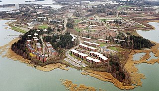
Otaniemi (Finnish), or Otnäs (Swedish), is a district of Espoo, Finland. It is located near the border of Helsinki, the capital of Finland.

<span class="mw-page-title-main">Helsinki University of Technology</span> Former technical university in Finland

Helsinki University of Technology was a technical university in Finland. It was located in Otaniemi, Espoo in the metropolitan area of Greater Helsinki. The university was founded in 1849 by Grand Duke of Finland, Emperor Nicholas I and received university status in 1908. It moved from Helsinki to Otaniemi campus area in 1966. The merger of HUT with two other schools created the Aalto University in 2010, and HUT briefly held the name Aalto University School of Science and Technology before being split into four schools in 2011.

<span class="mw-page-title-main">Helsinki Metro</span> Greater Helsinki, Finland rapid transit system

The Helsinki Metro is a rapid transit system serving Greater Helsinki, Finland. It is the world's northernmost metro system. It was opened to the general public on 2 August 1982 after 27 years of planning. It is operated by Helsinki City Transport and Metropolitan Area Transport Ltd for Helsinki Regional Transport Authority and carries 92.6 million passengers per year.

<span class="mw-page-title-main">Länsimetro</span> Extension of the Helsinki Metro in Espoo, Finland

Länsimetro is an extension to the Helsinki Metro system in Finland, which opened on 18 November 2017. Länsimetro extends the system's two lines, M1 and M2, from Central Helsinki to the neighbouring city of Espoo. The new stretch continues the lines from the existing Ruoholahti station via the island of Lauttasaari, the Aalto University Otaniemi campus and Tapiola, the terminus of line M2. Line M1 continues further west to Matinkylä. Unlike previous extensions to the Helsinki Metro system, Länsimetro runs entirely underground. The second phase opened on 3 December 2022 and continues the line further west to Kivenlahti, near the municipal border of Kirkkonummi.

<span class="mw-page-title-main">Espoon keskus</span> District of Espoo in Finland

Espoon keskus is the central district of Espoo, the second biggest city of Finland and the administrative centre with the city hall of Espoo. The areas of Kiltakallio, Kirkkojärvi, Saarniraivio, Suna, Suvela and Tuomarila belong to Espoon keskus. To the east, Espoon keskus borders the city of Kauniainen, an enclave within the city of Espoo.

<span class="mw-page-title-main">Haukilahti</span> District of Espoo in Finland

Haukilahti is a neighbourhood in Espoo, Finland. It is located on the seashore of the Gulf of Finland in the southern part of the city.

<span class="mw-page-title-main">Länsiväylä</span> Motorway in Uusimaa, Finland

Länsiväylä is a motorway in the Greater Helsinki area of Finland, mainly at the Helsinki conurbation. It is part of the Finnish national road 51. The road begins in Ruoholahti in western Helsinki and continues west through the island of Lauttasaari and then across the city border to Espoo. The Länsiväylä road continues all the way throughout the southern part of Espoo. It continues as a motorway until finally crossing the border west to Kirkkonummi.

This is an alphabetical list of the fifty districts of Espoo. Swedish names are given in parentheses.

<span class="mw-page-title-main">Niittykumpu</span> District of Espoo in Finland

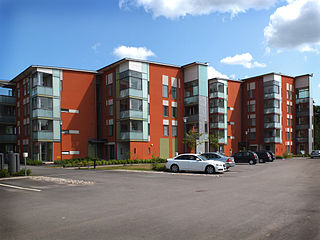
Niittykumpu (Finnish) or Ängskulla (Swedish) is a district of Espoo, a city in Finland. The districts belongs to the major district of Suur-Tapiola. The district, partly located on the eastern lands of the former Gräsa manor, started developing along with the rest of southern Espoo in the 1930s when the street Jorvaksentie was completed. The first significant construction phase of Niittykumpu happened during the 1960s and 1970s, when a large number of terraced houses were built in the area because of rapid growth of the city of Espoo. Construction slowed down during the early 1990s depression in Finland. Construction picked up pace again in the 2000s and increased even further during the construction of the Länsimetro transport line.

<span class="mw-page-title-main">Laajalahti</span> District of Espoo in Finland

Laajalahti is a district of Espoo, a city in Finland. It belongs to the area of Suur-Tapiola together with Westend, Tapiola, Pohjois-Tapiola, Otaniemi, Niittykumpu, Mankkaa, and Haukilahti. It gets its name from the bay on which it is located. Laajalahti belongs to three sectors; Laajaranta, Lupauksenvuori, and Ruukinranta.

<span class="mw-page-title-main">Aalto University</span> Public university in Espoo, Finland

Aalto University is a public research university located in Espoo, Finland. It was established in 2010 as a merger of three major Finnish universities: the Helsinki University of Technology, the Helsinki School of Economics and the University of Art and Design Helsinki. The close collaboration between the scientific, business and arts communities is intended to foster multi-disciplinary education and research.

<span class="mw-page-title-main">Rantaraitti</span> Hiking route along the coast of Espoo, Finland

The rantaraitti (Finnish) or strandpromenaden (Swedish) is an urban hiking and cycling route along the coastline of Espoo, Finland, bordering the Gulf of Finland. The approximate total length of the route is 27 km.

<span class="mw-page-title-main">Saunalahti, Espoo</span> District of Espoo in Finland

Saunalahti (Finnish) or Bastvik (Swedish) is one of the newest apartment building districts in Espoo, Finland, located by the Kummelivuori hill between Kivenlahti and Kurttila, west of the Kauklahdenväylä road, on the coast of the Espoonlahti bay. The bay at Saunalahti is named Bastvikfjärden. The area also contains original detached house residence from old Saunalahti and agriculture. Saunalahti is separated from Kivenlahti by the Länsiväylä highway, continuing to Kirkkonummi as Jorvaksentie.

<span class="mw-page-title-main">Tuomo Suomalainen</span> Finnish architect

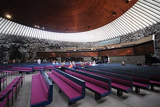
Tuomo Oskari Suomalainen was a Finnish architect. He worked very closely with his brother Timo Suomalainen who also was an architect. Most of the works they designed jointly.

<span class="mw-page-title-main">Espoonlahti Church</span>

Espoonlahti Church is a Lutheran church situated in Espoonlahti, Espoo, Finland. It was designed by architects Timo and Tuomo Suomalainen, architects of the Rock Church, who were also members of the Espoonlahti congregation. The groundstone for the church was set in August 1979 and the building was completed in 1980. The organs were built and assembled in 1983. As the number of members in the congregation grew rapidly, additional rooms were soon needed. This new phase of building was completed in 1987, also by the architects Suomalainen.

Villa Tammekann is a residential building located in Tartu, Estonia, notable for being one of few private residences designed by the Finnish architect Alvar Aalto, his first design to be realised outside Finland, and the only one located in Estonia or anywhere in the Baltic states.

Finnoo is a neighbourhood in the districts of Kaitaa and Nöykkiö in Espoo, Finland, along the Länsiväylä highway.

<span class="mw-page-title-main">Suurpelto</span> Area of Espoo, Finland

Suurpelto is an area under construction in Espoo, Finland, between the districts of Henttaa, Mankkaa and Olari.

References

Notes

  1. "Espoo census 2013/2014". Archived from the original on 2014-10-23. Retrieved 2015-08-31.
  2. Districts on Espoo official web site
  3. Map showing Espoonlahti borders
  4. "Espoonlahden alueellinen esteettömyyskartoitus". Espoo, Tekninen keskus. December 2009. Retrieved 5 September 2015.Page 5.(in Finnish)
  5. Pekkanen&Heininen 2013, pages 10-11.
  6. Espoonlahden ae 2009, page 48.
  7. Kylä, page 75.
  8. Pekkanen&Heininen 2013, page 12.
  9. 1 2 "Espoon kotikaupunkipolut" (PDF). 30 September 2014.
  10. 1 2 3 Saloranta, Pauli (30 September 2014). "Espoon kotikaupunkipolut - Espoonlahti" (PDF). Espoo.fi. Espoo. Retrieved 6 September 2015.
  11. 1 2 Lahti 1975, page 329.
  12. "YLE Teema | Sininen laulu | Taiteilijat | Arkkitehtuuri ja taideteollisuus | Aalto Alvar ja Aino". yle.fi. Retrieved 2015-09-07.
  13. "Urban measurement sites". Water.tkk.fi. TKK, Water Resources Engineering. 17 November 2003. Archived from the original on 5 March 2016. Retrieved 7 September 2015.
  14. "Vuodenvaihteen väestö". Espoo.fi (in Finnish). Espoo. 11 April 2014. Archived from the original on 23 October 2014. Retrieved 5 September 2015.Espoonlahti census turn of the year 2013/2014.
  15. Espoonlahden ae 2009, page 21.
  16. Espoonlahden ae 2009, pages 19-21.
  17. "Espoonlahti underground station on the Länsimetro project site". Archived from the original on 2016-05-21. Retrieved 2015-09-08.
  18. Kaavoituskatsaus 2015 (in Finnish). Espoo. 2015. pp. 42–44. Archived from the original on 4 March 2016. Retrieved 5 September 2015.A look into town planning 2015.