
Helsinki is the capital, primate, and most populous city of Finland. Located on the shore of the Gulf of Finland, it is the seat of the region of Uusimaa in southern Finland and has a population of 665,558. The city's urban area has a population of 1,268,296, making it by far the most populous urban area in Finland as well as the country's most important center for politics, education, finance, culture, and research. Helsinki is located 80 kilometres (50 mi) north of Tallinn, Estonia, 400 km (250 mi) east of Stockholm, Sweden, and 300 km (190 mi) west of Saint Petersburg, Russia. It has close historical ties with these three cities.

Vantaa is a city and municipality in Finland. It is part of the inner core of the Finnish Capital Region along with Helsinki, Espoo, and Kauniainen. With a population of 243,496, Vantaa is the fourth most populated city in Finland after Helsinki, Espoo and Tampere. Its administrative center is the Tikkurila district. Vantaa is bordered by Helsinki, the Finnish capital, to the south; Espoo to the southwest; Nurmijärvi to the northwest; Kerava and Tuusula to the north; and Sipoo to the east. The city encompasses 240.35 square kilometres (92.80 sq mi), of which 1.97 km2 (0.76 sq mi) is water.

Espoo is a city and municipality in the region of Uusimaa in the Republic of Finland. It is located on the northern shore of the Gulf of Finland, bordering the cities of Helsinki, Vantaa, Kirkkonummi, Vihti and Nurmijärvi while surrounding the enclaved town of Kauniainen. The city covers 528.03 square kilometres (203.9 sq mi) with a population of about 300,000 residents in 2022, making it the 2nd-most populous city in Finland. Espoo forms a major part of a substantially larger metropolitan area known as Greater Helsinki, home to over 1.5 million people in 2020.

Kauniainen is a small town and a municipality of 10,248 inhabitants in the Helsinki Metropolitan Area, Finland. It is surrounded and enclaved by the City of Espoo, in the Capital Region of Greater Helsinki. Kauniainen was founded by a corporation in 1906, AB Grankulla, that parcelled land and created a suburb for villas; Kauniainen received the status of a market town in 1920, the Finnish name in 1949 and the title of kaupunki in 1972.
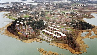
Otaniemi (Finnish), or Otnäs (Swedish), is a district of Espoo, Finland. It is located near the border of Helsinki, the capital of Finland.

Matinkylä is one of the major districts of Espoo, a city on the southern coast of Finland. Matinkylä sits between the Länsiväylä highway and the coast of the Gulf of Finland, between the areas of Haukilahti and Iivisniemi.

Vuosaari is a neighbourhood in the City of Helsinki, Finland. It is located by the sea in East Helsinki and with its area of 15.38 km2 (5.94 sq mi) is geographically the largest district in the city. It also has two Helsinki Metro stations, Rastila and Vuosaari

Katajanokka is a neighbourhood of Helsinki, Finland, with around 4000 inhabitants in 2005. The district is located adjacent to the immediate downtown area, though in the first major town plan for Helsinki from the mid-18th century, the area fell outside the fortifications planned to encircle the city.

Lauttasaari is an island in Helsinki, Finland, about 3 kilometres (1.9 mi) west of the city centre. Together with some surrounding unpopulated small islands, Lauttasaari is also a district of Helsinki. With 23,226 residents as of 2017, the island is Finland's second largest by population, after Fasta Åland. Its land area is 3.85 km2.

Länsimetro is an extension to the Helsinki Metro system in Finland. The grand opening for the long-awaited extension was held on 18 November 2017. Länsimetro extends the system's two lines, M1 and M2, from Central Helsinki to the neighbouring city of Espoo. The new stretch continues the lines from the existing Ruoholahti station via the island of Lauttasaari, the Aalto University Otaniemi campus and Tapiola, the terminus of line M2. Line M1 continues further west to Matinkylä. Unlike previous extensions to the Helsinki Metro system, Länsimetro runs entirely underground. The second phase opened on December 3, 2022 and continue the line further west to Kivenlahti, which is located near the municipal border of Kirkkonummi.

Espoon keskus is the central district of Espoo, the second biggest city of Finland and the administrative centre with the city hall of Espoo. The areas of Kiltakallio, Kirkkojärvi, Saarniraivio, Suna, Suvela and Tuomarila belong to Espoon keskus. To the east, Espoon keskus borders the city of Kauniainen, an enclave within the city of Espoo.

Haukilahti is a neighbourhood in Espoo, Finland. It is located on the seashore of the Gulf of Finland in the southern part of the city.

Länsiväylä is a motorway in the Greater Helsinki area of Finland, mainly at the Helsinki conurbation. It is part of the Finnish national road 51. The road begins in Ruoholahti in western Helsinki and continues west through the island of Lauttasaari and then across the city border to Espoo. The Länsiväylä road continues all the way throughout the southern part of Espoo. It continues as a motorway until finally crossing the border west to Kirkkonummi.
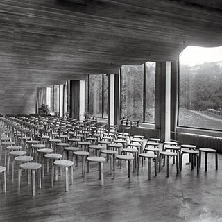
The architecture of Finland has a history spanning over 800 years, and while up until the modern era the architecture was strongly influenced by currents from Finland's two respective neighbouring ruling nations Sweden and Russia, from the early 19th century onwards influences came directly from further afield: first when itinerant foreign architects took up positions in the country and then when the Finnish architect profession became established.

Niittykumpu (Finnish) or Ängskulla (Swedish) is a district of Espoo, a city in Finland. The districts belongs to the major district of Suur-Tapiola. The district, partly located on the eastern lands of the former Gräsa manor, started developing along with the rest of southern Espoo in the 1930s when the street Jorvaksentie was completed. The first significant construction phase of Niittykumpu happened during the 1960s and 1970s, when a large number of terraced houses were built in the area because of rapid growth of the city of Espoo. Construction slowed down during the early 1990s depression in Finland. Construction picked up pace again in the 2000s and increased even further during the construction of the Länsimetro transport line.

Espoonlahti (Finnish) or Esboviken (Swedish) is one of the five major urban areas of Espoo, a city in Finland. It lies along the south-western coast of Espoo, bounded to the west by the bay of the same name, to the south by the shores of the Gulf of Finland, to the west by the Finnoo (Finnå) valley, to the east of the municipal border of Kirkkonummi, and to the north by the forests of Espoo central forest area. This total area of about 4,800 hectares is further divided into areas called Soukka, Suvisaaristo, Kaitaa, Nöykkiö, Latokaski and Saunalahti, with one greater center called Espoonlahden keskus. Areas known as Laurinlahti, Ylä-Kivenlahti, Ala-Kivenlahti and Iivisniemi are also part of the Espoonlahti district. Yet another name pertinent to this area is Kanta-Espoonlahti, which includes Espoonlahden keskus, Soukanmäki, Kivenlahti, Laurinlahti and Soukanniemi.

Munkkiniemi is a neighbourhood in Helsinki. Subdivisions within the district are Vanha Munkkiniemi, Kuusisaari, Lehtisaari, Munkkivuori, Niemenmäki and Talinranta.

Saunalahti (Finnish) or Bastvik (Swedish) is one of the newest apartment building districts in Espoo, Finland, located by the Kummelivuori hill between Kivenlahti and Kurttila, west of the Kauklahdenväylä road, on the coast of the Espoonlahti bay. The bay at Saunalahti is named Bastvikfjärden. The area also contains original detached house residence from old Saunalahti and agriculture. Saunalahti is separated from Kivenlahti by the Länsiväylä highway, continuing to Kirkkonummi as Jorvaksentie.
Suvisaaristo (Finnish) or Sommaröarna (Swedish) is a maritime district in Espoo, Finland, districts number 451 and 452, and an archipelago in the Gulf of Finland, directly in front of a peninsula in Soukka, in the southwestern corner of Espoo.

Helsingin pitäjän kirkonkylä is a city district in Vantaa, Finland. It is located in central Vantaa, in the Tikkurila major region. It is bordered to the north by the Ring III beltway, the west by the Tuusulanväylä highway, and south and east by the Helsinki neighbourhood of Siltamäki. The Helsinki–Vantaa Airport is located 7 kilometres (4.3 mi) northwest of the district.


