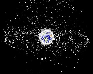
Space debris are defunct human-made objects in space – principally in Earth orbit – which no longer serve a useful function. These include derelict spacecraft – nonfunctional spacecraft and abandoned launch vehicle stages – mission-related debris, and particularly numerous in Earth orbit, fragmentation debris from the breakup of derelict rocket bodies and spacecraft. In addition to derelict human-made objects left in orbit, other examples of space debris include fragments from their disintegration, erosion and collisions or even paint flecks, solidified liquids expelled from spacecraft, and unburned particles from solid rocket motors. Space debris represents a risk to spacecraft.

In satellite laser ranging (SLR) a global network of observation stations measures the round trip time of flight of ultrashort pulses of light to satellites equipped with retroreflectors. This provides instantaneous range measurements of millimeter level precision which can be accumulated to provide accurate measurement of orbits and a host of important scientific data. The laser pulse can also be reflected by the surface of a satellite without a retroreflector, which is used for tracking space debris.

Space warfare is hypothetical combat in which one or more belligerents are situated in outer space. The scope of space warfare therefore includes ground-to-space warfare, such as attacking satellites from the Earth; space-to-space warfare, such as satellites attacking satellites; and space-to-ground warfare, such as satellites attacking Earth-based targets. Space warfare in fiction is thus sub-genre and theme of science fiction, where it is portrayed with a range of realism and plausibility.
The Gravity Recovery and Climate Experiment (GRACE) was a joint mission of NASA and the German Aerospace Center (DLR). Twin satellites took detailed measurements of Earth's gravity field anomalies from its launch in March 2002 to the end of its science mission in October 2017. The GRACE Follow-On (GRACE-FO) is a continuation of the mission on near-identical hardware, launched in May 2018.
Satellite geodesy is geodesy by means of artificial satellites—the measurement of the form and dimensions of Earth, the location of objects on its surface and the figure of the Earth's gravity field by means of artificial satellite techniques. It belongs to the broader field of space geodesy. Traditional astronomical geodesy is not commonly considered a part of satellite geodesy, although there is considerable overlap between the techniques.
Zenit was a series of military photoreconnaissance satellites launched by the Soviet Union between 1961 and 1994. To conceal their nature, all flights were given the public Kosmos designation.

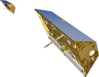
Aeolus, or, in full, Atmospheric Dynamics Mission-Aeolus (ADM-Aeolus), was an Earth observation satellite operated by the European Space Agency (ESA). It was built by Airbus Defence and Space, launched on 22 August 2018, and re-entered the atmosphere over Antarctica in a controlled manner and burned up on 28 July 2023. ADM-Aeolus was the first satellite with equipment capable of performing global wind-component-profile observation and provided much-needed information to improve weather forecasting. Aeolus was the first satellite capable of observing what the winds are doing on Earth, from the surface of the planet and into the stratosphere 30 km high.
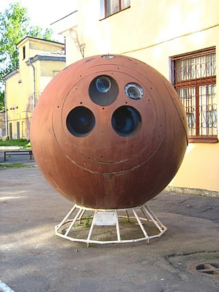
Kosmos 482, launched March 31, 1972, at 04:02:33 UTC, was an attempted Venus probe which failed to escape low Earth orbit. It is expected to crash back to Earth between 2023 and 2025. Its landing module, which weighs 495 kilograms (1,091 lb), is highly likely to reach the surface of Earth in one piece as it was designed to withstand 300 G's of acceleration and 100 atmospheres of pressure.
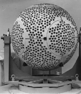
Ajisai is a Japanese satellite sponsored by NASDA, launched in 1986 on the maiden flight of the H-I rocket. It is also known as the Experimental Geodetic Satellite (EGS), as it carries the Experimental Geodetic Payload (EGP).
Kosmos 1818 was a nuclear powered Soviet surveillance satellite in the RORSAT program, which monitored NATO vessels using radar. Kosmos 1818 was the first satellite to use the TOPAZ-1 fission reactor. In July 2008, the satellite was damaged, and leaked a trail of sodium coolant.
Kosmos 1867 is a nuclear powered radar ocean reconnaissance satellite (RORSAT) that was launched by the Soviet Union on July 10, 1987. It was put into an orbit of about 800 km (500 mi). Its mission was to monitor the oceans for naval and merchant vessels, and had a mission life of about eleven months.

STSat-2A was a satellite launched by the Korea Aerospace Research Institute (KARI), the national space agency of South Korea, from the Naro Space Center in Goheung County, South Jeolla using the Naro-1 (KSLV-1) launch vehicle.

LARES is a passive satellite system of the Italian Space Agency.
The Geo-IK-2 is a Russian series of new generation military geodesy satellites replacing the Soviet Union's Geo-IK and Sfera constellations. They are intended to be used to create high precision three-dimensional maps of the Earth's surface, and to monitor plate tectonics. The satellites are produced by ISS Reshetnev, and have a mass of around 1,400 kilograms (3,100 lb). They operate in a circular orbit at an altitude of around 1,000 kilometres (620 mi) above the Earth's surface.
Kosmos 2471, also known as Glonass-K1 No. 11L or Glonass-K No. 701, was a Russian navigation satellite which was launched in 2011. The first Glonass-K satellite to be launched, it was one of two Glonass-K1 spacecraft which served as prototypes for the operational Glonass-K2 spacecraft.
ICESat-2, part of NASA's Earth Observing System, is a satellite mission for measuring ice sheet elevation and sea ice thickness, as well as land topography, vegetation characteristics, and clouds. ICESat-2, a follow-on to the ICESat mission, was launched on 15 September 2018 onboard Delta II as the final flight from Vandenberg Air Force Base in California, into a near-circular, near-polar orbit with an altitude of approximately 496 km (308 mi). It was designed to operate for three years and carry enough propellant for seven years. The satellite orbits Earth at a speed of 6.9 kilometers per second (4.3 mi/s).

GLONASS, also known as Uragan are the first generation of Uragan satellite used as part of the Russian GLONASS radio-based satellite navigation system. Developed by Reshetnev Information Satellite Systems, it had its debut launch on 12 October 1982, with the last launched unit on 25 December 2005 and the retirement of the last unit Kosmos 2403 on 30 April 2009. It has been superseded by the GLONASS-M, the second-generation satellites.

Meteor-3M No.1 was the first and only of the Meteor-3M series polar-orbiting weather satellites. It was launched on 10 December 2001 at 17:18:57 UTC from the Baikonur Cosmodrome in Kazakhstan. The satellite is in a Sun-synchronous orbit with an ascending node time of about 9AM.

Elektron ('electron'), in American sources sometimes called Electron, was the first Soviet multiple satellite program, comprising two identical pairs of particle physics satellites launched by the Soviet Union in 1964. The four spacecraft simultaneously monitored the lower and upper Van Allen radiation belts and returned a considerable volume of data regarding radiation in space and atmospheric conditions to an altitude of more than 58,000 kilometres (36,000 mi) above the Earth. Two of the four launched satellites are still in orbit As of 2023, the other two having reentered.