
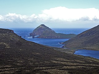
The Auckland Islands are an archipelago of New Zealand, lying 465 km (289 mi) south of the South Island. The main Auckland Island, occupying 460 km2 (180 sq mi), is surrounded by smaller Adams Island, Enderby Island, Disappointment Island, Ewing Island, Rose Island, Dundas Island, and Green Island, with a combined area of 570 km2 (220 sq mi). The islands have no permanent human inhabitants.
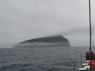
Auckland Island is the main island of the eponymous uninhabited archipelago in the Pacific Ocean. It is part of the New Zealand subantarctic area. It is inscribed in the UNESCO World Heritage list together with the other New Zealand Subantarctic Islands in the region.

The Bounty Islands are a small group of uninhabited granite islets and numerous rocks, with a combined area of circa 50 ha in the South Pacific Ocean. Territorially part of New Zealand, they lie about 670 km (420 mi) east-south-east of New Zealand's South Island, 530 km (330 mi) south-west of the Chatham Islands, and 215 km (134 mi) north of the Antipodes Islands. The group is a World Heritage Site.

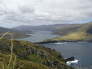
Campbell Island / Motu Ihupuku is an uninhabited subantarctic island of New Zealand, and the main island of the Campbell Island group. It covers 112.68 square kilometres (43.51 sq mi) of the group's 113.31 km2 (43.75 sq mi), and is surrounded by numerous stacks, rocks and islets like Dent Island, Folly Island, Isle de Jeanette-Marie, and Jacquemart Island, the latter being the southernmost extremity of New Zealand. The island is mountainous, rising to over 500 metres (1,640 ft) in the south. A long fiord, Perseverance Harbour, nearly bisects it, opening out to sea on the east coast.

The Snares Islands, known colloquially as The Snares, is a group of uninhabited islands lying about 200 km (120 mi) south of New Zealand's South Island and to the south-southwest of Stewart Island / Rakiura. The Snares consist of the main North East Island and the smaller Broughton Island and Alert Stack, as well as the Western Chain Islands some 5 km (3.1 mi) to the west-southwest. Collectively, the Snares have a total land area of 3.4 km2 (1.3 sq mi).

The Antipodes Islands are inhospitable and uninhabited volcanic islands in subantarctic waters to the south of – and territorially part of – New Zealand. The 21 km2 (8.1 sq mi) archipelago lies 860 km (530 mi) to the southeast of Stewart Island/Rakiura, and 730 km (450 mi) to the northeast of Campbell Island. They are very close to being the antipodal point to Normandy in France, meaning that the city farthest away is Cherbourg-en-Cotentin, France.
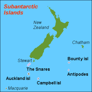
The New Zealand Subantarctic Islands comprise the five southernmost groups of the New Zealand outlying islands. They are collectively designated as a UNESCO World Heritage Site.
The Antipodes Subantarctic Islands tundra ecoregion, within the tundra biome, includes five remote island groups in the Pacific Ocean south of New Zealand: the Bounty Islands, Auckland Islands, Antipodes Islands and Campbell Island groups of New Zealand, and Macquarie Island of Australia.
Jacquemart Island, one of the islets surrounding Campbell Island in New Zealand, lies 1 km south of Campbell Island and is the southernmost island of New Zealand.

The Campbell Islands are a group of subantarctic islands, belonging to New Zealand. They lie about 600 km south of Stewart Island. The islands have a total area of 113 km2 (44 sq mi), consisting of one big island, Campbell Island, and several small islets, notably Dent Island, Isle de Jeanette Marie, Folly Island, Jacquemart Island, and Monowai Island. Ecologically, they are part of the Antipodes Subantarctic Islands tundra ecoregion. The islands are one of five subantarctic island groups collectively designated as a World Heritage Site by UNESCO.

Adams Island is the second largest island of New Zealand's Auckland Islands archipelago.

Enderby Island is part of New Zealand's uninhabited Auckland Islands archipelago, south of mainland New Zealand. It is situated just off the northern tip of Auckland Island, the largest island in the archipelago.
Bollons Island is a small island in New Zealand's subantarctic Antipodes Islands group. It is the second largest island in the group behind Antipodes Island.
The yellow-crowned parakeet also known as the yellow-fronted parakeet is a species of parakeet endemic to the islands of New Zealand. The species is found across the main three islands of New Zealand, North Island, South Island and Stewart Island/Rakiura, as well as on the subantarctic Auckland Islands. It has declined due to predation from introduced species such as stoats, although unlike the red-crowned parakeet, it has not been extirpated from the mainland of New Zealand. Its Māori name is kākāriki.

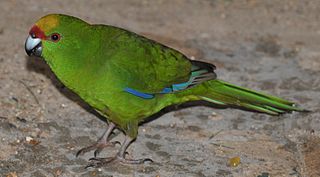
The red-crowned parakeet, also known as red-fronted parakeet and by its Māori name of kākāriki, is a small parrot from New Zealand. It is characterised by its bright green plumage and the red pattern on its head. This versatile bird can feed on a variety food items and can be found in many habitat types. It used to be classified as near threatened as invasive predators had pushed it out of its historical range but it is now at least concern. This species used to occupy the entire island, but is now confined to only a few areas on the mainland and some offshore islands.

Cheeseman Island is a 7.6 ha (19-acre) rocky volcanic island in the southwest Pacific Ocean. It is named after Thomas Frederick Cheeseman of the Auckland Museum, who was on board the New Zealand Government steamer 'Stella' when it visited the island in 1887. It neighbours Curtis Island to the east and lies about 20 km (12 mi) south of Macauley Island. They are part of the Kermadec Islands, an outlying island group of New Zealand, located halfway between New Zealand's North Island and the nation of Tonga.

Disappointment Island is one of seven uninhabited islands in the Auckland Islands archipelago, in New Zealand. It is 475 kilometres (295 mi) south of the country's main South Island and 8 kilometres (5 mi) from the northwest end of Auckland Island. It is home to a large colony of white-capped albatrosses: about 65,000 pairs – nearly the entire world's population – nest there. Also on the island is the Auckland rail, endemic to the archipelago; once thought to be extinct, it was rediscovered in 1966.
Folly Island or the Folly Islands is a subantarctic island located in New Zealand's Campbell Island group.

Port Ross is a natural harbour on Auckland Island in the Auckland Islands Group, a subantarctic chain that forms part of the New Zealand Outlying Islands.
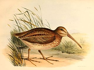
The Auckland snipe, also known as the Auckland Island snipe, is a small bird in the sandpiper family. It is the isolated nominate subspecies of the subantarctic snipe that is endemic to the Auckland Islands, a subantarctic island group south of New Zealand in the Southern Ocean.

