
Docklands is an inner-city suburb in Melbourne, Victoria, Australia, 2 km (1.2 mi) west of Melbourne's Central Business District, located within the City of Melbourne local government area. Docklands recorded a population of 15,495 at the 2021 census.

This is a timeline of major events in the history of the city of Melbourne, Australia.

CityLink is a network of tollways in Melbourne, Australia, linking the Tullamarine, West Gate and Monash Freeways and incorporating Bolte Bridge, Burnley Tunnel and other works. In 1996, Transurban was awarded the contract to augment two existing freeways and construct two new toll roads – labelled the Western and Southern Links– directly linking a number of existing freeways to provide a continuous, high-capacity road route to, and around, the central business district. CityLink uses a free-flow tolling electronic toll collection system, called e-TAG. CityLink is currently maintained by Lendlease Services.
Hoddle Grid is the contemporary name given to the approximately 1-by-0.5-mile grid of streets that form the Melbourne central business district, Australia. Bounded by Flinders Street, Spring Street, La Trobe Street, and Spencer Street, it lies at an angle to the rest of the Melbourne suburban grid, and so is easily recognisable. It is named after the surveyor Robert Hoddle, who marked it out in 1837, establishing the first formal town plan. This grid of streets, laid out when there were only a few hundred settlers, became the nucleus for what is now Melbourne, a city of over five million people.

Newport is a suburb in Melbourne, Victoria, Australia, 10 km (6.2 mi) south-west of Melbourne's Central Business District, located within the City of Hobsons Bay local government area. Newport recorded a population of 13,658 at the 2021 census.
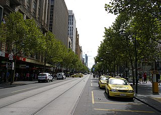
Swanston Street is a major thoroughfare in the centre of Melbourne, Victoria, Australia. It is one of the main streets of the Melbourne central business district and was laid out in 1837 as part of the original Hoddle Grid. The street vertically bisects Melbourne's city centre and is famous as the world's busiest tram corridor, for its heritage buildings and as a shopping strip.

Collins Street is a major street in the central business district of Melbourne, Victoria, Australia. It was laid out in the first survey of Melbourne, the original 1837 Hoddle Grid, and soon became the most desired address in the city. Collins Street was named after Lieutenant-Governor of Tasmania David Collins who led a group of settlers in establishing a short-lived settlement at Sorrento in 1803.

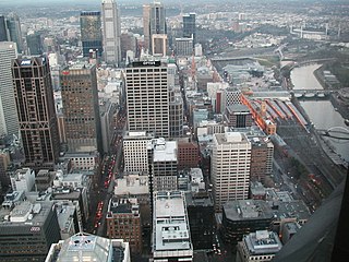
Flinders Street is a street in Melbourne, Victoria, Australia. Running roughly parallel to the Yarra River, Flinders Street forms the southern edge of the Hoddle Grid. It is exactly 1 mi (1.609 km) in length and one and a half chains in width. It is named for the explorer Matthew Flinders, erroneously credited with discovering Port Phillip at the time of its naming. It extends eastwards as far as Spring Street and the Treasury Gardens and westwards past Batman's Hill to the Melbourne Docklands. As the closest street to the river, Flinders Street serviced Melbourne's original river port. Customs House, now the site for Victoria's Immigration Museum, is on Flinders Street.

Melbourne tram route 70 is operated by Yarra Trams on the Melbourne tram network from Waterfront City to Wattle Park. The 16.5 kilometre route is operated out of Camberwell depot with A and B class trams.
Batman's Hill in Melbourne, Australia was named for the Vandemonian adventurer and grazier John Batman. Now removed, the 18-metre-high hill was located to the south of today's Collins Street and Southern Cross railway station, and is the site of a steel marker the same height as the original hill.

Spring Street is a major street in the central business district of Melbourne, Australia. It runs roughly north-south and is the easternmost street in the original 1837 Hoddle Grid.
King Street is a main road in the central business district of Melbourne, Australia. It is considered a key hub of Melbourne's nightlife and is home to many pubs, nightclubs, restaurants, and adult entertainment venues.

The City Square was a public plaza located in the Central Business District (CBD) of Melbourne, Victoria, Australia. The site is currently bounded by Swanston Street, Collins Street, Flinders Lane and the Westin Hotel. The historic landmarks of Melbourne Town Hall and St Paul’s Cathedral are across the streets to the north and south respectively. The square has been redeveloped several times and associated with a number of controversies over the years.

Centre Place is a laneway and pedestrian precinct in Melbourne, Australia. It runs north from Flinders Lane to Collins Street, between Elizabeth Street and Swanston Street.

The Melbourne central business district is the city centre and main urban area of the city of Melbourne, Victoria, Australia, centred on the Hoddle Grid, the oldest part of the city laid out in 1837, and includes its fringes. The Melbourne CBD is located in the local government area of the City of Melbourne which also includes some of inner suburbs adjoining the CBD.

Flinders Lane is a minor street and thoroughfare in the central business district of Melbourne, Victoria, Australia. The laneway runs east–west from Spring Street to Spencer Street in-between Flinders and Collins Streets. Originally laid out as part of the Hoddle Grid in 1837, the laneway was once the centre of Melbourne's rag trade and is still home to boutique designers and high-end retailers including Chanel, now perched alongside numerous upscale hotels like the W Hotel Melbourne and Adelphi Hotel, loft apartments, cafes and bars.

Jolimont Yard was an array of railway lines and carriage sidings on the edge of the central business district of Melbourne, Australia. Located between Flinders Street station, Richmond Junction, the Yarra River and Flinders Street they were often criticised for cutting off the city from the river, being the site of many redevelopment proposals. The Princes Gate Towers were built over part of the yard in the 1960s, which themselves were replaced by Federation Square in the 1990s. The rail sidings themselves were progressively removed from the 1980s to the 1990s with only running lines today, but the area continues to be referred to as the 'Jolimont railyards' by Melburnians.

Batman Park is an urban park, located on the northern bank of the Yarra River in central Melbourne, Victoria, Australia.

St. Collins Lane is a shopping centre completed in 2016, designed by ARM Architecture, which stretches between Collins and Little Collins streets in Melbourne, Australia. Previously there were restaurants, arcades and hotels on the site.
Melbourne, the capital of Victoria, Australia, was an important Victorian-era city and erected "some of the world's most majestic buildings" of the era. Several buildings survive from the period, including the State Library of Victoria (1856), Parliament House (1856), the General Post Office, the Royal Exhibition Building (1880), the Windsor Hotel (1884), the Block Arcade (1893), and the Rialto Building Group (1888–1891). However, many of the well-known architectural gems of Melbourne's Victorian central city were demolished in the 20th-century. Some were lost in preparation for the 1956 Summer Olympics when Melbourne sought to reinvent itself as a modern, post-war city. Whelan's or Whelan the Wrecker was a well-known demolition company that was responsible for at least thirty of these demolitions, many at the instruction of the Melbourne City Council.


