A braided river consists of a network of river channels separated by small, often temporary, islands called braid bars or, in British English usage, aits or eyots.

Iniidae is a family of river dolphins containing one living genus, Inia, and four extinct genera. The extant genus inhabits the river basins of South America, but the family formerly had a wider presence across the Atlantic Ocean.
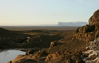
An outwash plain, also called a sandur, sandr or sandar, is a plain formed of glaciofluvial deposits due to meltwater outwash at the terminus of a glacier. As it flows, the glacier grinds the underlying rock surface and carries the debris along. The meltwater at the snout of the glacier deposits its load of sediment over the outwash plain, with larger boulders being deposited near the terminal moraine, and smaller particles travelling further before being deposited. Sandurs are common in Iceland where geothermal activity accelerates the melting of ice flows and the deposition of sediment by meltwater.

The Dytiscidae – based on the Greek dytikos (δυτικός), "able to dive" – are the predaceous diving beetles, a family of water beetles. They occur in virtually any freshwater habitat around the world, but a few species live among leaf litter. The adults of most are between 1 and 2.5 cm (0.4–1.0 in) long, though much variation is seen between species. The European Dytiscus latissimus and Brazilian Megadytes ducalis are the largest, reaching up to 4.5 and 4.75 cm respectively. In contrast, the smallest is likely the Australian Limbodessus atypicali of subterranean waters, which only is about 0.9 mm (0.035 in) long. Most are dark brown, blackish, or dark olive in color with golden highlights in some subfamilies. The larvae are commonly known as water tigers due to their voracious appetite. They have short, but sharp mandibles and immediately upon biting, they deliver digestive enzymes into prey to suck their liquefied remains. The family includes more than 4,000 described species in numerous genera.
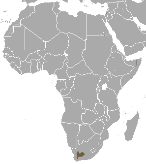
The riverine rabbit, also known as the bushman rabbit or bushman hare, is a rabbit with an extremely limited distribution area, found only in the central and southern regions of the Karoo Desert of South Africa's Northern Cape Province. It is the only member of the genus Bunolagus because of unique traits that separate it from the other leporids. It is one of the most endangered mammals in the world, with only around 500 living adults, and 1500 overall.

The greater horseshoe bat is an insectivorous bat of the genus Rhinolophus. Its distribution covers Europe, Northern Africa, Central Asia and Eastern Asia. It is the largest of the horseshoe bats in Europe and is thus easily distinguished from other species. The species is sedentary, typically travelling up to 30 kilometres (19 mi) between the winter and summer roosts, with the longest recorded movement being 180 km (110 mi). The frequencies used by this bat species for echolocation lie between 69–83 kHz, have most energy at 81 kHz and have an average duration of 37.4 ms.
A wide variety of river and stream channel types exist in limnology, the study of inland waters. All these can be divided into two groups by using the water-flow gradient as either low gradient channels for streams or rivers with less than two percent (2%) flow gradient, or high gradient channels for those with greater than a 2% gradient.

Manas National Park is a national park, Project Tiger reserve, and an elephant reserve in Assam, India. Located in the Himalayan foothills, it borders the Royal Manas National Park in Bhutan. The park is known for its rare and endangered endemic wildlife such as the Assam roofed turtle, hispid hare, golden langur and pygmy hog. It also hosts the only known population of pygmy hogs in the world. Manas is also famous for its population of the wild water buffalo. Because of its exceptional biodiversity, scenery, and variety of habitats, Manas National Park is a biosphere reserve and a UNESCO World Heritage Site.

Intermittent, temporary or seasonal rivers or streams cease to flow every year or at least twice every five years. Such rivers drain large arid and semi-arid areas, covering approximately a third of the Earth's surface. The extent of temporary rivers is increasing, as many formerly perennial rivers are becoming temporary because of increasing water demand, particularly for irrigation. Despite inconsistent water flow, intermittent rivers are considered land-forming agents in arid regions, as they are agents of significant deposition and erosion during flood events. The combination of dry crusted soils and the highly erosive energy of the rain cause sediment resuspension and transport to the coastal areas. They are among the aquatic habitats most altered by human activities. During the summer even under no flow conditions the point sources are still active such as the wastewater effluents, resulting in nutrients and organic pollutants accumulating in the sediment. Sediment operates as a pollution inventory and pollutants are moved to the next basin with the first flush. Their vulnerability is intensified by the conflict between water use demand and aquatic ecosystem conservation. Advanced modelling tools have been developed to better describe intermittent flow dynamic changes such as the tempQsim model.
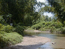
Washdyke Lagoon is a brackish shallow coastal lagoon approximately 1 kilometre (0.62 mi) north of Timaru, South Canterbury, New Zealand. The lagoon has drastically reduced in size since 1881 when it was approximately 253 hectares, now it is less than 48 hectares (0.48 km2) in area. It is enclosed by a barrier beach that is 3 kilometres (1.9 mi) long and 3 metres (9.8 ft) above high tide at its largest point. The reduced lagoon size is due to the construction of the Timaru Port breakwater which is preventing coarse sediments from reaching and replenishing Washdyke Barrier. This is important as the lagoon and the surrounding 250 hectares are classified as a wildlife refuge and it demonstrates the role human structures have on coastline evolution.
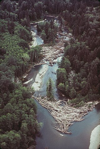
A log jam is a naturally occurring phenomenon characterized by a dense accumulation of tree trunks and pieces of large wood across a vast section of a river, stream, or lake. Log jams in rivers and streams often span the entirety of the water's surface from bank to bank. Log jams form when trees floating in the water become entangled with other trees floating in the water or become snagged on rocks, large woody debris, or other objects anchored underwater. They can build up slowly over months or years, or they can happen instantaneously when large numbers of trees are swept into the water after natural disasters. A notable example caused by a natural disaster is the log jam that occurred in Spirit Lake following a landslide triggered by the eruption of Mount St. Helens. Unless they are dismantled by natural causes or humans, log jams can grow quickly, as more wood arriving from upstream becomes entangled in the mass. Log jams can persist for many decades, as is the case with the log jam in Spirit Lake.

The Cosumnes River Preserve is a nature preserve of over 51,000 acres (210 km2) located 20 miles (30 km) south of Sacramento, in the US state of California. The preserve protects a Central Valley remnant that once contained one of the largest expanses of oak tree savanna, riparian oak forest and wetland habitat in North America. Agricultural development has changed the landscape from groves of oaks and tule marshes to productive farmlands.

The Brigalow Belt is a wide band of acacia-wooded grassland that runs between tropical rainforest of the coast and the semi-arid interior of Queensland and northern New South Wales, Australia. The Interim Biogeographic Regionalisation for Australia (IBRA) divides the Brigalow Belt into two IBRA regions, or bioregions, Brigalow Belt North (BBN) and Brigalow Belt South (BBS). The North and South Brigalow Belt are two of the 85 bioregions across Australia and the 15 bioregions in Queensland. Together they form most of the Brigalow tropical savanna ecoregion.

The Molteno Formation is a geological formation found in several localities in Lesotho and South Africa. It lies mainly south of Maseru, near Burgersdorp, Aliwal North, Dordrecht, Molteno, and Elliot. It extends as far north as Matatiele in the Eastern Cape. The formation's localities lie along the Drakensberg Mountains in Kwazulu-Natal, and near Ladybrand in the Free State of South Africa. The Molteno Formation is the lowermost of the three formations in the Stormberg Group of the greater Karoo Supergroup. The Molteno Formation represents the initial phase of preserved sedimentation of the Stormberg Group.

Braid bars, or mid-channel bars, are river landforms typically present in braided river channels. These formations have many names, including medial, longitudinal, crescentic, and transverse bars, as well as the more colloquial sandflat. Braid bars are distinguished from point bars due to their presence in the middle of a flow channel, rather than along a bank of the river channel.

The flood pulse concept explains how the periodic inundation and drought control the lateral exchange of water, nutrients and organisms between the main river channel and the connected floodplain. The annual flood pulse is the most important aspect and the most biologically productive feature of a river's ecosystem. describing the movement, distribution and quality of water in river ecosystems and the dynamic interaction in the transition zone between water and land. It contrasts with previous ecological theories which considered floods to be catastrophic events.

The island of Borneo is located on the Sunda Shelf, which is an extensive region in Southeast Asia of immense importance in terms of biodiversity, biogeography and phylogeography of fauna and flora that had attracted Alfred Russel Wallace and other biologists from all over the world.
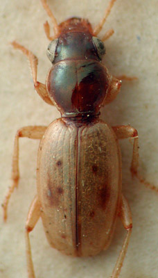
The Back Beach beetle is a small critically endangered species of ground beetle, found only in the intertidal sand of Back Beach, a small sandspit near Nelson, New Zealand.

The marine ecoregions of the South African exclusive economic zone are a set of geographically delineated regions of similar ecological characteristics on a fairly broad scale, covering the exclusive economic zone along the South African coast.