Samoa, officially the Independent State ofSamoa and until 1997 known as Western Samoa, is an island country consisting of two main islands, Savai'i and Upolu, two smaller inhabited islands, Manono and Apolima, and several small uninhabited islands including the Aleipata Islands. The capital city is Apia. The Lapita people discovered and settled the Samoan Islands around 3,500 years ago. They developed a Samoan language and Samoan cultural identity.

Politics of Samoa takes place in a framework of a parliamentary representative democratic state whereby the Prime Minister of Samoa is the head of government. Existing alongside the country's Western styled political system is the fa'amatai chiefly system of socio-political governance and organisation, central to understanding Samoa's political system.

Savaiʻi is the largest and highest island in Samoa and the Samoan Islands chain. The island is the sixth largest in Polynesia, behind the three main islands of New Zealand and the Hawaiian Islands of Hawaii and Maui.

Salelologa is a village district at the east end of Savai'i island in Samoa. It is the main entry point into the island with the only ferry terminal on Savai'i. It also serves as the main township for shopping and public amenities with a market selling fresh produce and arts and crafts.
Samoa is made up of eleven itūmālō. These are the traditional eleven districts that were established well before European arrival. Each district has its own constitutional foundation (faavae) based on the traditional order of title precedence found in each district's faalupega.

Aiga-i-le-Tai is a district of Samoa which includes the small islands of Manono, Apolima and tiny uninhabited Nu'ulopa lying in the Apolima Strait between the country's two main islands of Upolu and Savai'i.

Ancient Principality of Samoa.

Gaga'emauga is a district on the island of Savai'i in Samoa. The district is situated on the central north side of Savai'i. The name Gaga'emauga literally means "near side of the mountain", meaning the eastern side of the mountain chain running through the centre of Savai'i Island.

Tuamāsaga is a district of Samoa, with a population of 95,907. The geographic area of Tuamasaga covers the central part of Upolu island.

Susuga Malietoa Tanumafili I was the Malietoa in Samoa from 1898 until his death in 1939.
Le Susuga Malietoa Talavou Tonumaipe’a was installed as "King" of Samoa to the western world on August 28, 1879 until his death on November 9, 1880. Since Malietoa Talavou's half brother's death, Malietoa Moli in 1860, ongoing wars due to power and authority struggle between Talavou and Laupepa over the next Malietoa title holder and the gaining of support by the districts of Samoa. Family rivalry existed as did a 30-year age difference drew a wedge between Malietoa Laupepa and Malietoa Talavou. They were known to be longtime rivals over the Malietoa title.

Mālietoa is a state dynasty and chiefly title in Samoa. Literally translated as "great warrior", the title's origin comes from the final words of the Tongan warriors as they were fleeing on the beach to their boats, "Malie To`a, Malo e tau...".

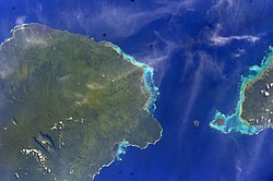
The Apolima Strait is about 13 km wide and separates the two largest islands of Samoa, the island of Savai'i to the northwest, and Upolu to the southeast.

Safotulafai is a traditional village at the east end of Savai'i island with historical and political significance in Samoa's history. It is the traditional center of the island of Savaii, now became the center of Fa'asaleleaga political district.

Lauaki Namulau'ulu Mamoe was a renowned orator chief and the first leader of the Mau, a resistance movement in Samoa during colonialism. Mamoe was exiled to Saipan in 1909. He died in 1915 as he was taken back to Samoa.

Sapapali'i is a village on the north east coast of Savai'i island in Samoa. It is the village where John Williams, the first missionary to bring Christianity to Samoa landed in 1830. Sapapali'i is in the Fa'asaleleaga political district.
Tuasivi is a village situated on the north east coast of Savai'i island in Samoa. The village is in the electoral political district of Fa'asaleleaga.
Fogapoa is a village on the north east coast of Savai'i island in Samoa. The village is part of the electoral constituency Fa'asaleleaga II which is within the larger political district (Itumalo) of Fa'asaleleaga.

Fatausi is a village on the north east coast of Savai'i Island in the Independent State of Samoa.