
The Pennsylvania Turnpike, sometimes shortened to Penna Turnpike or PA Turnpike, is a controlled-access toll road which is operated by the Pennsylvania Turnpike Commission (PTC) in Pennsylvania. It runs for 360 miles (580 km) across the southern part of the state, connecting Pittsburgh and Philadelphia, and passes through four tunnels as it crosses the Appalachian Mountains. A component of the Interstate Highway System, it is part of Interstate 76 (I-76) between the Ohio state line and Valley Forge. I-70 runs concurrently with I-76 between New Stanton and Breezewood, Interstate 276 (I-276) between Valley Forge and Bristol Township, and I-95 from Bristol Township to the New Jersey state line.

Interstate 83 (I-83) is an Interstate Highway located in the states of Maryland and Pennsylvania in the Eastern United States. Its southern terminus is at a signalized intersection with Fayette Street in Baltimore, Maryland; its northern terminus is at I-81 near Harrisburg, Pennsylvania. I-83 runs from Downtown Baltimore north to I-695 near the northern suburb of Timonium on the Jones Falls Expressway before forming a concurrency with I-695. After splitting from I-695, the route follows the Baltimore–Harrisburg Expressway north to the border between Maryland and Pennsylvania. Upon crossing the state line, I-83 becomes the Veterans of Foreign Wars of the United States Memorial Highway and continues north through York toward the Harrisburg area. The route runs along the southern and eastern portion of the Capital Beltway that encircles Harrisburg before reaching its northern terminus.

Fallston is a borough in Beaver County, Pennsylvania, United States, along the Beaver River. The population was 259 at the 2020 census. It is a part of the Pittsburgh metropolitan area.
The Blue Water Bridge is a twin-span international bridge across the St. Clair River that links Port Huron, Michigan, United States, and Point Edward, Ontario, Canada. The Blue Water Bridge connects Highway 402 in Ontario with both Interstate 69 (I-69) and Interstate 94 (I-94) in Michigan.
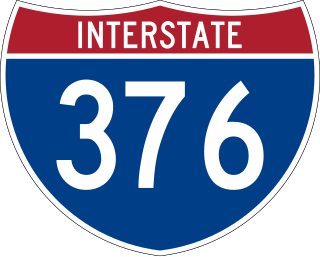
Interstate 376 (I-376) is a major auxiliary route of the Interstate Highway System in the US state of Pennsylvania, located within the Allegheny Plateau. It runs from I-80 near Sharon south and east to a junction with the Pennsylvania Turnpike in Monroeville, after having crossed the Pennsylvania Turnpike at an interchange in Big Beaver. The route serves Pittsburgh and its surrounding areas and is the main access road to Pittsburgh International Airport (PIT). Portions of the route are known as the Beaver Valley Expressway, Southern Expressway, and Airport Parkway. Within Allegheny County, the route runs along the majority of the Penn-Lincoln Parkway, known locally as Parkway West and Parkway East. It is currently the ninth-longest auxiliary Interstate route in the system and second only to I-476 within Pennsylvania.

The Calhoun Street Toll Supported Bridge is a historic bridge connecting Calhoun Street in Trenton, New Jersey across the Delaware River to East Trenton Avenue in Morrisville, Bucks County, Pennsylvania, United States. It was constructed by the Phoenix Bridge Company of Phoenixville, Pennsylvania, in 1884, replacing an earlier bridge built in 1861. The bridge was part of the Lincoln Highway until 1920, and was later connected to Brunswick Circle by the Calhoun Street Extension as part of a bypass of downtown Trenton. Before 1940, trolleys of the Trenton-Princeton Traction Company, utilized this bridge to cross into Pennsylvania. The bridge is owned by the Delaware River Joint Toll Bridge Commission, and is maintained with tolls from other bridges. It carries Light vehicle traffic, and streetcars until 1940.

The Columbia–Wrightsville Bridge, officially the Veterans Memorial Bridge, spans the Susquehanna River between Columbia and Wrightsville, Pennsylvania, and carries Pennsylvania Route 462 and BicyclePA Route S. Built originally as the Lancaster-York Intercounty Bridge, construction began in 1929, and the bridge opened September 30, 1930. On November 11, 1980, it was officially dedicated as Veterans Memorial Bridge, though it is still referenced locally as the Columbia–Wrightsville Bridge.

The Delaware River–Turnpike Toll Bridge is a four-lane, steel through arch bridge crossing the Delaware River between Burlington Township, Burlington County, New Jersey and Bristol Township, Bucks County, Pennsylvania, United States. As a part of Interstate 95 (I-95), it is a major highway link between Philadelphia and New York City. The bridge also connects the Pennsylvania Turnpike's east-west mainline with the main trunk of the New Jersey Turnpike, via the Pearl Harbor Memorial Turnpike Extension. Tolls are collected only in the west/southbound direction via electronic toll collection.

U.S. Route 30 (US 30) is a United States Numbered Highway that runs east–west across the southern part of Pennsylvania, passing through Pittsburgh and Philadelphia on its way from the West Virginia state line east to the Benjamin Franklin Bridge over the Delaware River into New Jersey.

The Liberty Bridge, which was completed in 1928, connects downtown Pittsburgh, Pennsylvania, to the Liberty Tunnels and the South Hills neighborhoods beyond. It crosses the Monongahela River and intersects Interstate 579 at its northern terminus.

The Market Street Bridge is a stone arch bridge that spans the Susquehanna River between Harrisburg, Pennsylvania, and Wormleysburg, Pennsylvania. The current structure is the third bridge built at its current location and is the second oldest remaining bridge in Harrisburg. The bridge carries BicyclePA Route J across the river.

Pennsylvania Route 652 is a 10.559-mile-long (16.993 km) east–west state highway located in the northeast Pennsylvania county of Wayne. The western terminus of the route is at U.S. Route 6 in the Texas Township community of Indian Orchard. The highways heads to the northeast, and reaches the eastern terminus at the New York-Pennsylvania border in Damascus Township, where PA 652 crosses the Narrowsburg–Darbytown Bridge over the Delaware River and into New York, continuing as New York State Route 52 and County Route 24 in Sullivan County.
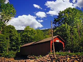
The Sonestown Covered Bridge is a covered bridge over Muncy Creek in Davidson Township, Sullivan County, Pennsylvania built around 1850. It is 110 ft (34 m) long and was placed on the National Register of Historic Places (NRHP) in 1980. It is named for the nearby unincorporated village of Sonestown in Davidson Township, and is also known as the Davidson Covered Bridge. It was built to provide access to a grist mill which operated until the early 20th century.

The Forksville Covered Bridge is a Burr arch truss covered bridge over Loyalsock Creek in the borough of Forksville, Sullivan County, in the U.S. state of Pennsylvania. It was built in 1850 and is 152 feet 11 inches (46.61 m) in length. The bridge was placed on the National Register of Historic Places in 1980. The Forksville bridge is named for the borough it is in, which in turn is named for its location at the confluence or "forks" of the Little Loyalsock and Loyalsock Creeks.
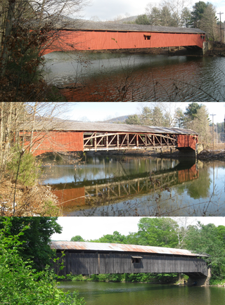
The Hillsgrove Covered Bridge is a Burr arch truss covered bridge over Loyalsock Creek in Hillsgrove Township, Sullivan County, in the U.S. state of Pennsylvania. It was built c. 1850 and is 186 feet (56.7 m) long. In 1973, it became the first covered bridge in the county to be placed on the National Register of Historic Places (NRHP). The bridge is named for the township and nearby unincorporated village of Hillsgrove, and is also known as Rinkers Covered Bridge for an adjoining farm.

The Strawberry Mansion Bridge is a steel arch truss bridge across the Schuylkill River in Fairmount Park in Philadelphia, Pennsylvania.

The Washington Crossing Bridge, commonly known as the Fortieth Street Bridge, is an arch bridge that carries vehicular traffic across the Allegheny River between the Pittsburgh neighborhood of Lawrenceville and the suburb of Millvale. The bridge is decorated with the seals representing the original 13 colonies of the US and that of Allegheny county.

The Brownsville Bridge, also known as the Intercounty Bridge and the West Brownsville Bridge, is a truss bridge that carries vehicular traffic across the Monongahela River between Brownsville, Pennsylvania and West Brownsville, Pennsylvania. Since the opening of the Lane Bane Bridge and highway project to carry much of the intercounty through traffic away from the main streets of downtown Brownsville in the early 1960s, another commonly heard name is Old Brownsville Bridge for the four high level viaduct.

The Ocean-to-Ocean Bridge is a through truss bridge spanning the Colorado River in Yuma, Arizona. Built in 1915, it was the first highway crossing of the lower Colorado and is the earliest example of a through truss bridge in Arizona. It is also the only example of a Pennsylvania truss within Arizona. Originally the bridge carried the transcontinental Ocean-to-Ocean Highway and later carried its successor, US 80 until a new bridge was built to the west in 1956. Between 1988 and 2001, the bridge was closed to vehicular traffic and only traversable by pedestrians and bicyclists. After a major restoration, the bridge was rehabilitated and reopened to vehicular traffic in 2002, with a re-dedication by the Quechan nation and Yuma Crossing National Heritage Area. The bridge became part of Historic US 80 in 2018.

