Farmer City, Kansas

Last updated

Farmer City, Kansas
Map of Wichita Co, Ks, USA.png
USA Kansas location map.svg
Red pog.svg
Farmer City
Usa edcp location map.svg
Red pog.svg
Farmer City
Coordinates: 38°17′8″N101°11′35″W / 38.28556°N 101.19306°W / 38.28556; -101.19306
Country United States
State Kansas
County Wichita
Population
  Total
0
Time zone UTC-6 (CST)
  Summer (DST) UTC-5 (CDT)
Area code 620

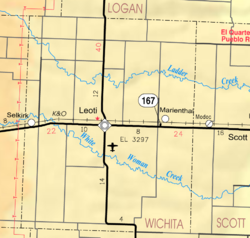
Farmer City is a ghost town in Wichita County, Kansas, United States.

Contents

History

It was hoped that it would become the county seat — a compromise between the fighting towns of Leoti and Coronado. Soon after Leoti won the fight, Farmer City and most of Coronado vanished.

References

    Further reading