
The River Liffey is a river in eastern Ireland that ultimately flows through the centre of Dublin to its mouth within Dublin Bay. Its major tributaries include the River Dodder, the River Poddle and the River Camac. The river supplies much of Dublin's water and supports a range of recreational activities.

The Northside in an informal but commonly used term to describe the part of the city of Dublin that lies to the north of the River Liffey, and extending into part of North County Dublin. The part outside the city is within the county of Fingal, a local government area established in 1994. While it is sometimes regarded as less wealthy than the city's Southside, the Northside was originally the home of the city's upper classes and the more privileged of the two. Today, some of the wealthiest areas in Ireland, such as Malahide, Howth, Clontarf, and Castleknock, lie north of the river.

The Tom Clarke Bridge, formerly and commonly known as the East-Link Toll Bridge, is a toll bridge in Dublin, Ireland, on the River Liffey, owned and operated by Dublin City Council. The bascule-type lifting bridge, which links North Wall to Ringsend, is the last bridge on the Liffey, which opens out into Dublin Port and then Dublin Bay just beyond. The bridge forms part of the R131 regional road.

The Ha'penny Bridge, known later for a time as the Penny Ha'penny Bridge, and officially the Liffey Bridge, is a pedestrian bridge built in May 1816 over the River Liffey in Dublin, Ireland. Made of cast iron, the bridge was cast in Shropshire, England.

Farmleigh is the official Irish state guest house. It was formerly one of the Dublin residences of the Guinness family. It is situated on an elevated position above the River Liffey to the northwest of the Phoenix Park, in Castleknock. The estate of 78 acres (32 ha) consists of extensive private gardens with stands of mature cypress, pine and oak trees, a boating pond, walled garden, sunken garden, out offices and a herd of rare native Kerry cattle. It was purchased by the Government of Ireland from Edward Guinness, 4th Earl of Iveagh in 1999 for €29.2 million. A state body—the Office of Public Works (OPW)—spent in the region of €23 million restoring the house, gardens and curvilinear glasshouses, bringing the total cost to the state to €52.2 million. Farmleigh was opened to the public in July 2001.

Dublin Port is the seaport of Dublin, Ireland, of both historical and contemporary economic importance. Approximately two-thirds of Ireland's port traffic travels via the port, which is by far the busiest on the island of Ireland.

The West-Link is a toll bridge on the M50 motorway to the west of Dublin, Ireland, operated by Emovis for Transport Infrastructure Ireland.

Rachel Joynt is an Irish sculptor who has created some prominent Irish public art. She graduated from the National College of Art and Design in Dublin in 1989 with a degree in sculpture.
The Loopline Bridge is a railway bridge spanning the River Liffey and several streets in Dublin, Ireland. It joins rail services from south of Dublin to Connolly Station and lines north.

Father Mathew Bridge is a road bridge spanning the River Liffey in Dublin, Ireland, which joins Merchants Quay to Church Street and the north quays. It occupies the approximate site of the original and for many years the only, Bridge of Dublin, dating back to the 11th century.

Transport 21 was an Irish infrastructure plan, announced in November 2005. Its aims were to greatly expand Ireland's transport network. A cost estimate of €34 billion was attached to the plan at the time.

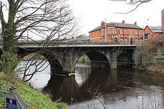
Lucan Bridge is a road bridge spanning the River Liffey in Lucan, County Dublin, Ireland. It joins Lucan's Main Street to the Lower Lucan Road, carrying traffic towards Clonsilla and the north, and the Strawberry Beds to the east. Designed by George Knowles, it was built in 1814. Constructed in collaboration with James Savage at a cost of more than £9,000, it replaced several previous bridges which had been carried away by floods.
The Anna Livia Bridge, formerly Chapelizod Bridge, is a road bridge spanning the River Liffey in Chapelizod, Dublin, Ireland which joins the Lucan Road to Chapelizod Road.

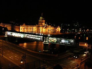
The Dublin quays refers to the two roadways and quays that run along the north and south banks of the River Liffey in Dublin, Ireland. The stretches of the two continuous streets have several different names. However, all but two of the names share the same "quay" designation. The quays have played an important part in Dublin's history.

The Broadmeadow viaduct is a rail bridge carrying the main Dublin to Belfast railway across the estuary of the Broadmeadow River, about 13 kilometres north of Dublin, Ireland. Just north of Malahide village, it is approximately 180 metres (590 ft) long and is a section of a longer crossing constructed as an embankment. The viaduct carries around ninety trains, including commuter services and heavy freight, per day and it is the sole rail route between Dublin and Belfast. It has had a history of problems with its foundations being scoured out by strong currents.
Clonsilla or "Clonsillagh" is a civil parish and a townland located in the south-western corner of the modern county of Fingal, Ireland. The civil parish is part of the ancient barony of Castleknock. It is centred on the suburban village of Clonsilla. In geology, the parish rests on a substratum of limestone and comprises 2943 statute acres, the whole of which is arable land. It is roughly bounded to the north by the old "Navan Road" – the modern N3; to the east by the civil parish of Castleknock; to the south by the River Liffey; to the south-east by the civil parish of Leixlip, chiefly in County Kildare, and to the north-west by the civil parish of Dunboyne in County Meath.
Strawberry Beds or The Strawberry Beds is a locality and small settlement 7 km to the west of Dublin City, Ireland, located on the northern banks of the River Liffey between Chapelizod and Lucan where the closest bridges span the river. The populated suburb of Palmerstown lies just south of the Strawberry Beds, but is inaccessible due to the Liffey which separates them. The R109 road, also known as the 'Lower Road' for the section between Chapelizod and Lucan, is the only road that passes through the Strawberry Beds. The area is protected by a Special Amenity Area Order (SAAO).

