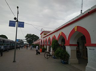
Fazilka railway station

Last updated

Fazilka Junction
Indian Railway Junction Station
LocationCycle Market Road, Fazilka, Punjab
India
Coordinates 30°24′32″N74°01′30″E / 30.409°N 74.025°E / 30.409; 74.025 Coordinates: 30°24′32″N74°01′30″E / 30.409°N 74.025°E / 30.409; 74.025
Elevation181 metres (594 ft)
Owned by Indian Railways
Operated by Northern Railway
Line(s) Ludhiana-Fazilka line
Delhi-Fazilka line
Abohar-Fazilka line
Platforms2
Tracks Broad gauge 1,676 mm (5 ft 6 in)
Construction
Structure typeStandard on ground
ParkingYes
Bicycle facilitiesNo
Other information
StatusFunctioning
Station codeFKA
Division(s) Firozpur
History
Opened1897
Location
India Punjab location map.svg
Red pog.svg
Fazilka Junction railway station
Location in Punjab

Fazilka Junction is located in Fazilka district in the Indian state of Punjab and serves Fazilka. It is a defunct rail transit point on the India-Pakistan border.

Fazilka district District in Punjab, India

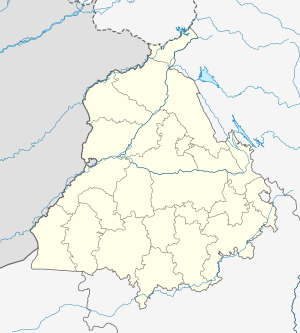
Fazilka district is one of new and 22 districts in the state of Punjab in India.

India Country in South Asia

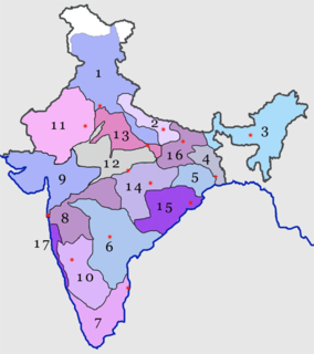
India is a country in South Asia. It is the seventh-largest country by area, the second-most populous country, and the most populous democracy in the world. Bounded by the Indian Ocean on the south, the Arabian Sea on the southwest, and the Bay of Bengal on the southeast, it shares land borders with Pakistan to the west; China, Nepal, and Bhutan to the north; and Bangladesh and Myanmar to the east. In the Indian Ocean, India is in the vicinity of Sri Lanka and the Maldives; its Andaman and Nicobar Islands share a maritime border with Thailand and Indonesia.

Punjab, India State in Northern India

Punjab is a state in northern India. Forming part of the larger Punjab region of the Indian subcontinent, the state is bordered by the Indian states of Jammu and Kashmir to the north, Himachal Pradesh to the east, Haryana to the south and southeast, Rajasthan to the southwest, and the Pakistani province of Punjab to the west. The state covers an area of 50,362 square kilometres, 1.53% of India's total geographical area. It is the 20th-largest Indian state by area. With 27,704,236 inhabitants at the 2011 census, Punjab is the 16th-largest state by population, comprising 22 districts. Punjabi is the most widely spoken and official language of the state. The main ethnic group are the Punjabis, with Sikhs (58%) and Hindus (38%). The state capital is Chandigarh, a Union Territory and also the capital of the neighbouring state of Haryana. The five tributary rivers of the Indus River from which the region took its name are Sutlej, Ravi, Beas, Chenab and Jhelum Rivers; Sutlej, Ravi and Beas are part of the Indian Punjab.

Contents

The railway station

Fazilka railway station is at an elevation of 181 metres (594 ft) and was assigned the code – FKA. [1]

History

The Southern Punjab Railway Co. opened the Delhi-Bhatinda-Samasatta line in 1897. [2] The line passed through Muktasar and Fazilka tehsils and provided direct connection through Samma Satta (now in Pakistan) to Karachi. The extension from the Macleodganj (later renamed Mandi Sadiqganj and now in Pakistan) railway line to Ludhiana was opened by the same company in 1905. [3]

Samma Satta Town in Punjab, Pakistan

Samma Satta is a town in Bahawalpur District, Punjab, Pakistan. It is located at 29°21'0 North 71°32'60 East and has an altitude of 351 feet (107 m).

The 42 km (26 mi) new 1,676 mm (5 ft 6 in) wide broad gauge line between Fazilka and Abohar was opened in 2012. [4]

Defunct rail transit point

After partition of India, a line linked Amrooka on the Pakistan side of the India-Pakistan border, opposite Fazilka, to Samma Satta. The only train running through these tracks was withdrawn in 2011. [5]

Partition of India partition of British India into the independent states of India and Pakistan in 1947

The Partition of India was the division of British India in 1947 which accompanied the creation of two independent dominions, India and Pakistan. The Dominion of India is today the Republic of India and Dominion of Pakistan, the Islamic Republic of Pakistan and the People's Republic of Bangladesh. The partition involved the division of two provinces, Bengal and the Punjab, based on district-wise Hindu or Muslim majorities. It also involved the division of the British Indian Army, the Royal Indian Navy, the Indian Civil Service, the railways, and the central treasury, between the two new dominions. The partition was set forth in the Indian Independence Act 1947 and resulted in the dissolution of the British Raj, or Crown rule in India. The two self-governing countries of India and Pakistan legally came into existence at midnight on 14–15 August 1947.

Related Research Articles

Pakistan Railways Government Railway Transport Company

Pakistan Railways is the national, state-owned railway company of Pakistan. Founded in 1861 and headquartered in Lahore, it owns 4,800 miles (7,791 km) of track across Pakistan from Torkham to Karachi and operates freight and passenger service. Pakistan Railways was also known as the Pakistan Western Railway from 1947 to 1974.

North Western Railway zone

The North Western Railway is one of the 18 railway zones in India. It is headquartered at Jaipur, with 59,075+ employees, 658+ stations and a route length of more than 5761 km across at least some parts of four states of Rajasthan, Gujarat, Punjab and Haryana. NWR operates international rail service Thar Express from Jodhpur to Karachi. This zone is the key enabler of the Delhi Mumbai Industrial Corridor Project by virtue of running railways 1,500 km long Western Dedicated Freight Corridor.

Northern Railway zone northernmost zone of Indian Railways

The Northern Railway is one of the 18 Railway zones of India and the northernmost zone of the Indian Railways. Its headquarter is New Delhi Baroda House near India Gate.

Fazilka TV Tower

Fazilka TV Tower, often nicknamed the Fazilka Eiffel Tower, is a 304.8 m (1,000 ft) tall Indian lattice tower at Fazilka, Punjab, India, which is used for FM-/TV-broadcasting in the whole of Punjab. The tower is currently the forty-fourth in the world and the second tallest man-made structure in India.

Atari Shyam Singh railway station railway station in Punjab, India

Attari Shyam Singh railway station is located in Amritsar district in the Indian state of Punjab and serves Attari and the Wagah border with Pakistan.

Ludhiana Junction railway station

Ludhiana Junction is a railway station located in Ludhiana district in the Indian state of Punjab and serves Ludhiana. It is located in about the centre of the city and is among the most busiest railway stations of Punjab. It is also among the cleanest of railway stations of India.

The Amritsar–Pathankot line is a railway line connecting Amritsar and Pathankot Junction both in the Indian state of Punjab. The line is under the administrative jurisdiction of Northern Railway.

The Ludhiana–Fazilka line is a railway line connecting Ludhiana and Fazilka both in the Indian state of the Punjab. The line is under the administrative jurisdiction of Northern Railway.

Firozpur Cantonment railway station

Firozpur Cantonment railway station is located in Firozpur district in the Indian state of Punjab and serves Firozpur, on the banks of the Sutlej River.

The Delhi–Fazilka line is a railway line connecting Delhi and Fazilka the latter in the Indian state of the Punjab. There is a link to Firozpur Cantonment. The line is under the administrative jurisdiction of Northern Railway. This line was a part of the historic Delhi-Karachi line.

Jakhal Junction railway station

Jakhal railway station is located in Fatehabad district in the Indian state of Haryana and serves Jakhal Mandi.

Jind Junction railway station

Jind Junction railway station is located in Jind district in the Indian state of Haryana and serves Jind.

The Marwar Junction–Munabao line connects Marwar Junction, on the Jaipur-Ahmedabad line to Munabao, the last station in India, near the India-Pakistan border. Both are in the Indian state of Rajasthan. There is a link to Jodhpur. This line operates under the jurisdiction of North Western Railway zone.

The Jodhpur–Bathinda line connects Jodhpur, in the Indian state of Rajasthan to Bathinda in the Punjab, via Dabwali Railway in Haryana. During the British Raj, Bathinda was on the Delhi-Karachi line and after independence and partition of India in 1947, it is on the Delhi-Fazilka line. This line operates under the jurisdiction of North Western Railway.

National Highway 7 (India) National highway in India

National Highway 7 is a highway connecting Fazilka (Punjab) to Mana (Uttarakhand) in India. It passes through the Indian states of Punjab, Haryana, Himachal Pradesh, and Uttarakhand.

Bikaner railway division Railway division of India

Bikaner railway division is one of the four railway divisions under North Western Railway zone of Indian Railways. This railway division was formed on 5 November 1951 and its headquarter is located at Bikaner in the state of Rajasthan of India.

Railway in Haryana

Rail network in the state of Haryana in India, is covered by 5 rail divisions under 3 rail zones, namely, North Western Railway zone, Northern Railway zone and North Central Railway zone.

References

  1. "Arrivals at Fazilka". indiarailinfo. Retrieved 20 February 2014.
  2. "IR History: Early Days II (1870-1899)". IRFCA. Retrieved 20 February 2014.
  3. "Chapter VII Communications". Archived from the original on 23 February 2014. Retrieved 20 February 2014.
  4. "Rail link between Abohar, Fazilka opens today". Hindustan Times, 15 July 2012. Archived from the original on 13 March 2014. Retrieved 20 February 2014.
  5. "Bahawalnagar rail junction a relic from 1901". The Nation 14 November 2011. Retrieved 20 February 2014.
Preceding station  Indian Railways  Following station
Northern Railway zone Terminus
Terminus Northern Railway zone
Fazilka-Abohar line