
Citizens of Mauritania have limited access to transportation. The single-line railroad serves mining interests with very occasional ad hoc passenger services. Apart from two infrastructural road developments there are few paved roads.

Nouakchott is the capital and largest city of Mauritania. Located in the southwestern part of the country, it is one of the largest cities in the Sahara. The city also serves as the administrative and economic center of Mauritania.
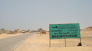
Nouadhibou is the second largest city in Mauritania and serves as a major commercial center. The city has about 118,000 inhabitants. It is situated on a 65-kilometre peninsula or headland called Ras Nouadhibou, Cap Blanc, or Cabo Blanco, of which the western side has the city of La Güera. Nouadhibou is consequently located merely a couple of kilometers from the border between Mauritania and Western Sahara. Its current mayor is Elghassem Ould Bellali, who was installed on 15 October 2018.

Zouérat is the largest town in northern Mauritania and the capital of the Tiris Zemmour region, with an approximate population of 44,649 (2013). It lies at the eastern end of the Mauritania Railway to Nouadhibou.
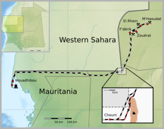
The Mauritania Railway is the national railway of Mauritania. Construction of the line began in 1960, with its opening in 1963. It consists of a single, 704-kilometre (437 mi) railway line linking the iron mining centre of Zouérat with the port of Nouadhibou, via Fderik and Choum. The state agency Société nationale industrielle et minière (SNIM) controls the railway line.
Nouakchott International Airport was an airport located in Nouakchott, the capital of Mauritania. It closed in June 2016 upon the opening of Nouakchott–Oumtounsy International Airport, 25 kilometres (16 mi) north of the city. Until late 2010, the airport served as hub of Mauritania Airways.
Dougaj is a region and town situated in the south of Western Sahara of Africa approximately midway between the Agwanit region and the Moroccan Wall, 119 km from Fderik, Mauritania. Dougaj is located in the part of Western Sahara controlled by the Polisario Front and often referred to as the Free Zone or Liberated Territories. It is the head of the 6th military region of the Sahrawi Arab Democratic Republic, and holds an SPLA military outpost.
Akjoujt Airport is an airport serving the town of Akjoujt in Mauritania. A second runway (03/21) is centerline marked, but has structures built on it.
Boutilimit Airport is an airport serving the town of Boutilimit in Mauritania.
Néma Airport is an airport serving Néma, a city in the Hodh Ech Chargui region of southeastern Mauritania.
Tichitt Airport is an airport serving the town of Tichit in Mauritania. Runway boundaries are marked in white on dark rock or dirt; are otherwise difficult to discern.
Abbaye Airport is an airport serving the town of Boghé in Mauritania.
Tazadit Airport is an airport serving the city of Zouérat in Mauritania.
Timbédra is a commune and town in the Hodh Ech Chargui Region of south-eastern Mauritania.

Mauritania Airlines, previously Mauritania Airlines International, is an airline based in Nouakchott, Mauritania, serving as flag carrier of the country. The company was set up in December 2010 in response to the demise of Mauritania Airways. In April 2018, the airline rebranded from Mauritania Airlines International to Mauritania Airlines. It is the only airline currently flying domestically within Mauritania.
Most visitors to Mauritania may obtain a visa on arrival to Mauritania, unless they are a national of one of the visa-exempt countries.

Nouakchott–Oumtounsy International Airport is an international airport serving Nouakchott, the capital of Mauritania. It is located 25 kilometres (16 mi) north of the city. The airport opened in June 2016 as the replacement for Nouakchott International Airport.
