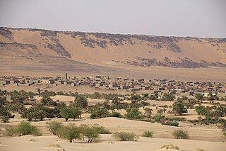
Tichit, or Tichitt, is a village at the foot of the Tagant Plateau in central southern Mauritania that is known for its vernacular architecture and proximity to the Dhar Tichitt archaeological sites. The main agriculture in Tichit is date farming, and the village is also home to a small museum.

The Adrar is a highland natural and historical region of the Sahara Desert in northern Mauritania. The Adrar Region, an administrative division of Mauritania, is named after the traditional region. It is sometimes called Adrar Tamar to distinguish it from other areas called Adrar in the Sahara.

The Tagant Plateau is located in eastern Mauritania, forming a stony part of the Sahara Desert. The Tagant Region, a national administrative division, is named after the plateau.

Aoukar or Erg Aoukar is a geological depression area of south eastern Mauritania. It is located between Kiffa and Néma, south of the Tagant Plateau. The region is also referred to as Hodh or El Hodh.
Nouakchott International Airport was an airport located in Nouakchott, the capital of Mauritania. It closed in June 2016 upon the opening of Nouakchott–Oumtounsy International Airport, 25 kilometres (16 mi) north of the city. Until late 2010, the airport served as hub of Mauritania Airways.
Akjoujt Airport is an airport serving the town of Akjoujt in Mauritania. A second runway (03/21) is centerline marked, but has structures built on it.
Boutilimit Airport is an airport serving the town of Boutilimit in Mauritania.
Fderik Airport is an airport serving the town of Fderik in Mauritania.
Kiffa Airport is an airport serving Kiffa, a city in the Assaba region of southern-est Mauritania.
Néma Airport is an airport serving Néma, a city in the Hodh Ech Chargui region of southeastern Mauritania.
Sélibaby Airport is an airport serving Sélibaby, a town in the Guidimaka region of southern Mauritania.
Tidjikja Airport is an airport serving Tidjikja, the capital of the Tagant region of central Mauritania.
Abbaye Airport is an airport serving the town of Boghé in Mauritania.
Tazadit Airport is an airport serving the city of Zouérat in Mauritania.

The ancient ksour of Ouadane, Chinguetti, Tichitt and Oualata in Mauritania were inscribed on the UNESCO World Heritage List in 1996.

The National Museum of Mauritania, also known as the National Museum of Nouakchott, is a national museum in Nouakchott, Mauritania. It is located to the southwest of the Hotel Mercure Marhaba, west of Hotel de Ville, northwest of Parc Deydouh, and northeast of the Mosque Ould Abas.

The Tichitt Culture, or Tichitt Tradition, was created by proto-Mande peoples, namely the ancestors of the Soninke people. In 4000 BCE, the start of sophisticated social structure developed among herders amid the Pastoral Period of the Sahara. Saharan pastoral culture was intricate. By 1800 BCE, Saharan pastoral culture expanded throughout the Saharan and Sahelian regions. The initial stages of sophisticated social structure among Saharan herders served as the segue for the development of sophisticated hierarchies found in African settlements, such as Dhar Tichitt. After migrating from the Central Sahara, proto-Mande peoples established their civilization in the Tichitt region of the Western Sahara. The Tichitt Tradition of eastern Mauritania dates from 2200 BCE to 200 BCE.
