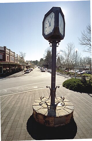
Ebor is a village on Waterfall Way on the Northern Tablelands in New South Wales, Australia. It is situated about 80 km (50 mi) east of Armidale and about a third of the way between Armidale and the coast. Dorrigo to the east is 46 kilometres (29 mi) away with the Coffs Coast 55 kilometres (34 mi) away along Waterfall Way. In the 2021 census, Ebor's zone had a population of 149.

The Oxley Wild Rivers National Park is a protected national park that is located in the Northern Tablelands region of New South Wales, Australia in the Port Macquarie-Hastings City Council and Walcha Shire councils. The 145,223-hectare (358,850-acre) park is situated 445 kilometres (277 mi) north of Sydney and is named in memory of the Australian explorer John Oxley, who passed through the area in 1818 and is one of the largest national parks in New South Wales.

The Royal National Park is a protected national park that is located in Sutherland Shire local government area in the southern portion of Sydney, New South Wales, Australia.

The Springbrook National Park is a protected national park that is located in the Gold Coast hinterland of Queensland, Australia. The 6,197-hectare (15,310-acre) park is situated on the McPherson Range, near Springbrook, approximately 100 kilometres (62 mi) south of Brisbane. The park is part of the Shield Volcano Group of the UNESCO World Heritage–listed Gondwana Rainforests of Australia.

Tamborine National Park is a protected area split between the City of Gold Coast and the Scenic Rim Region in South East Queensland, Australia, 67.5 km (41.9 mi) by road south of Brisbane.

Victoria Falls is a waterfall on the Zambezi River, located on the border between Zambia and Zimbabwe. It is one of the world's largest waterfalls, with a width of 1,708 m (5,604 ft). The region around it is inhabited by several species of plants and animals.
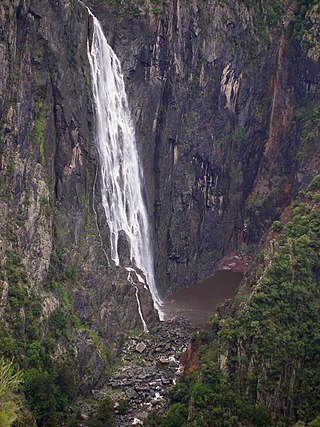
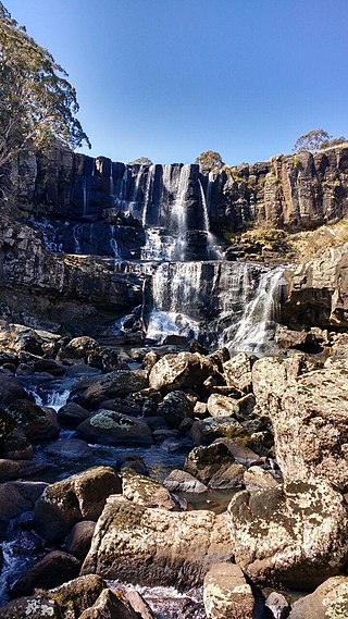
The Wollomombi Falls is a plunge waterfall on the Wollomombi River in the New England region of New South Wales, Australia.

Lawson is a town in the Blue Mountains area of New South Wales, Australia. It is located on the Great Western Highway between Hazelbrook in the east and Bullaburra in the west. Lawson has a station on the Main Western line. The town is also served by a public swimming pool and over the years has developed into the commercial hub of the mid-mountains area, which spans from Linden to Bullaburra, boasting a significant industrialized area as well as a shopping centre located on the south-eastern side of the highway.

Waterfall Way is a 170-kilometre (110 mi) country road in the Northern Tablelands region of New South Wales, Australia, linking Raleigh on the state's North Coast to Armidale. The route passes through some of New South Wales' most scenic countryside and has become well known as its best and Australia's third most beautiful tourist drive. Seven national parks, of which three are listed as World Heritage Areas by UNESCO and form part of the Gondwana Rainforests of Australia, are located on or close to the route. Dorrigo National Park encompasses the waterfalls that give the route its name.
Wentworth Falls is a town in the Blue Mountains region of New South Wales, situated approximately 100 kilometres (62 mi) west of the Sydney central business district, and about 8 kilometres (5.0 mi) east of Katoomba, Australia on the Great Western Highway, with a Wentworth Falls railway station on the Main Western line. The town is at an elevation of 867 metres (2,844 ft) AHD. At the 2016 census, Wentworth Falls had a population of 6,076.

Wentworth Falls is a three-tiered waterfall fed by the Jamison Creek, near the town of Wentworth Falls in the Blue Mountains region of New South Wales, Australia. The falls are accessible via the National Pass Walking Trail and the Overcliff/Undercliff Walk. The total height of the waterfall is 187 metres (614 ft).

Havasu Creek is a stream in the U.S. state of Arizona. It is a tributary to the Colorado River, which it joins in the Grand Canyon. It primarily runs through the Havasupai Indian Reservation. It is sometimes called Cataract Creek, and should not be confused with Cataract Canyon, Utah.

The Minyon Falls is a plunge waterfall on Repentance Creek in the Northern Rivers region of New South Wales, Australia. The waterfall descends more than 100 metres (330 ft) over the huge rhyolite cliffs which were once part of the Tweed Volcano. The water flow eroded the rocks to create the waterfall.
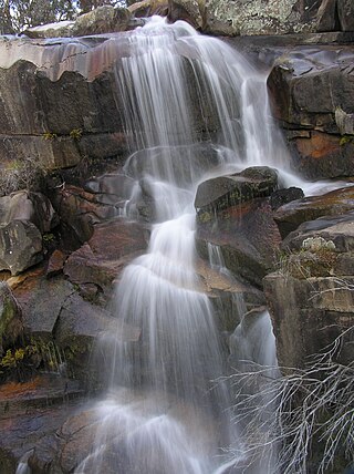
The Gibraltar Falls are a cascade waterfall on the Gibraltar Creek, in the Australian Capital Territory (ACT), approximately 50 kilometres from Canberra's city centre, The falls have a 50-metre (160-foot) drop.

The Beauchamp Falls is a cascade waterfall on the Greaves Creek where it spills into the Grose Valley, located east of the Evans Lookout, approximately 2.5 kilometres (1.6 mi) east of Blackheath in the Blue Mountains region of New South Wales, Australia.

The Bridal Veil Falls is a cascade waterfall on the Leura Falls Creek where it spills into the Jamison Valley, located south-east of Leura in the Blue Mountains region of New South Wales, Australia.

Adelina Falls is a minor waterfall located in Lawson, NSW in the South Lawson Council Reserve. Adelina Falls is located within the South Lawson Waterfall Circuit in the Blue Mountains. The falls can be accessed from the Blue Mountains Rail Line or by car.

Cataract Falls is a multilevel waterfall located near the town of Lawson in New South Wales, Australia. It is part of the South Lawson Waterfall Circuit.

The South Lawson Waterfall Circuit, officially the South Lawson Circular Waterfall Track or colloquially the Five Waterfall Walk, is a walk in Lawson, New South Wales, Australia. It is a 2.6 kilometres (1.6 mi) track that bypasses five waterfalls and an optional sixth one, off track. The landscape and biome changes a lot in the walk, ranging from wet, temperate forest, to dry forest with blue gums and wildflowers around the track. The track follows the banks of Lawson and Cataract Creek, and crosses Ridge Creek once. The track is rated as easy to medium. It has an elevation gain of 117 metres (384 ft) along the track.

Junction Falls is the name for two staircase waterfalls located within the South Lawson Waterfall Circuit, in Lawson, New South Wales. They are the second and third falls in the circuit, and is accessed from a 0.9 kilometres (0.56 mi) trail from the Northern Trailhead/Carpark of the circuit. The two falls are named Junction due to them being at the junction of Ridge Creek and Lawson Creek.


