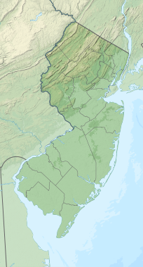
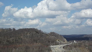
Route 23 is a state highway in the northern part of New Jersey, United States. The route runs 52.6 miles (84.7 km) from Bloomfield Avenue (CR 506 and Prospect Avenue in Verona, Essex County, northwest to the border with New York at Montague Township in Sussex County, where the road continues to Port Jervis, New York, as CR 15. Route 23 heads through Essex and Passaic counties as a two- to four-lane surface road and becomes a six-lane freeway north of a complex interchange with US 46 and I-80 in Wayne. The freeway carries Route 23 north to a concurrency with US 202. Past the freeway portion, the route heads northwest along the border of Morris and Passaic counties as a four- to six-lane arterial road with a wide median at places, winding through mountainous areas and crossing the interchange with I-287 in Riverdale. The route continues northwest through Sussex County as a mostly two-lane surface road that passes through farmland and woodland as well as the communities of Franklin, Hamburg, and Sussex before reaching the New York state line, just south of an interchange with I-84 and US 6 in Port Jervis, in Montague Township near High Point State Park.
Scouting in New Jersey has a long history, from the 1910s to the present day, serving thousands of youth in programs that suit the environment in which they live. The second Boy Scouts of America National Headquarters was in North Brunswick, although it was referred to in BSA publications as being in neighboring New Brunswick.

Bloomingdale is a borough in Passaic County, in the U.S. state of New Jersey. As of the 2020 United States census, the borough's population was 7,777, an increase of 121 (+1.6%) from the 2010 census count of 7,656, which in turn reflected an increase of 46 (+0.6%) from the 7,610 counted in the 2000 census.
Pompton Lakes is a borough in Passaic County, in the U.S. state of New Jersey. As of the 2020 United States census, the borough's population was 11,127, an increase of 30 (+0.3%) from the 2010 census count of 11,097, which in turn reflected an increase of 457 (+4.3%) from the 10,640 counted in the 2000 census.

Ringwood is a borough in Passaic County, in the U.S. state of New Jersey. As of the 2020 United States census, the borough's population was 11,735, a decrease of 493 (−4.0%) from the 2010 census count of 12,228, which in turn reflected a decrease of 168 (−1.4%) from the 12,396 counted in the 2000 census.

The Passaic River is a river, approximately 80 miles (130 km) long, in Northern New Jersey. The river in its upper course flows in a highly circuitous route, meandering through the swamp lowlands between the ridge hills of rural and suburban northern New Jersey, called the Great Swamp, draining much of the northern portion of the state through its tributaries.
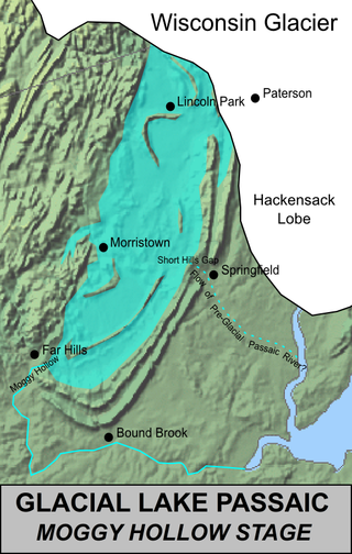
Lake Passaic was a prehistoric proglacial lake that existed in northern New Jersey in the United States at the end of the last ice age approximately 19,000–14,000 years ago. The lake was formed of waters released by the retreating Wisconsin Glacier, which had pushed large quantities of earth and rock ahead of its advance, blocking the previous natural drainage of the ancestral Passaic River through a gap in the central Watchung Mountains. The lake persisted for several thousand years as melting ice and eroding moraine dams slowly drained the former lake basin. The effect of the lake's creation permanently altered the course of the Passaic River, forcing it to take a circuitous route through the northern Watchung Mountains before spilling out into the lower piedmont.

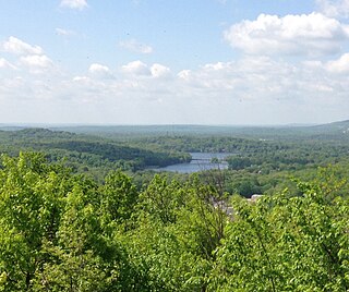
The Watchung Mountains are a group of three long low ridges of volcanic origin, between 400 and 500 feet high, lying parallel to each other in northern New Jersey in the United States. The name is derived from the American Native Lenape name for them, Wach Unks. In the 18th century, the Euro-American settlers also called them the Blue Mountains or Blue Hills. The Watchung Mountains are known for their numerous scenic vistas overlooking the skylines of New York City and Newark, New Jersey, as well as their isolated ecosystems containing rare plants, endangered wildlife, rich minerals, and globally imperiled trap rock glade communities. The ridges traditionally contained the westward spread of urbanization, forming a significant geologic barrier beyond the piedmont west of the Hudson River; the town of Newark, for example, once included lands from the Hudson to the base of the mountains. Later treaties moved the boundary to the top of the mountain, to include the springs.

The Pompton River is a tributary of the Passaic River, approximately 8 miles (13 km) long, in Passaic County in northern New Jersey in the United States.
The Pequannock River is a tributary of the Pompton River, approximately 20 miles (32 km) long, located in northern New Jersey in the United States.
The Ramapo River is a tributary of the Pompton River, approximately 30 mi (48 km) long, in southern New York and northern New Jersey in the United States.
The Newark-Pompton Turnpike, is a roadway in northern New Jersey that was originally a tolled turnpike. The roadway was first laid out in the mid-18th century and given its name in 1806. As originally designed, it connected Newark with the area north and west of the Pompton River in what is now Riverdale. Its south end is Broadway in Newark; its north end is the Paterson-Hamburg Turnpike. As such, it was part of an alternate route between Newark and Paterson.

Hudson Highlands State Park is a non-contiguous state park in the U.S. state of New York, located on the east side of the Hudson River. The park runs from Peekskill in Westchester County, through Putnam County, to Beacon in Dutchess County, in the eastern section of the Hudson Highlands.

New Jersey is a state within the United States of America that lies on the north eastern edge of the North American continent. It shares a land border with the state of New York along the north, ratified by both states after the New York – New Jersey Line War, which is its only straight line border.

The Northern New Jersey Council was formed in January 1999 and serves Bergen, Essex, Hudson and Passaic counties as an effort to better serve the Scouting communities encompassed in these areas.

Goffle Hill, also referred to as Goffle Mountain and historically known as Totoway Mountain and Wagaraw Mountain, is a range of the trap rock Watchung Mountains on the western edge of the Newark Basin in northern New Jersey. The hill straddles part of the border of Bergen County and Passaic County, underlying a mostly suburban setting. While hosting patches of woodlands, perched wetlands, and traprock glades, the hill is largely unprotected from development. Extensive quarrying for trap rock has obliterated large tracts of the hill in North Haledon, and Prospect Park. Conservation efforts seeking to preserve undeveloped land, such as the local Save the Woods initiative (2007–present), are ongoing.
The Watchung Outliers include six areas of isolated low hills and rock outcrops of volcanic and sedimentary origin in the U.S. states of New York, New Jersey, and Pennsylvania. These geologic outliers are primarily diminutive and detached remnants of the Triassic/Jurassic age Watchung Mountain basalt flows with intervening layers of sedimentary rock. All six of the outliers are found along the western edge of the Newark Basin, occupying small synclines adjacent to the Ramapo fault system. The outliers, from north to south, are known as: Ladentown, Union Hill, New Germantown/Oldwick, Prospect Hill, Sand Brook, and Jacksonwald.
The Pompton Mutiny, also referred to as the Federal Hill Rebellion, was a revolt of Continental Army troops at Pompton Camp in what was then Pompton Township, New Jersey, present-day Bloomingdale, New Jersey, that occurred on January 20, 1781, beneath the command of Colonel Israel Shreve.

The New York – New Jersey Highlands is a geological formation composed primarily of Precambrian igneous and metamorphic rock running from the Delaware River near Musconetcong Mountain, northeast through the Skylands Region of New Jersey along the Bearfort Ridge and the Ramapo Mountains, Sterling Forest, Harriman and Bear Mountain State Parks in New York, to the Hudson River at Storm King Mountain. The northern region is also known as the Hudson Highlands and the southern as the New Jersey Highlands. A broader definition would extend the region west to Reading, Pennsylvania, and east to the Housatonic River in Connecticut, encompassing the Reading Prong. The highlands are a subrange of the Appalachian Mountains.

Wanaque Reservoir is a man-made lake located within Wanaque and Ringwood, New Jersey along the Wanaque River. The reservoir came into being in 1928 by the construction of the Raymond Dam along the river in Wanaque. Besides the Wanaque River, the reservoir receives water from two diversions: the Pompton Lakes intake, which takes water from the Ramapo River, and the Two Bridges intake, which takes water from the Pompton River. It is the second largest reservoir in New Jersey by volume, after Round Valley Reservoir. It is the second largest body of water in New Jersey by area, after Lake Hopatcong.