Fernando Pedroza | |
---|---|
Municipality | |
Country | |
Region | Nordeste |
State | Rio Grande do Norte |
Mesoregion | Central Potiguar |
Time zone | UTC -3 |
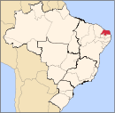
Fernando Pedroza is a municipality in the Brazilian state of Rio Grande do Norte. [1]
The municipalities of Brazil are administrative divisions of the Brazilian states. At present, Brazil has 5,570 municipalities, making the average municipality population 34,361. The average state in Brazil has 214 municipalities. Roraima is the least subdivided state, with 15 municipalities, while Minas Gerais is the most subdivided state, with 853.
Brazil, officially the Federative Republic of Brazil, is the largest country in both South America and Latin America. At 8.5 million square kilometers and with over 208 million people, Brazil is the world's fifth-largest country by area and the fifth most populous. Its capital is Brasília, and its most populated city is São Paulo. The federation is composed of the union of the 26 states, the Federal District, and the 5,570 municipalities. It is the largest country to have Portuguese as an official language and the only one in the Americas; it is also one of the most multicultural and ethnically diverse nations, due to over a century of mass immigration from around the world.
The Federative Republic of Brazil is a union of 27 federated units : 26 states and one federal district. The states are generally based on historical, conventional borders which have developed over time. The Federal District cannot be divided into municipalities, according to the Brazilian Constitution, the Federal District assumes the same constitutional and legal powers, attributions and obligations of the states and municipalities, instead, it is divided by administrative regions.
Taipu is a municipality (município) in the Brazilian state of Rio Grande do Norte. In the 2000 IBGE census, it reported a population of 11,864 inhabitants. The municipality covers a total area of 353 km².
Alecrim is a municipality in the state of Rio Grande do Sul, Brazil.
Jandaíra is a municipality in the state of Rio Grande do Norte in the Northeast region of Brazil.
São Tomé is a municipality in the state of Rio Grande do Norte in the Northeast region of Brazil.
São Bento do Norte is a municipality in the state of Rio Grande do Norte in the Northeast region of Brazil.
Galinhos is a municipality in the state of Rio Grande do Norte in the Northeast region of Brazil.
Guamaré is a municipality in the state of Rio Grande do Norte in the Northeast region of Brazil.
Macau is a municipality in the state of Rio Grande do Norte in the Northeast region of Brazil.
Florânia is a municipality in the state of Rio Grande do Norte in the Northeast region of Brazil.
Santana do Matos is a municipality in the state of Rio Grande do Norte in the Northeast region of Brazil.
Pureza is a municipality in the state of Rio Grande do Norte in the Northeast region of Brazil. The place means "pure" in Portuguese hence its pure lake located in the area, and it is depicted in the municipal seal.
Alto do Rodrigues is a municipality in the state of Rio Grande do Norte in the Northeast region of Brazil.
Itajá is a municipality in the state of Rio Grande do Norte in the Northeast region of Brazil.
Pendências is a municipality in the state of Rio Grande do Norte in the Northeast region of Brazil.
Porto do Mangue is a municipality in the state of Rio Grande do Norte in the Northeast region of Brazil.
São Rafael is a municipality in the state of Rio Grande do Norte in the Northeast region of Brazil.
Angicos is a microregion in the Brazilian state of Rio Grande do Norte.
Patu is a municipality in the state of Rio Grande do Norte in the Northeast region of Brazil.
Serra Caiada is a municipality in the state of Rio Grande do Norte in the Northeast region of Brazil.
Vila Maria is a municipality in the state of Rio Grande do Sul in the Southern Region of Brazil.
Coordinates: 5°45′40″S36°23′31″W / 5.76111°S 36.39194°W
A geographic coordinate system is a coordinate system that enables every location on Earth to be specified by a set of numbers, letters or symbols. The coordinates are often chosen such that one of the numbers represents a vertical position and two or three of the numbers represent a horizontal position; alternatively, a geographic position may be expressed in a combined three-dimensional Cartesian vector. A common choice of coordinates is latitude, longitude and elevation. To specify a location on a plane requires a map projection.
This Rio Grande do Norte, Brazil location article is a stub. You can help Wikipedia by expanding it. |