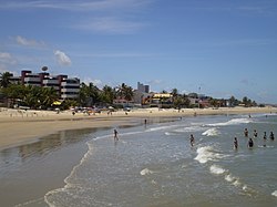
Natal is the capital and largest city of the state of Rio Grande do Norte, located in northeastern Brazil. According to IBGE's 2021 estimate, the city had a total population of 896,708, making it the 19th largest city in the country. Natal is a major tourist destination and an exporting hub of crustaceans, carnauba wax and fruits, mostly melon, sugar apple, cashew and papaya. It is the country's closest city to Africa and Europe, with its Greater Natal International Airport connecting Natal with many Brazilian cities and also operating some international flights. The city was one of the host cities of the 2014 FIFA World Cup.
Tando Jam is a town and a municipal committee of Hyderabad District in the Sindh province of Pakistan. It lies on the east of Hyderabad Taluka, about 12 kilometres northeast of the city center. As of 2017, Its population is 71,760.

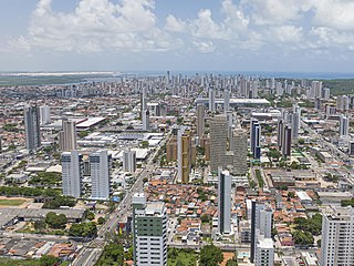
Betim is a town in Minas Gerais, Brazil. The city belongs to the mesoregion Metropolitan of Belo Horizonte (BH) and to the microregion of Belo Horizonte. It is the fifth largest city in Minas Gerais and one of the 50 largest cities in the Southeast of Brazil.
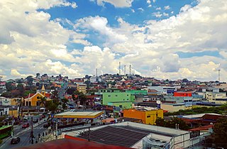
Ribeirão das Neves is a Brazilian municipality located in the state of Minas Gerais. The city belongs to the mesoregion Metropolitana de Belo Horizonte and to the microregion of Belo Horizonte. Most residents commute to Belo Horizonte. The population in 2020 was 338,197.
Adavad, also spelled Adawad or Adwad, is a village in the Chopda Tehsil of Jalgaon District, Maharashtra, India. It is situated at the southern base of the Satpura Hills, about 30 kilometres northwest of the district seat Jalgaon, and 13 kilometres east of the subdistrict seat Chopda. As of the year 2011, it has a total population of 24,357.

Wandoor is a town in Nilambur Taluk, Malappuram District, Kerala, India. It is located on the southeast of Chaliyar River, about 24 kilometres northeast of the district seat Malappuram, and 8 km south of the taluk seat Nilambur. In the year 2011, the town has a population of 50,973.

Hafizabad is a city and capital of Hafizabad District located in Punjab, Pakistan. It is located to the east of Chenab River. As of 2017, its total population is 245,751.

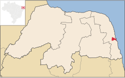
Güicán de la Sierra, also known as Nuestra Señora de la Candelaria de Güicán, is a town and municipality in the Colombian Department of Boyacá. It is close to the national natural park El Cocuy National Park. As of the year 2020, it has a total population of 6,426.

The climate of Los Angeles is mild to hot year-round, and mostly dry. It is classified as a Mediterranean climate, which is a type of dry subtropical climate. It is characterized by seasonal changes in rainfall—with a dry summer and a winter rainy season. Under the modified Köppen climate classification, the coastal areas are classified as Csb, and the inland areas as Csa.
Chinchali is a village in Raybag Taluk, Belagavi District, Karnataka, India. It is located near the state boundary with Maharashtra, approximately 84 kilometres north of the district seat Belgaum, and 10 kilometres northeast of the taluk seat Raibag. In the year 2011, the village has a population of 18,986.
Oju is a local government area in Benue State, Nigeria. It borders Obi and Gwer East in the north, Konshisha and Yala in the east, Izzi and Ebonyi in the south, and Ado in the west. As of 2022, its total population is 243,300.
Parham is a village in Jasrana Tehsil, Firozabad District, Uttar Pradesh, India. As of the year 2011, it has a population of 19,642.
Tirthpuri is a village in Ghansawangi Taluka, Jalna district, Maharashtra, India. According to the 2011 Census of India, it is home to 10,148 residents.
Chahardi is a village in Chopda Taluka, Jalgaon District, Maharashtra, India. It is located at the north of Tapti River, approximately 44 kilometres northwest of the district seat Jalgaon, and 8 kilometres southwest of the subdistrict seat Chopda. As of the year 2010, it has a total population of 11,115.
Dhamdaha is a village and the administrative division of Dhamdaha Block, Purnia District, Bihar, India. It is situated in the Eastern part of Bihar, about 26 kilometres southwest of the block capital Purnia. In the year 2011, the village has a total population of 37,987.
Itawa is a town in Pipalda Tehsil, Kota District, Rajasthan, India. It is located near the state boundary with Madhya Pradesh, about 79 kilometres northeast of the district seat Kota, and 5 kilometres southwest of the tehsil seat Pipalda. As of 2011, the town has a population of 26,741.
Jale, or Jalley, is a town and the administrative center of Jale Block, Darbhanga District, Bihar, India. It is located to the north of Bagmati River, about 32 kilometres northwest of the district capital Darbhanga. The town was named after Jaleshwari sthan which is a pilgrimage site in rural area of Darbhanga. In the year 2011, it has a total population of 37,256.
Ciomas is a kecamatan in Bogor Regency, West Java, Indonesia. It is located near the provincial border with Banten, about 21 kilometers southwest of the regency capital Cibinong, and 3 kilometers west of the city center of Bogor. It borders Bogor Barat in the north, Bogor Selatan in the east, Tamansari in the south, and Dramaga in the west. In 2021, Ciomas has a total population of 172,336.
Narmada is a kecamatan in West Lombok Regency, West Nusa Tenggara, Indonesia. It is located on the west side of the island Lombok, approximately 10 kilometers east of Mataram. In 2022, its population was 104,100.

Tanah Grogot is a kecamatan and the capital of Paser Regency, East Kalimantan, Indonesia. It shares a border with Kuaro in the north, Pasir Belengkong in the south. In the year 2020, its total population is 76,344.