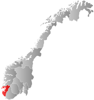
Rogaland is a county in Western Norway, bordering the North Sea to the west and the counties of Vestland to the north, Telemark to the east and Agder to the east and southeast. As of 1 January 2024, it had a population of 499,417 people.

Sandnes is a city and municipality in Rogaland, Norway. It lies immediately south of Stavanger, the 4th largest city in Norway, and together the Stavanger/Sandnes area is the third-largest urban area in Norway. The urban city of Sandnes lies in the extreme western part of the vast municipality and it makes up about 5% of the total land area of the municipality.
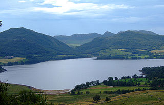
Gjesdal is a municipality in Rogaland county, Norway. It is located in the traditional district of Jæren. The administrative centre of the municipality is the village of Ålgård. Other villages in Gjesdal include Dirdal, Frafjord, Gilja, Gjesdal, and Oltedal. The municipality lies about 25 kilometres (16 mi) to the southwest of the city of Stavanger in southwestern Norway.

The Jæren Line was a 74.7-kilometer (46.4 mi) long railway line between Stavanger and Egersund in Jæren, Norway. The name is no longer in official use and the section is regarded as the westernmost part of the Sørlandet Line. Owned by Bane NOR, the line has double track from Stavanger Station to Sandnes Station, and single track from Sandnes to Egersund Station. The line is electrified at 15 kV 16.7 Hz AC and equipped with centralized traffic control and GSM-R. The line is served by the Jæren Commuter Rail and intercity trains along the Sørlandet Line, both operated by Go-Ahead Norge. CargoNet runs container freight trains on the line, which terminate at Ganddal Freight Terminal.

Kristiansand Region is a statistical metropolitan region in Agder county in southern Norway. It is centered on the city of Kristiansand. The region consist of six municipalities in the centre of Southern Norway. Vennesla, Iveland, and Birkenes are inland municipalities while Kristiansand, Lindesnes, and Lillesand are coastal municipalities. Kristiansand is the largest municipality in population in the region.

Ålgård is the administrative centre of Gjesdal municipality in Rogaland county, Norway. The village is located along the European route E39 highway, about 10 kilometres (6.2 mi) southeast of the city of Sandnes in the Jæren district of the county. The village includes the neighborhoods of Ålgård, Bærland, Fiskebekk, Opstad and Solås. The large lake Edlandsvatnet lies on the south side of the village, emptying into the river Figgjoelva which runs northwest to Sandnes.
The larger Kvernaland area is an amalgamation of villages in Rogaland county, Norway. The village is located along the north end of the lake Frøylandsvatnet. The village is located in both the municipalities of Klepp and Time. The eastern part of the village is also known as Orstad and the western part of the village is known as Frøyland or simply as Kvernaland. The village of Klepp stasjon lies just southwest of the village on the west side of the lake and the small village of Foss Eikjeland lies just north of the village, along the river Figgjo.
Vatne is a village in Sandnes municipality in Rogaland county, Norway. The village lies in the borough of Hana, just about 3 kilometres (1.9 mi) northeast of the centre of the city of Sandnes. The Vatneleiren military base is located in Vatne.

Ålgård Fotballklubb is a men's football club located in Ålgård, Norway that was founded in 1915. Ålgård played in Hovedserien, then the highest division in Norway, for several years after World War II. The club has been playing mainly at the third tier level, and was last promoted to 2. divisjon in 2002.

Høle is a previous borough and a village in the eastern part of Sandnes municipality in Rogaland county, Norway, located along the Høgsfjorden. The area was historically a part of the municipality of Høle. Høle Church and Høle School are both located in the village.

Hommersåk is a village in Sandnes municipality in Rogaland county, Norway. The village is located in the borough of Riska in the northern part of the municipality. It is situated about 12 kilometres (7.5 mi) northeast of the centre of the city of Sandnes, along the shore of the Riskafjorden, an arm off the main Gandsfjorden. The 2.28-square-kilometre (560-acre) village has a population (2019) of 6,425 and a population density of 2,818 inhabitants per square kilometre (7,300/sq mi).
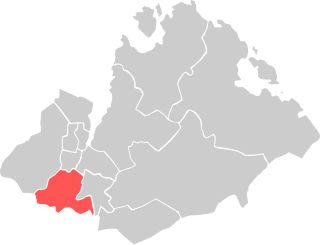
Ganddal is a borough of the city of Sandnes in the west part of the large municipality of Sandnes in Rogaland county, Norway. The 12.1-square-kilometre (4.7 sq mi) borough is located in the southwest part of the municipality. Ganddal has a population (2016) of 7,318.

Figgjoelva or Figgjo is a river in Rogaland county, Norway. The 26.4-kilometre (16.4 mi) long river begins at the lake Edlandsvatnet in the village of Ålgård in Gjesdal municipality. It then heads north into the municipality of Sandnes before heading west. For a while, the river forms the municipal border between Sandnes and Time and between Sandnes and Klepp. The last part of the river runs west through Klepp before emptying into the North Sea. The Feistein Lighthouse lies on a small island, just northwest of the mouth of the river. The main part of the river is 26.4 kilometres (16.4 mi), but if you include the tributaries, the river is about twice as long at 45 kilometres (28 mi).

Stavanger/Sandnes is the Third largest urban area in Norway. It consists of the densely built-up areas in the municipalities of Stavanger, Sandnes, Sola, and Randaberg, most of which are located on the Stavanger Peninsula, its surrounding islands, and the mainland south of the peninsula. Stavanger/Sandnes is the central part of the Stavanger Region.

The Ålgård Line is a closed, but not abandoned, railway line between Ganddal and Ålgård in Rogaland, Norway. The 12.24-kilometer (7.61 mi) line was built as a narrow gauge branch line of the Jæren Line by the Norwegian State Railways (NSB) and opened in 1924. It runs through the villages of Foss-Eikeland and Figgjo in Sandnes to Ålgård in Gjesdal. Several proposals were made for the Ålgård Line to become the first part of the main line from Stavanger to Oslo, but instead the Sørlandet Line was connected to the Jæren Line in 1944. At the same time, the Ålgård Line was upgraded to standard gauge.

Ganddal Station is a railway station in the western part of the municipality of Sandnes in Rogaland county, Norway. The station is located just south of the centre of the city of Sandnes in the Ganddal borough. It sits along the Sørlandet Line with long-distance service to Stavanger to the north and Kristiansand to the southeast. The station is also served by the Jæren Commuter Rail with local service between Stavanger and Egersund. The station is 18.49 kilometers (11.49 mi) south of Stavanger. The station is simply a shelter and it has no bathrooms, food services, or ticket counters.
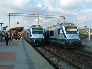
The Jæren Commuter Rail is a commuter train service operated along the westernmost part of the Sørland Line in Jæren, Norway. It is operated by Go-Ahead Norge with nine Class 72 electric multiple units. The service acts as a commuter rail connecting Stavanger to its suburbs, including Sandnes, and to towns further south, in Klepp, Time, Hå and Eigersund. Although passenger services have operated along the lines since 1878, the commuter train service was inaugurated in 1992 with a significant increase of service, using existing rolling stock. Ridership of the system increased from 3.2 million in 2012 to 5 million in 2019.

Solakrossen or Sola is the administrative center of Sola municipality in Rogaland county, Norway. The village is located at the south end of the Hafrsfjorden on the Stavanger Peninsula, just northwest of the city of Sandnes. The large Stavanger Airport, Sola is located on the west side of the village. The village of Sørnes lies just to the north. Sola Church lies on the far western edge of Solakrossen. The population of Solakrossen is about 10,000, but the population is not separately tracked since it is part of the Stavanger/Sandnes urban area. The newspaper Solabladet has been published in Solakrossen since 1991. It is published in a paper edition on Thursdays and online every day.
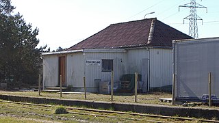
Foss-Eikeland or Foss Eikjeland is a village in the western part of the large Sandnes municipality in Rogaland county, Norway. The village lies just south of the city of Sandnes, just north of the river Figgjoelva and the municipal border. The neighboring village of Orstad lies to the south, across the river. The Ålgård Line previously had a station at Foss-Eikeland, but the railway line is currently closed, but not abandoned.

Malmheim og Soma is a borough of the city of Sandnes in the west part of the large municipality of Sandnes in Rogaland county, Norway. The 20-square-kilometre (7.7 sq mi) borough sits in the western part of the municipality and it has a population of 1,597. It was created in 2011 when the old boroughs of Malmheim and Soma were merged. The Julabygda Chapel is located in the small village of Julebygda in this borough.


