Stadio Porta Elisa is a multi-use stadium in Lucca, Italy. The authorized capacity is 7,386, but it can hold about 12,000; 2,500 of them are covered.

Nartopa or Nartupa is a village in Hazro Tehsil, Attock District in Punjab province, Pakistan.
Gozdawa is a village in the administrative district of Gmina Mogilno, within Mogilno County, Kuyavian-Pomeranian Voivodeship, in north-central Poland.

Wiertelaki is a village in the administrative district of Gmina Brąszewice, within Sieradz County, Łódź Voivodeship, in central Poland. It lies approximately 4 kilometres (2 mi) north-west of Brąszewice, 26 km (16 mi) west of Sieradz, and 79 km (49 mi) west of the regional capital Łódź.
Budy Trzcińskie is a village in the administrative district of Gmina Nowy Kawęczyn, within Skierniewice County, Łódź Voivodeship, in central Poland.

Czarna is a village in the administrative district of Gmina Stąporków, within Końskie County, Świętokrzyskie Voivodeship, in south-central Poland. It lies approximately 3 kilometres (2 mi) south-west of Stąporków, 10 km (6 mi) south-east of Końskie, and 30 km (19 mi) north of the regional capital Kielce.

Yablanitsa Glacier is a 1.8 km long glacier on Smith Island in the South Shetland Islands, Antarctica. It is situated north-northeast of Chuprene Glacier, southwest of Vetrino Glacier and northwest of Ovech Glacier, and flows west of Drinov Peak into Cabut Cove. The feature is named after the town of Yablanitsa in northern Bulgaria.
Ołdaki is a village in the administrative district of Gmina Gzy, within Pułtusk County, Masovian Voivodeship, in east-central Poland.
Piekło is a village in the administrative district of Gmina Domaszowice, within Namysłów County, Opole Voivodeship, in south-western Poland.

Nowa Parszczenica is a village in the administrative district of Gmina Konarzyny, within Chojnice County, Pomeranian Voivodeship, in northern Poland. It lies approximately 11 kilometres (7 mi) north of Konarzyny, 26 km (16 mi) north of Chojnice, and 94 km (58 mi) south-west of the regional capital Gdańsk.

Ponent, Lleida or Terres de Lleida is one of the seven territories defined by the Regional Plan of Catalonia. It is not clear what name will have, being all of them traditionally accepted names for the region.
Burlingame Reservoir is a body of water in Glocester, Providence County, Rhode Island, United States, and is part of the Durfee Hill Management Area.

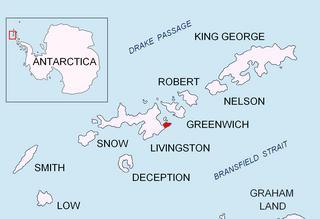
Ihtiman Hook is a gravel barrier spit extending 700 m westward from the north coast of Burgas Peninsula on Livingston Island in the South Shetland Islands, Antarctica. Situated 2.8 km east-northeast of Rila Point, 5.9 km west of Renier Point, and 1.5 km south of Half Moon Island.

Vidova is a village in the municipality of Čačak, Serbia. According to the 2011 census, the village has a population of 121 people.
The Tennis Courts are courts located in Berlin, Germany. Located southwest of the Olympic Stadium, they hosted the basketball and the Épée fencing event for the 1936 Summer Olympics.
Uniküla is a village in Kastre Parish, Tartu County in eastern Estonia.
Katun is a village in the municipality of Vranje, Serbia. According to the 2002 census, the village has a population of 432 people.
KYOX, "the Ox", is a radio station airing a country music format licensed to Comanche, Texas, broadcasting on 94.3 MHz FM. The station is owned by Robert Elliott, Jr., through licensee Villecom LLC,

Arda is an unincorporated community in Washington Township, Pike County, in the U.S. state of Indiana.

Fountain Park is an unincorporated community in Otsego Township, Steuben County, in the U.S. state of Indiana.


