
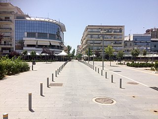
Haskovo is a city in the region of Northern Thrace in southern Bulgaria and the administrative centre of the Haskovo Province, not far from the borders with Greece and Turkey. According to Operative Program Regional Development of Bulgaria, the urban area of Haskovo is the seventh largest in Bulgaria and has a population of 184,731 inhabitants. The number of inhabitants of Town of Haskovo is 67,086 people, according to the 2021 census.

Svilengrad is a town in Haskovo Province, south-central Bulgaria, situated at the border of Bulgaria, Turkey and Greece. It is the administrative centre of the homonymous Svilengrad Municipality.
Kastanies is a town located in northern part of the regional unit of Evros, Greece, and is part of the municipal unit of Vyssa. It is situated at the border with Turkey.
Orestiada, is the northeasternmost, northernmost and newest city of Greece and the second largest town of the Evros regional unit of Thrace. Founded by Greek refugees from Edirne after the Treaty of Lausanne when the population exchange occurred between Turkey and Greece, in which the river Evros became the new border between the two countries. The population is around 20,000.

Parvomay is a town, part of the municipality of the same name in southern Bulgaria. It is located in Plovdiv Province, close to the towns Sadovo and Chirpan. The word literally means First of May, i.e., May Day, in English and is sometimes transliterated as Parvomai or Purvomai.

Kalofer is a town in central Bulgaria, located on the banks of the Tundzha between the Balkan Mountains to the north and the Sredna Gora to the south. Kalofer is part of Plovdiv Province and the Karlovo municipality. It is best known as the birthplace of Bulgarian poet and revolutionary Hristo Botev.
Topolovgrad is a town in south-central Bulgaria, part of Haskovo Province, situated at the northern foot of the Sakar Mountain. It is the administrative centre of the homonymous Topolovgrad Municipality.
Orfeas, named after the mythical musician Orpheus, is a former municipality in the Evros regional unit, East Macedonia and Thrace, Greece. Since the 2011 local government reform it is part of the municipality Soufli, of which it is a municipal unit. Its land area is 643.266 km2 and its population was 4,761 inhabitants at the 2011 census. It is located in the north-central part of Evros, and borders both southeastern Bulgaria and northwestern Turkey. The seat of the municipality was in Lavara. Much of the land is mountainous and forested to the west, extending up to the Rhodope regional unit. It is linked with GR-51. The town of Lávara sits on a plain. It is located SE of Svilengrad, S of Edirne, Turkey and Orestiada, and 13 km N of Soufli and 78 km N of Alexandroupoli. The municipality's next largest towns are Agriani, Mega Dereio and Amorio.
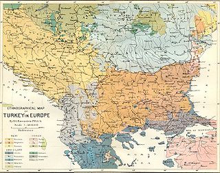
Greeks in Bulgaria constitute the eighth-largest ethnic minority in Bulgaria. They number 1,356 according to the 2011 census. They are estimated at around 25,000 by Greek organizations and around 28,500 by the Greek government. These larger estimates include the Sarakatsani community, the descendants of the post-WWII Greek emigrants, and other Greek citizens living in Bulgaria as students, businessmen, consorts etc. Today, Greeks mostly live in the large urban centres like Sofia and Plovdiv, but also in the coastal zone.
Komara is a village in the northwestern part of the Evros regional unit in northern Greece. Komara is in the municipal unit of Trigono. Its population was 628 in 2011. Komara is situated on the left (northern) bank of the river Arda, near the border with Bulgaria. It is 2 km north of Kyprinos, the nearest larger village. It is 20 km south of the Bulgarian town Svilengrad, 27 km northwest of Orestiada and 29 km west of the Turkish city Edirne.
Dikaia is a village in the northern part of the Evros regional unit in Greece. Dikaia was the seat of the former municipality of Trigono, and is part of the municipality Orestiada since 2011. In 2011, its population was 561 for the village and 834 for the community, which includes the villages Dilofos, Krios and Palli. It is located on the right bank of the river Evros, where it forms the border with Bulgaria. It is about 15 km southeast of Svilengrad, Bulgaria, and 25 km west of Edirne, Turkey.
Uzundzhovo is a village in southeastern Bulgaria, part of Haskovo municipality, Haskovo Province. As of 2008, it has a population of 1,727 and the mayor is Vancho Vanchev. The village lies in the agricultural Upper Thracian Plain, east of Haskovo, south of Dimitrovgrad and west of Simeonovgrad and Harmanli. During Ottoman rule, the village was known as Uzunca ova, a direct translation of the area's former Byzantine Greek appellation, Makri livada. The village's current name is derived from the Ottoman Turkish name and modified with the Slavic placename suffix -ovo. An architectural reminder of the village's Ottoman history can also be seen, as the local Church of the Assumption was built originally as a mosque. Uzundzhovo hosts the Bulgarian Air Force's 21st Fighter and Bomber Airbase, shut down in 1998.

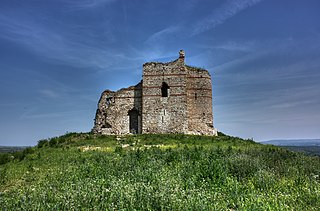
Mezek is a village in southeastern Bulgaria, part of Svilengrad municipality, Haskovo Province. It lies at the foot of the eastern Rhodope Mountains, just north of the Bulgaria–Greece border and not far west of the Bulgaria–Turkey border. Mezek is famous for the well-preserved medieval Mezek Fortress and its two ancient Thracian beehive tombs, the Mezek and Sheynovets tombs. The village is also well known for its own winery and the Mezzek brand of Bulgarian wine.
Matochina is a small village in southeastern Bulgaria, part of Svilengrad municipality, Haskovo Province. Matochina lies in the southernmost ridges of the Sakar Mountain, 40 kilometres (25 mi) from the municipal centre Svilengrad and 110 kilometres (68 mi) from the provincial capital Haskovo; it is located just west of the Bulgaria–Turkey border and not far northeast of the Bulgaria–Greece border. The village is famous for the medieval Matochina Fortress.

The French-Hellenic Railway Co. was a railway company in Greece and Turkey which operated the former Chemins de fer Orientaux railway line from Alexandroupolis to Pythio, Ormenio and Svilengrad between 1929 and 1954. The company was absorbed by the Hellenic State Railways in 1954.
Dositeevo is a village in the municipality of Harmanli, in Haskovo Province, in southern Bulgaria. During the Ottoman rule of present-day Bulgaria, the name of the village was Suluköy. The village became part of the Principality of Bulgaria in 1885.
Dobroselets is a village in the municipality of Topolovgrad, in Haskovo Province, in southern Bulgaria. It is located in the north slope of Sakar mountain at about 10 km north of Topolovgrad, 28 km west of Elhovo and 55 km southwest of Yambol. It is located at an altitude of 191 m, and has a population of 130 people.

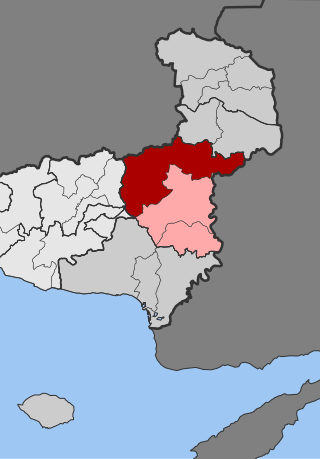
Topolovgrad Municipality is a municipality (obshtina) in Haskovo Province, Southeastern Bulgaria. It is named after its administrative centre - the town of Topolovgrad.

The Alexandroupoli–Svilengrad railway is a 178.5 kilometres (110.9 mi) long railway connecting the port of Alexandroupoli in Eastern Macedonia and Thrace, Greece with Svilengrad in Bulgaria, via the village of Ormenio. Despite its name, as of 2020 there is only passenger service on the section on Greek territory, between Alexandroupoli and Ormenio, as the international services to Sofia and Istanbul have been suspended as of 2011.
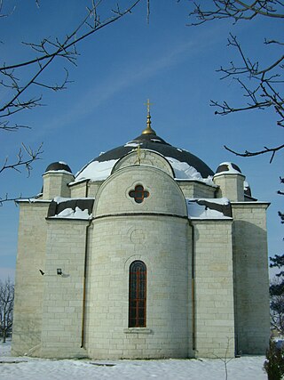
Matochina Fortress, also known as Bukelon – Roman, Byzantine and Bulgarian medieval fortress.
