
Ciruelos de Cervera is a municipality located in the province of Burgos, Castile and León, Spain.

Chuchur is a hamlet in the municipality of Smolyan, located in the Smolyan Province of southern Bulgaria. The village is located 177.9 km from Sofia. As of 2007, the village had a population of 6 people.
Dimovo is a small village in the municipality of Smolyan, located in the Smolyan Province of southern Bulgaria. The village is located 166.88 km from Sofia. As of 2007, the village had a population of 11 people.
Novo Leski is a village in Hadzhidimovo Municipality, in Blagoevgrad Province, Bulgaria.
Ivanovo, Blagoevgrad Province is a village in Petrich Municipality, in Blagoevgrad Province, Bulgaria.
Laskarevo is a village in the municipality of Sandanski, in Blagoevgrad Province, Bulgaria.
Lebnitsa is a village in the municipality of Sandanski, in Blagoevgrad Province, Bulgaria.
Lyubovishte is a village in the municipality of Sandanski, in Blagoevgrad Province, Bulgaria.

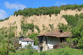
Rozhen, Bulgaria is a village in the municipality of Sandanski, in Blagoevgrad Province, Bulgaria. It is situated at the south-western foothills of the Pirin mountain range and is nestled within the Melnik Earth Pyramids. In its outskirts is located the Rozhen Monastery, the largest one in Pirin.
Ekzarh Antimovo is a village in Karnobat Municipality, in Burgas Province, in southeastern Bulgaria.
Malki Stanchovtsi is a village in Tryavna Municipality, in Gabrovo Province, in northern central Bulgaria.
Popraykovtsi is a village in Tryavna Municipality, in Gabrovo Province, in northern central Bulgaria.
Maslinovo is a village in the municipality of Haskovo, in Haskovo Province, in southern Bulgaria.
Vaglarovo is a village in the municipality of Haskovo, in Haskovo Province, in southern Bulgaria.
Yerusalimovo is a village in the municipality of Lyubimets, in Haskovo Province, in southern Bulgaria.
Glumovo is a village in the municipality of Ivaylovgrad, in Haskovo Province, in southern Bulgaria.
Karlovsko is a village in the municipality of Ivaylovgrad, in Haskovo Province, in southern Bulgaria.
Pashkul is a village in the municipality of Ivaylovgrad, in Haskovo Province, in southern Bulgaria.
Dushka is a village in Chernoochene Municipality, in Kardzhali Province, in southern-central Bulgaria.

Elmalı is a village in Uzunköprü district of Edirne Province, Turkey, It is situated in the Eastern Thrace plains at 41°10′N26°54′E. The distance to Uzunköprü is 20 kilometres (12 mi). The population of the village was 830 as of 2011. The old name of this village is Ermeniköy. It was a Bulgarian village during the Ottoman Empire era. But after the Second Balkan War the Bulgarian population was forced to leave the settlement.


