Filoti (in Greek: Φιλώτι or Φιλότι; officially: Φιλότιον) is a semi-mountainous village of central Naxos, Greece, with a population of 1,617 residents (census 2021), [1] located at the foot of Mt. Zas (1,004 m), at an altitude of 400 meters, about 18.2 kilometres (11.3 mi) from the city of Naxos. [2] [3] It is located on the slopes of two hills and consists of three settlements, Rachidi, Klefaros and Lioiri. [3] Its stand out is the Orthodox church of Panagia Filotitissa that is dedicated to the Assumption of the Virgin, a basilica built in 1718 in the place of an old Byzantine church. [4] [5] [6] The economy of the village is mainly based on livestock products, secondarily in agriculture and tourism. It has a Primary School (since 1838), a Professional High School, a Multipurpose Regional Doctor, a Citizen Service Center (KEP), a Post office, a dentist and a pharmacy.
Together with Kalandos (pop. 10), constitutes the Municipal Community of Filoti (pop. 1487), which belongs to the municipal unit of Drymalia, of the municipality of Naxos and Lesser Cyclades, of the regional unit of Naxos (of the former county of Cyclades), in the administrative region South Aegean, Greece.
The first image of the visitor approaching the village from the main motorway is impressive because it is built amphitheatrically on two hills. [3] To the left is the settlement of Klepharos and to the right of Rachidi. The latest settlement of Lioiri does not seem because have been developed on a flat site opposite the other settlements and is so called because it was once an olive grove. [Note 1] The next one you meet is the square of the village, dominated by a hundred-year-old plane-tree (since 1912). [7] The square is called Gefira (in English means "bridge", because many years ago there was a bridge and a stream with waters that ran from the fountains of Kalamos and Agia Irini. [3] Then, there was a watermill fed by a cistern, the remains of which are still preserved. [8] [9] Many years ago this area was not used as a square of the village, there were other places in the two settlements, most known were the historical square of Lachanario, located in the settlement of Klefaros and the squares of Agios Konstantinos and Fasola, located in the settlement of Rachidi. The interior of the two old settlements on the two hills is what more traditional one would expect from an old cycladic village, such as the large historic church of Panagia at Lakanario square, paved labyrinthine streets, arches and steasta (covered walkway). It has been classified since 1988 as a traditional settlement. [10] [11]
All informations are from Hellenic Statistical Authority. [12] Census of years 1835 to 1991 refers to de facto population, [Note 2] while 2001 to 2021 refers to permanent population.
Year | 1835 | 1879 | 1889 | 1896 | 1907 | 1920 | 1928 | 1940 | 1951 | 1961 | 1971 | 1981 | 1991 | 2001 | 2011 | 2021 |
---|---|---|---|---|---|---|---|---|---|---|---|---|---|---|---|---|
Population | 1130 | 1541 | 1570 | 1753 | 1796 | 2122 | 2098 | 2073 | 1947 | 1669 | 1475 | 1474 | 1576 | 1503 | 1477 | 1617 |
References | [13] | [14] | [15] | [16] | [17] | [18] | [19] | [20] | [21] | [22] | [23] | [24] | [25] | [26] | [27] | [1] |
The municipal community or apartment includes the settlements Filoti and coastal Kalandos ( 36°56′12.7″N25°28′22.8″E / 36.936861°N 25.473000°E ). The municipal community of Filoti has the largest acreage in Naxos. In population comes second after the municipal community of Naxos where the city of Naxos (Chora) belongs. The village itself is the most populous village of the island. [29]
Today, together with Kalandos (pop. 10), it constitutes the Municipal Community of Filoti (pop. 1487), which belongs to the municipal unit of Drymalia, of the municipality of Naxos and Lesser Cyclades, of the regional unit of Naxos (of the former prefecture of Cyclades), in the administrative region South Aegean.
Near the village there is the Cave of Zas ( 37°2′6.6″N25°29′53.5″E / 37.035167°N 25.498194°E )[ photo], where from the finds of excavations in the years 1985-6 and 1994 appears the cave to have a continuous human presence from the newer Neolithic period (4300-3200 BC). [39] [40] [41] In the exact location of the present village settlements (Klepharos and Rachidi) no important archaeological finds have been revealed, but scattered fragments of black-figure potteries of the classical and Hellenistic period. It is probable that there will be a prehistoric cemetery west of the settlement of Rachidi, at Matouli position and a cemetery of historical times at the beginning of Rachidi near the central square and east of the motorway. [42] The only evidence of the existence of an ancient settlement in today's place is its location for the following reasons: [43]
Apart from the cases it is known that in the Neolithic and Archaic period, the greatest activity is observed mainly in the coastal settlements (as in Grotta of Naxos town ( 37°6′30″N25°22′33″E / 37.10833°N 25.37583°E ), Apollonas ( 37°10′46″N25°32′59″E / 37.17944°N 25.54972°E ), Kastraki ( 37°00′18″N25°23′17″E / 37.00500°N 25.38806°E ), Spedos ( 36°57′18″N25°30′26″E / 36.95500°N 25.50722°E ), Panermos ( 36°57′40.6″N25°32′5″E / 36.961278°N 25.53472°E ) and Kalantos) and less in mountainous. [44]
Filoti population is rising in the 7th to 10th centuries because of the abandonment of coastal settlements, from the fear of piratical raids, especially the Saracen pirates, which are based on Crete, drowning horror on the coasts of Naxos and the other Aegean islands. [45] At the end of the early Byzantine period (500-650 AD) many churches were built in Naxos in the early Christian basilica architecture. [46] It is estimated that at this time the earlier and small church of the Virgin Mary of Filotitissa was built. [47] In the following years, the Byzantine Empire slowly diminishes, and turmoil and uncertainty prevail throughout the island.
In 1207 the Venetian Marco I Sanudo occupies Naxos and begins the oppressive Venetian feudalism. Sanudo divides the island into 56 fiefs; in the most fertile areas he instated his own people, forcing the natives to cultivate the occupations of the conquerors as serfs or to exploit barren and mountainous lands. [48] [49] Within these 56 fiefs we have a clear reference to a fief with the name "Filotis" (in Greek: «Φιλότης»). [50] Several written reports during the Frankish rule show that Filoti, with his region, was one of the most important feuds. [51] Around 1344, the Turkish pirates destroyed the neighboring settlement of Aria, but Filoti is rescued, where the survivors were moved. Prior to the destruction of Aria, Filoti numbered 200 residents and Argia 300. [52] [53]
In 1537 the Turks occupy Naxos. The Venetians, although subjected and taxed by the Turks, continue to be the landowners of the island, but under the Ottoman administration. This seems to be convenient to Turks and Venetians as well. Turks exercise the administration and collect the taxes through the Venetians, who have a good knowledge of the place for many years. Venetians were compromised to obey Turks instead of their own rulers and to treat the natives as vassals like before. Filotians, like everyone on the island, are essentially in double possession and are starting to react. The first known rebellion of Naxos villagers against the seigniors, due to excessive taxation, is reported in 1641. [4] It is a transitional period in which Turks, in order to appease the reactions of the Orthodox population, begin to restrict the privileges of Venetians and give more rights to the Naxians. Before the Turkish domination in Naxos (1537), the feudal fortunes were inherited or the Duke's consent needed to be transferred. After 1537, their fiefs and possessions were transferred as common estates. [48] In 1621 the Ottoman regime established the institution of the Common (communities) [Note 3] and Filoti belongs to the "Common of the Villages". [54] With the institution of communities, Greeks are allowed to have community administration with elders, to take collective decisions and to submit them to the Turkish administration. [55]
At this transitional period the Barozzi family takes over the fief of Filoti. In 1620, Zorzeto Barozzi bought a tower-like mansion in the center of the village, from a certain Tzuane Tagari, known since then as the "Barozzi Tower". [56] Zorzeto Barozzi, was a groom and heir of the last Venetian duke of Naxos, Giacomo IV Crispo. He was succeeded by his son Jacob Barozzi, who was one of the most oppressive seignior of Filoti and held the fief from 1648 to 1676. Because the feudal privileges had begun to be lost, Jacob Barrotzi, trying to claim and secure his feudal fortune, collected documents from 1372 to 1667 and named the collection "My hegemony in Filoti". [57] He came to occupy 71% of the land. He presented as his own property even the church of Panagia with the adjoining churches of Agia Paraskevi and Agios Ioannis, with the demand for rent for its use, as well as the right to appoint its priests. [58] [57] [59] Although under the Ottoman administration, the seignior insisted on the tactics of the Venetian era and presented Filoti as his property. [60]
In 1669, Filoti accepts refugees from Crete when it was captured by the Turks. [4]
Under these conditions, long-standing conflicts began between feudal and inhabitants, culminating in the 1680–1690 decade. Filotians demand in the place of the old Byzantine church of Panagia to build a new bigger one and ask for a part of the garden of the "Lachanario" – today's homonymous square in Klefaro – which belonged to the feudal lord. During this controversy, from 1676 to 1714, the son of Iakovos, Chrysanthos Barozzi, continued to be the same intransigent. The situation changed when Ιeronimo succeeded Chrysanthos (1717–1721), who was reconciled with the Filotians. [61] In 1717 he granted not only part of the "Lachanario" to build the new church, but the whole to exist a square next to the church. [Note 4] [62] The reconciliation seems to have been a one-way solution for feudal Ιeronimo Barozzi, because the Frankish rule had come to its end. In 1721 the privileges of the feudal lords were abolished and they were considered to be equal to the Naxians. [63] In addition, since 1566 when the Ottoman rule had consolidated, Filotians were no longer villeins and because of Turkish occupation they could migrate for work anywhere in Turkey (as in Smyrna, Vourla and Constantinople). [64] This created a shortage of workers and forced the feudal lords to grant greater benefits to have their estates cultivated, reaching the point of selling or giving up part of them. It is characteristic that in 1567 and 1621 with the requirement of the landowners had banned the massive migration. [63] In addition, around 1690, the locals began to bring money from abroad and acquire their own properties, which reached up to Kalandos, Marathos, Archatos and Kampos. [65]
In 1718 the new church was founded, [62] which was completed in 1806 and its inauguration took place on 15 August of the same year. There is the opinion that the inauguration took place in 1779, but the official ecclesiastical information mention 1806. [66] [67] The church, dedicated to the Assumption of the Virgin, is the symbol of Filotians in their long struggle against the feudal regime. Its celebration, which takes place on August 15, is the most important day of the year for the village.
After the liberation from the Ottoman domination, in 1833 Fragiskos Barrozzi donated space, opposite the church, to build the first elementary school of the village. [61] The last heir of the feudal property, Michael Markopoulos, in 1917 sells the remaining estates and hand over to the Filotians the church of St. Nicholas, an old orthodox church in the settlement of Klefaros that had been transformed into a Catholic from the beginning of the Frankish occupation in 1207. [61]
The mineral wealth that Naxos was known since antiquity, like the marble and the emery of Naxos, are not in abundance at the area of Filoti. Traditionally the products of the place are agricultural and livestock farming. [68] There is considerable sufficiency in figs, grapes, wine and mainly olives with very good quality olive oil. The most important production, due to the mountainous nature of the area, is the free-range sheep and goats and dairy products such as kefalotyri , anthotyro , xinotyro , touloumotiri, arsenico, mizithra and others. Of these, stands out the arsenico kefalotyri (in Greek: αρσενικό κεφαλοτύρι), that is made exclusively from sheep and goat milk and is usually collected in the sheepfolds or mitatos .
There is intense cultural and athletic activity in the village. It has:
Kileler is a village and a municipality in the regional unit of Larissa in Greece. The seat of the municipality is in Nikaia. The village became known for the Kileler incident that occurred on March 6, 1910.
Schoinoussa or Schinoussa is an island and a former community in the Cyclades, Greece. Since the 2011 local government reform it is part of the municipality Naxos and Lesser Cyclades, of which it is a municipal unit. It lies south of the island of Naxos, in the Lesser Cyclades group, between the island communities of Irakleia and Koufonisia. The population was 229 inhabitants at the 2021 census. Its land area is 8.512 square kilometres (3.29 sq mi).
Tamyneoi is a former municipality of the island of Euboea, Greece. Since the 2011 local government reform it is part of the municipality Kymi-Aliveri, of which it is a municipal unit. The municipal unit has an area of 203.971 km2. The seat of the municipality was in Aliveri. The name reflects that of the ancient city of Tamynae.
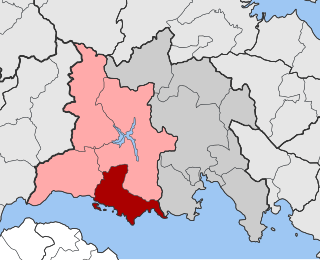
Skiritida is a former municipality in Arcadia, Peloponnese, Greece. It was formed at the 1997 Kapodistrias reform; the seat of the municipality was in Vlachokerasia. Since the 2011 local government reform it is part of the municipality Tripoli, of which it is a municipal unit. The municipal unit has an area of 186.164 km2. It had a population of 930 at the 2021 census.
Oreoi is a village and a former municipality in Euboea, Greece. It was named after the ancient town of Oreus. Since the 2011 local government reform, it is part of the municipality Istiaia-Aidipsos, of which it is a municipal unit. The municipal unit has an area of 49.913 km2 and population of 2,827 (2021). It is situated on the northwest coast of the island Euboea, by the Oreoi Strait that connects the Aegean Sea with the North Euboean Gulf. The small port Agiokampos, 5 km west of Oreoi, is served by ferries to Glyfa on the mainland.
Irakleia or Heraklia is an island and a former community in the Cyclades, Greece. Since the 2011 local government reform it is part of the municipality Naxos and Lesser Cyclades, of which it is a municipal unit. Its population was officially 148 inhabitants at the 2021 census, and its land area 17.795 square kilometres (6.9 sq mi). It is a small island between the islands of Naxos and Ios. Close to Schoinoussa, Koufonisi, Donoussa, and Keros, together they form the Lesser Cyclades. The port is called Agios Georgios, while the "capital"/chora on the top of the island is called Panagia (Madonna). The biggest caves in the Cyclades are located on Irakleia. Irakleia can be reached by ferries from Athens, Naxos and Paros.
Thesprotiko is a village and a former municipality in the Preveza regional unit, Epirus, Greece. Since the 2011 local government reform it is part of the municipality Ziros, of which it is a municipal unit. The municipal unit has an area of 131.823 km2. The village was known as Lelova (Λέλοβα) until April 1, 1927 when it adopted its current name. An independent community since 1919, Thesprotiko became a municipality in 1948.
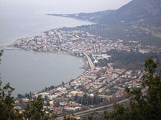
Kamena Vourla is a town and a municipality in Phthiotis, Greece. At the 2011 local government reform it became part of the municipality Molos-Agios Konstantinos, which was renamed to Kamena Vourla in July 2018. The population of the town proper was 2,796 at the 2011 census.
Tolofon is a village and a former municipality in Phocis, Greece. Since the 2011 local government reform it is part of the municipality Dorida, of which it is a municipal unit. The municipal unit has an area of 131.384 km2. The seat of the municipality was in Erateini. The ancient site of Tolophon is located in the northeastern part of the municipal unit. It is situated on the mountainous north coast of the Gulf of Corinth.
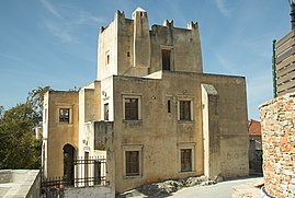
Kremasti is a town on the Greek island of Rhodes. Located on the west coast of the island, Kremasti is 12 kilometers from the capital of Rhodes, on the road to the airport. It has a population of 5,597 people and was the administrative center of the former municipality of Petaloudes.
Maza is a small village in the municipality of Apokoronas of the Chania regional unit on the island of Crete, Greece. At the time of the 2021 census, it had 104 residents. The village is perched on a mountain slope some 150 m above the valley of the Boutakas (Μπούτακας) river, 1.7 km to the south of the Chania-Rethymno road.
Neo Souli is a village in the municipality of Patras, Achaea, Greece. It is the main village of the community Souli, which consists of the villages Neo Souli, Agios Ioannis, Kefalovryso, Mintzaiika, Panagia and Profitis Ilias. Souli was part of the municipality of Patras between 1841 and 1912, and again after 1997. Between 1912 and 1997, it was an independent community.
Mavrochori is a village on the shores of Lake Orestiada in Kastoria regional unit of Macedonia, Greece.
Artemisia is a mountain village and a community in the municipality of Kalamata, Messenia, Greece. The community includes the small village Agios Ioannis Theologos. It is situated at 860 m above sea level. Many of its residents live there only during the summer months.
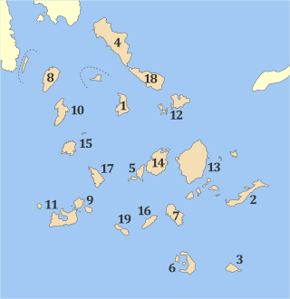
Naxos is one of the regional units of Greece. It is part of the region of South Aegean. The regional unit covers the islands of Naxos, Amorgos, Donousa, Irakleia, Schoinoussa, the Koufonisia islands and several smaller islands in the Aegean Sea.
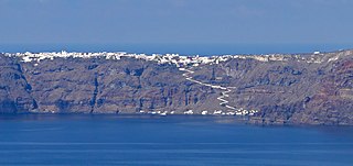
Manolas is the main settlement and the capital of Therasia, the small island opposite to Santorini (Thera). It is located in the east of island, above the abrupt Santorini caldera. It has a beautiful view of the volcano and the main settlements of Santorini such as Fira, Imerovigli, Oia, etc. Manolas can be approached either by road from the port of Riva or the uphill path from the small port of Korfos. Donkeys are the main mode of transport on this path. Manolas has a population of 140 inhabitants according to the 2021 census. It belongs to Thira municipality and Oia municipal unit.
Tsapournia is a village and a community of the Elassona municipality. Before the 2011 local government reform it was a part of the municipality of Sarantaporo, of which it was a municipal district. The community of Tsapournia covers an area of 27.197 km2.
Dimitritsi is a village in the region of Serres, northern Greece. According to the 2021 Greek census, the village had 633 inhabitants.
Rizovouni is a village and a community of Epirus in the municipality of Ziros in the Preveza regional unit. Its former name, Podogora, is of Slavic origin and means at the foot of the mountain. The late modern "Rizovouni" attributes to the Greek content of the Slavic word.
Grammatiko is a community in Pella regional unit, Macedonia, Greece. It consists of two villages: Kato Grammatiko and the smaller Ano Grammatiko.