
Half Dome is a granite dome at the eastern end of Yosemite Valley in Yosemite National Park, California. It is a well-known rock formation in the park, named for its distinct shape. One side is a sheer face while the other three sides are smooth and round, making it appear like a dome cut in half. The granite crest rises more than 4,737 ft (1,444 m) above the valley floor.

The Schilthorn is a summit in Europe, in the Bernese Alps of Switzerland. It overlooks the valley of Lauterbrunnen in the Bernese Oberland, and is the highest mountain in the range lying north of the Sefinenfurgge Pass. The Schilthorn lies above the village of Mürren, from where a cable car leads to its summit.
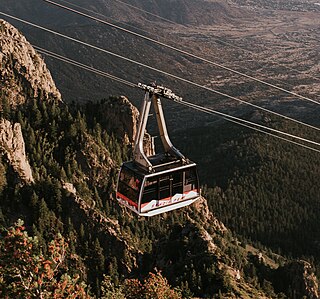
The Sandia Peak Tramway is an aerial tramway located adjacent to Albuquerque, New Mexico. It stretches from the northeast edge of the city to Sandia Peak on the ridge line of the Sandia Mountains and has the world's third longest single span. It is the longest aerial tram in the Americas, and was the longest in the world from 1966 until being surpassed in 2010.

Mayrhofen is a town in the Zillertal in the Austrian state of Tyrol. It is located approximately an hour from the Tyrolean capital city of Innsbruck.

Nam Mountain is a 262-meter (860 ft)-high peak in the Jung-gu district of south central Seoul, South Korea. Although known as Mongmyeoksan, or 목멱산 / 木覓山 in the past, it is now commonly referred to as Mt. Namsan. It offers some hiking, picnic areas and views of downtown Seoul's skyline. The N Seoul Tower is located on top of Mt. Namsan.

The West Coast Trail, originally called the Dominion Lifesaving Trail, is a 75 km (47 mi) backpacking trail following the southwestern edge of Vancouver Island in British Columbia, Canada. It was built in 1907 to facilitate the rescue of shipwrecked survivors along the coast, part of the treacherous Graveyard of the Pacific. It is now part of the Pacific Rim National Park and is often rated by hiking guides as one of the world's top hiking trails.

Fansipan is a mountain in Vietnam. The height of the mountain was 3,143 metres (10,312 ft) in 1909, but now the height of the mountain is 3,147.3 metres (10,326 ft). It is the highest mountain in the Indochinese Peninsula, hence its nickname "the Roof of Indochina". It is located in the Lào Cai Province of the Northwest region of Vietnam, 9 km (5.6 mi) southwest of Sa Pa in the Hoang Lien Son mountain range. Administratively, it is shared between Tam Đường district, Lai Châu and Sa Pa town, Lào Cai.

Jardín, often mistakingly referred to as El Jardín, is a town and municipality in the southwest region of Antioquia, Colombia. It is bounded by the Andes, Jericó, and Támesis municipalities to the north and the Caldas department to the south. The municipality is located between the San Juan river, which is called Docató by the natives, and a branch of the Western Cordillera. Jardín is identified by its preserved colonial architecture, lush vegetation, and abundant rivers and streams.

Schladming is a small former mining town in the northwest of the Austrian state of Styria that is now a popular tourist destination. It has become a large winter-sports resort and has held various skiing competitions, including most notably the FIS Alpine World Ski Championships 1982 and the FIS Alpine World Ski Championships 2013. The shopping area has many cafes and restaurants, and a variety of shops that cater to tourists.

Lenzerheide is a mountain resort in the canton of Graubünden, Switzerland at the foot of the Parpaner Rothorn. The village lies in the municipality Vaz/Obervaz in the district of Albula, sub-district Alvaschein.

Rosh HaNikra or Hanikra is a geologic formation on the border between Israel and Lebanon, located on the coast of the Mediterranean Sea, in the Western Galilee. It is a white chalk cliff face which opens up into spectacular grottos.

Katschberg Pass is a high mountain pass in the Central Eastern Alps in Austria between Rennweg am Katschberg in the state of Carinthia and Sankt Michael im Lungau in Salzburg.

Mount Ōyama, also Mount Afuri or Mount Kunimi (Kunimi-yama), is a 1,252-metre-high (4,108 ft) mountain situated on the border of Isehara, Hadano and Atsugi in Kanagawa Prefecture, Japan. Together with Mount Tanzawa and other mountains in the Tanzawa Mountains it forms the Tanzawa-Ōyama Quasi-National Park. Mount Ōyama is a popular sightseeing spot in Kanagawa Prefecture.

The North Coast Trail is a 43.1 km (26.8 mi) wilderness hiking trail in Cape Scott Provincial Park on northern Vancouver Island, British Columbia, Canada.

The Ōyama Cable Car, officially the Ōyama Cable Line, is a Japanese funicular line in Isehara, Kanagawa. This is the only line Ōyama Kankō Dentetsu operates. The company belongs to Odakyū Group. The line opened in 1931, as a route to Ōyama Afuri Shrine on Mount Ōyama. The line is now also used for hiking.

The Ebenalp is the northernmost summit of the Appenzell Alps. The mountain is a popular hiking destination and has been accessible by cable car from Wasserauen since 1955. Ebenalp attracts up to 200,000 visitors each year.

Monserrate is a high mountain over 10,000 feet high that dominates the city center of Bogotá, the capital city of Colombia. It rises to 3,152 meters (10,341 ft) above the sea level, where there is a church with a shrine, devoted to El Señor Caído.

The uKhahlamba-Drakensberg Park is a protected area in the KwaZulu-Natal province of South Africa, covering 2,428.13 km2 (938 sq mi), and is part of a world heritage site. The park includes Royal Natal National Park, a provincial park, and covers part of the Drakensberg, an escarpment formation with the highest elevations in southern Africa.

Kalinchok Bhagwati Temple is a Hindu shrine located in Kalinchok Rural Municipality in Dolkha District of Nepal.

The Len Foote Hike Inn is a sustainably designed and LEED-certified ecotourism facility located near the peak of Frosty Mountain in the Chattahoochee National Forest in Dawson County, Georgia, USA. The lodge is open year-round and is only accessible via hiking trails. Twenty rooms, a two-story central lobby, a dining room, a bathhouse, toilets, and a common room comprise the facility.


