The Solway Firth is a firth on the west coast of Great Britain, in the Irish Sea, near the Isle of Man. It forms part of the Anglo-Scottish border, lying north of Cumbria and south of Dumfries and Galloway. East to west, it stretches from St Bees Head to the Mull of Galloway.
Firth is a word in the English and Scots languages used to denote various coastal waters in the United Kingdom, predominantly within Scotland. In the Northern Isles, it more usually refers to a smaller inlet. It is linguistically cognate to fjord which has a more constrained sense in English. Bodies of water named "firths" tend to be more common on the Scottish east coast, or in the southwest of the country, although the Firth of Lorn is an exception to this. The Highland coast contains numerous estuaries, straits, and inlets of a similar kind, but not called "firth" ; instead, these are often called sea lochs. Before about 1850, the spelling "Frith" was more common.

Dumfries and Galloway is one of 32 unitary council areas of Scotland and is located in the western Southern Uplands. It comprises the historic counties of Dumfriesshire, Stewartry of Kirkcudbright and Wigtownshire, the latter two of which are collectively known as Galloway. The administrative centre is the town of Dumfries.
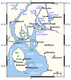
The Firth of Clyde is the mouth of the River Clyde. It is located on the west coast of Scotland and constitutes the deepest coastal waters in the British Isles. The firth is sheltered from the Atlantic Ocean by the Kintyre peninsula, which encloses the outer firth in Argyll and Ayrshire. The Kilbrannan Sound is a large arm of the Firth of Clyde, separating the Kintyre Peninsula from the Isle of Arran. Within the Firth of Clyde is another major island – the Isle of Bute. Given its strategic location at the entrance to the middle and upper Clyde, Bute played a vital naval military role during World War II.

The Firth of Forth is the estuary (firth) of several Scottish rivers including the River Forth. It meets the North Sea with Fife on the north coast and Lothian on the south.
The Firth of Tay is a firth on the east coast of Scotland, into which the River Tay empties. The firth is surrounded by four council areas: Fife, Perth and Kinross, City of Dundee, and Angus. Its maximum width is 3 mi (4.8 km).

The River Tay is the longest river in Scotland and the seventh-longest in the United Kingdom. The Tay originates in western Scotland on the slopes of Ben Lui, then flows easterly across the Highlands, through Loch Dochart, Loch Iubhair and Loch Tay, then continues east through Strathtay, in the centre of Scotland, then southeasterly through Perth, where it becomes tidal, to its mouth at the Firth of Tay, south of Dundee. It is the largest river in the UK by measured discharge. Its catchment is approximately 2,000 square miles (5,200 km2), the Tweed's is 1,500 square miles (3,900 km2) and the Spey's is 1,097 square miles (2,840 km2).
The Moray Firth is a roughly triangular inlet of the North Sea, north and east of Inverness, which is in the Highland council area of north of Scotland. It is the largest firth in Scotland, stretching from Duncansby Head in the north, in the Highland council area, and Fraserburgh in the east, in the Aberdeenshire council area, to Inverness and the Beauly Firth in the west. Therefore, three council areas have Moray Firth coastline: Highland to the west and north of the Moray Firth and Highland, Moray and Aberdeenshire to the south. The firth has more than 800 kilometres of coastline, much of which is cliff.

The River Dearne South Yorkshire, England flows roughly east for more than 30 kilometres (19 mi), from its source just inside West Yorkshire. It flows through Denby Dale, Clayton West, Darton, Barnsley, Darfield, Wath upon Dearne, Bolton on Dearne, Adwick upon Dearne and Mexborough to its confluence with the River Don at Denaby Main. Its main tributary is the River Dove, which joins it at Darfield. The river was one of those affected by the 2007 United Kingdom floods.

Ross is a region of Scotland, a former earldom and, under the name Ross-shire and, later, Ross and Cromarty, a county. The name Ross allegedly derives from a Gaelic word meaning "headland", perhaps a reference to the Black Isle. Another possible origin is the West Norse word for Orkney – Hrossey – meaning horse island; the area once belonged to the Norwegian earldom of Orkney. Ross is a historical comital region, perhaps predating the Mormaerdom of Ross. It is also a region used by the Church, with the Presbytery of Ross being part of the Synod of Ross, Sutherland and Caithness.

The River Rother, a waterway in the northern midlands of England, gives its name to the town of Rotherham and to the Rother Valley parliamentary constituency. It rises near Clay Cross in Derbyshire and flows in a generally northwards direction through the centre of Chesterfield, where it feeds the Chesterfield Canal, and on through the Rother Valley Country Park and several districts of Sheffield before joining the River Don at Rotherham in Yorkshire.

The River Nith is a river in south-west Scotland. The Nith rises in the Carsphairn hills of East Ayrshire, more precisely between Prickeny Hill and Enoch Hill, 4.4 miles (7.1 km) east of Dalmellington. For the majority of its course it flows in a southerly direction through Dumfries and Galloway and then into the Solway Firth at Airds point.
The River Eden is a river that flows through the Eden District of Cumbria, England, on its way to the Solway Firth.

The River Esk, also known as the Border Esk, is a river in Dumfries and Galloway, Scotland, that enters the English county of Cumbria and flows into the Solway Firth.

Annandale is a strath in Dumfries and Galloway, Scotland, named after the dale of the River Annan. It runs north–south through the Southern Uplands from Annanhead to Annan on the Solway Firth, and in its higher reaches it separates the Moffat hills on the east from the Lowther hills to the west. A 53-mile (85 km) long-distance walking route called Annandale Way running through Annandale was opened in September 2009.
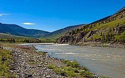
Ivvavik National Park is a national park of Canada located in Yukon. Initially named "Northern Yukon National Park," the park was renamed Ivvavik in 1992 for the Inuvialuktun word meaning "nursery" or "birthplace," in reference to the importance of the area as a calving ground for caribou. Created as a result of the Inuvialuit Final Agreement in 1984, negotiated between the Canadian Government and the Inuvialuit of the Northern Yukon, Ivvavik is the first national park in Canada to be established as a result of an aboriginal land claims agreement. About 100 people visit the park each year.

The geography of Scotland is varied, from rural lowlands to unspoilt uplands, and from large cities to sparsely inhabited islands. Located in Northern Europe, Scotland comprises the northern half of the island of Great Britain as well as 790 surrounding islands encompassing the major archipelagos of the Shetland Islands, Orkney Islands and the Inner and Outer Hebrides.

Forth Ports Limited is a port operators in the United Kingdom based in Edinburgh, Scotland. It is owned by the Public Sector Pension Investment Board.

The River Doe Lea is a river which flows near Glapwell and Doe Lea in Derbyshire, England. The river eventually joins the River Rother near Renishaw. The river contained 1,000 times the safe level of dioxins in 1991, according to a statement made by Dennis Skinner, (MP) in the House of Commons in 1992. The river flows through the site of the former Coalite plant near Bolsover, where coke, tar and industrial chemicals were manufactured until the plant closed in 2004.