
Sande is a municipality in Møre og Romsdal county, Norway. It is part of the Sunnmøre region. The administrative centre is the village of Larsnes on the island of Gurskøya. Other villages in Sande include Gursken, Sandshamn, Bringsinghaug, and Voksa.

Nordkjosbotn (Norwegian) or Gárgán (Northern Sami) is a small village in Balsfjord Municipality in Troms county, Norway. The village lies about 70 kilometres (43 mi) southeast of the city of Tromsø. Two major highways, European route E6 and European route E8, meet in this village, making it a major crossroads in Northern Norway, with an estimated annual passage of 3 million people. The 0.7-square-kilometre (170-acre) village has a population (2017) of 464 which gives the village a population density of 663 inhabitants per square kilometre (1,720/sq mi). Nordkjosbotn Church is located in this village. Macks Ølbryggeri, a brewery, has been operating in Nordkjosbotn since 2012.

Eidsvåg is a village in Nesset Municipality in Møre og Romsdal county, Norway. It is the administrative centre of the municipality. Eidsvåg is located at the end of the Langfjorden on the isthmus connecting the Romsdal peninsula to the Norwegian mainland. It is located about 8.5 kilometres (5.3 mi) southwest of the village of Raudsand, about 20 kilometres (12 mi) north of the village of Eresfjord, and 9 kilometres (5.6 mi) north of the village of Boggestranda. Nesset Church is located in this village.

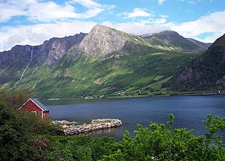
Myklebost or Syvde is a village in Vanylven Municipality in Møre og Romsdal county, Norway. The village is located at the end of the Syvdsfjorden about 12 kilometres (7.5 mi) east of the municipal center of Fiskåbygd and 16 kilometres (9.9 mi) south of the village of Rovdane. The 0.76-square-kilometre (190-acre) village has a population (2012) of 393, giving the village a population density of 517 inhabitants per square kilometre (1,340/sq mi).

Sjøvegan is the administrative centre of Salangen Municipality in Troms county, Norway. The village is located at the end of the Sagfjorden, a branch of the Salangen fjord. The river Salangselva empties into the fjord at Sjøvegan. The river flows through the lakes Nervatnet and Øvrevatnet just to the east of the village.

Aurlandsvangen is the administrative center of the municipality of Aurland in Sogn og Fjordane county, Norway. The village is located on the east side of the Aurlandsfjorden where the Aurlandselvi river flows into the fjord. The village of Undredal and the famous Nærøyfjord are located just a few kilometres to the northwest. Aurlandsvangen is located on the European route E16 highway about 10 kilometres (6.2 mi) northeast of the village of Flåm and 32 kilometres (20 mi) southwest of the village of Lærdalsøyri.

Austreim is a village in the municipality of Høyanger in Sogn og Fjordane county, Norway. The village is located on the north shore of the Sognefjorden, about 10 kilometres (6.2 mi) southwest of the municipal center of Høyanger, about 2.5 kilometres (1.6 mi) east of the village of Kyrkjebø, and about 12.5 kilometres (7.8 mi) southeast of the village of Vadheim where there is access to the European route E39 highway. The 0.37-square-kilometre (91-acre) village has a population (2013) of 359, giving the village a population density of 970 inhabitants per square kilometre (2,500/sq mi).

Byrknes is a fishing village in the municipality of Gulen in Sogn og Fjordane county, Norway. It is located on the western shore of the island of Byrknesøyna. It is about 16 kilometres (9.9 mi) southwest of the municipal center of Eivindvik, about 17 kilometres (11 mi) west of the village of Dalsøyra, and about 14 kilometres (8.7 mi) northwest of the Mongstad industrial area in neighboring Lindås and Austrheim municipalities to the south. The Sognesjøen strait is located to the northwest of the village.
Rovdane is a village in Vanylven Municipality in Møre og Romsdal county, Norway. It is located along the Rovdefjorden, about 15 kilometres (9.3 mi) north of the village of Myklebost, 27 kilometres (17 mi) northeast of the municipal center of Fiskåbygd, and 20 kilometres (12 mi) west of the village of Volda. The district around Rovdane is referred to as Rovdestranda. Rovde Church is located in Rovdane.
Syvde is a former municipality in Møre og Romsdal county, Norway. The municipality included the areas surrounding the Syvdsfjorden in the eastern part of the present-day Vanylven Municipality. The 125-square-kilometre (48 sq mi) municipality existed from 1918 until 1964. The administrative centre of the municipality was the village of Myklebost, at the end of the fjord. Syvde Church was the municipal church.

Hommelvik is the administrative centre of the municipality of Malvik in Trøndelag county, Norway. The village is located at the end of the Hommelvika, a bay off of the Trondheimsfjord. Hommelvik is about 2.5 kilometres (1.6 mi) southwest of the village of Muruvika, about 4 kilometres (2.5 mi) southeast of the village of Smiskaret, about 8 kilometres (5.0 mi) east of the village of Vikhammer, and about 10 kilometres (6.2 mi) north of the village of Sneisen. The river Homla runs north through the village, emptying into the fjord. The name of the village is derived from the river name.

Osøyro is the administrative centre of Os municipality in Hordaland county, Norway. The village lies on the southwestern part of the Bergen Peninsula, along the western shore of the Fusafjorden, about 25 kilometres (16 mi) south of the city centre of Bergen. The European route E39 highway runs through the village on its way to Bergen. There is a car ferry from the east side of Osøyro to the village of Fusa, across the Fusafjorden. Os Church is located in the village.
Olden is a village and urban area in the municipality of Stryn in Sogn og Fjordane county, Norway. Olden is located at the mouth of the Oldeelva river at the northern end of the Oldedalen valley on the southern shore of the Nordfjorden. The 0.57-square-kilometre (140-acre) village has a population (2013) of 498, giving the village a population density of 874 inhabitants per square kilometre (2,260/sq mi). Olden is located about 6 kilometres (3.7 mi) southwest of the village of Loen, about a 16 kilometres (9.9 mi) drive southeast of the municipal center of Stryn, and about 15 kilometres (9.3 mi) east of the village of Innvik.

Uskedal or Uskedalen is a village in Kvinnherad municipality in Hordaland county, Norway. The village is located in a small valley along the southern shore of the Hardangerfjorden, about 7 kilometres (4.3 mi) southwest of the village of Dimmelsvik and about 4 kilometres (2.5 mi) east of the village of Herøysund.

Rindal is the administrative centre of Rindal Municipality in Trøndelag county, Norway. The village lies along the river Surna, about 30 kilometres (19 mi) east of the village of Surnadalsøra and about 90 kilometres (56 mi) southwest of the city of Trondheim. County Road 341 branches off from County Road 340 in the village.
Åram is a village in Vanylven Municipality in Møre og Romsdal county, Norway. The village is located on the mainland, about 12 kilometres (7.5 mi) straight north of the municipal centre of Fiskåbygd. The village has a ferry quay with regular connections to the nearby islands of Kvamsøya, Voksa, and Gurskøya. Åram Church is located in the village.

Selje is the administrative centre of Selje Municipality in Sogn og Fjordane county, Norway. The village is located at the southwestern base of the Stadlandet peninsula at the entrance to the Moldefjorden. The village lies about 17 kilometres (11 mi) northeast of the town of Måløy and about 65 kilometres (40 mi) southwest of the town of Ålesund. The small island of Selja lies just off the coast of the village. The 0.65-square-kilometre (160-acre) village has a population (2013) of 651, giving the village a population density of 1,002 inhabitants per square kilometre (2,600/sq mi). Selje Church is located in the village.


