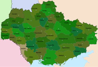
Kharkiv Oblast, also referred to as Kharkivshchyna, is an oblast (province) in eastern Ukraine.

Zmiiv or Zmiyiv from 1976 to 1990, is a city in Chuhuiv Raion, Kharkiv, Ukraine. It hosts the administration of Zmiiv urban hromada, one of the hromadas of Ukraine. The population in 2001 was 17,063, falling to 13,737.

The Udy is a river that rises in Belgorod Oblast of Russia and runs through Kharkiv Oblast of Ukraine. It is a right tributary of the Siversky Donets near Chuhuiv. Its length is 164 kilometres (102 mi). The drainage basin occupies 3,890 square kilometres (1,500 sq mi). The second largest city of Ukraine, Kharkiv, stands at the confluence of the Udy with the river Lopan.
An okruha is a historical administrative division of the Ukrainian Soviet Socialist Republic that existed between 1923 and 1930. The system was intended as a transitional system between the Russian Imperial division of governorates and the modern equivalent of oblasts.
The following gallery displays the historical and official coats of arms of Ukraine.
Zelenyi Hai may refer to several places in Ukraine:
Kharkiv Oblast is subdivided into districts (raions) which are further subdivided into territorial communities (hromadas).

Kharkiv Oblast Football Federation (HOFF) is a football governing body in the region of Kharkiv Oblast, Ukraine. The federation is a member of the Regional Council of FFU and the collective member of the FFU itself.
Borova is a rural settlement in Izium Raion, Kharkiv Oblast, Ukraine. It hosts the administration of Borova settlement hromada, one of the hromadas of Ukraine. Population: 5,055.

Pechenihy is a rural settlement in Chuhuiv Raion, Kharkiv Oblast, Ukraine. It hosts the administration of Pechenihy settlement hromada, one of the hromadas of Ukraine. Population: 4,957.
Mykhailivka may refer to several places in Ukraine:
Kivsharivka is a rural settlement in Kupiansk Raion of Kharkiv Oblast in Ukraine. It is located on the left bank of the Oskil, in the drainage basin of the Don. Kivsharivka belongs to Kupiansk urban hromada, one of the hromadas of Ukraine. Population: 17,960.
Chkalovske is a rural settlement in Chuhuiv Raion of Kharkiv Oblast in Ukraine. It is located in the steppe east of the city of Chuhuiv and west of Kupiansk. Chkalovske hosts the administration of Chkalovske settlement hromada, one of the hromadas of Ukraine. The settlement's population is 3,664
Birky is a rural settlement in Kharkiv Raion of Kharkiv Oblast in Ukraine. It is located approximately 30 kilometres (19 mi) southwest of the city of Kharkiv. Birky belongs to Nova Vodolaha settlement hromada, one of the hromadas of Ukraine. Population: 521.
Prykolotne is a rural settlement in Kupiansk Raion of Kharkiv Oblast in Ukraine. It is located in the northeast of the oblast, at the source of the Khotomlia, a left tributary of the Donets in the drainage basin of the Don. Prykolotne belongs to Vilkhuvatka rural hromada, one of the hromadas of Ukraine. Population: 1,928.

Zidky is a rural settlement in Chuhuiv Raion of Kharkiv Oblast in Ukraine. It is located on the right bank of the Donets. Zidky belongs to Zmiiv urban hromada, one of the hromadas of Ukraine. Population: 3,669.
Slobozhanske is a rural settlement in Chuhuiv Raion of Kharkiv Oblast in Ukraine. It is located in the valley of the Donets, on its left bank. Slobozhanske hosts the administration of Slobozhanske settlement hromada, one of the hromadas of Ukraine. Population: 13,675.
Blahodatne may refer to several places in Ukraine:

The 113th Independent Brigade of the Territorial Defense Forces is a military formation of the Territorial Defense Forces of Ukraine in Kharkiv Oblast. It is part of Operational Command East.


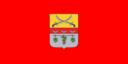
 Berestyn City