
Cheshire is a county in North West England, bordering Merseyside and Greater Manchester to the north, Derbyshire to the east, Staffordshire and Shropshire to the south and Flintshire, Wales and Wrexham county borough to the west. Cheshire's county town is the City of Chester (118,200); the largest town is Warrington (209,700).
Other major towns include Crewe (71,722), Ellesmere Port (55,715), Macclesfield (52,044), Northwich (75,000), Runcorn (61,789), Widnes (61,464) and Winsford (32,610)

The counties of Ireland are sub-national divisions that have been, and in some cases continue to be, used to geographically demarcate areas of local government. These land divisions were formed following the Norman invasion of Ireland in imitation of the counties then in use as units of local government in the Kingdom of England. The older term "shire" was historically equivalent to "county". The principal function of the county was to impose royal control in the areas of taxation, security and the administration of justice at the local level. Cambro-Norman control was initially limited to the southeastern parts of Ireland; a further four centuries elapsed before the entire island was shired. At the same time, the now obsolete concept of county corporate elevated a small number of towns and cities to a status which was deemed to be no less important than the existing counties in which they lay. This double control mechanism of 32 counties plus 10 counties corporate remained unchanged for a little over two centuries until the early 19th century. Since then, counties have been adapted and in some cases divided by legislation to meet new administrative and political requirements.

Long Island is a densely populated island off the East Coast of the United States, beginning at New York Harbor approximately 0.35 miles (0.56 km) from Manhattan Island and extending eastward into the Atlantic Ocean. The island comprises four counties in the U.S. state of New York. Kings and Queens Counties and Nassau County share the western third of the island, while Suffolk County occupies the eastern two-thirds. More than half of New York City's residents now live on Long Island, in Brooklyn and Queens. However, many people in the New York metropolitan area colloquially use the term Long Island to refer exclusively to Nassau and Suffolk Counties, which are mainly suburban in character, conversely employing the term the City to mean Manhattan alone.

Orange County is located in the Los Angeles metropolitan area in the U.S. state of California. As of the 2010 census, the population was 3,010,232, making it the third-most populous county in California, the sixth-most populous in the United States, and more populous than 21 U.S. states. Its county seat is Santa Ana. It is the second most densely populated county in the state, behind San Francisco County. The county's four largest cities by population, Anaheim, Santa Ana, Irvine, and Huntington Beach, each have a population exceeding 200,000. Several of Orange County's cities are on the Pacific Ocean western coast, including Huntington Beach, Newport Beach, Laguna Beach, Dana Point, and San Clemente.

Westchester County is a county in the U.S. state of New York. It is the second-most populous county on the mainland of New York, after the Bronx, and the most populous county in the state north of New York City. According to the 2010 Census, the county had a population of 949,113, estimated to have increased by 3.3% to 980,244 by 2017. Situated in the Hudson Valley, Westchester covers an area of 450 square miles (1,200 km2), consisting of six cities, 19 towns, and 23 villages. Established in 1683, Westchester was named after the city of Chester, England. The county seat is the city of White Plains, while the most populous municipality in the county is the city of Yonkers, with an estimated 200,807 residents in 2016.

Lancashire is a ceremonial county in North West England. The administrative centre is Preston. The county has a population of 1,449,300 and an area of 1,189 square miles (3,080 km2). People from Lancashire are known as Lancastrians.
A county seat is an administrative center, seat of government, or capital city of a county or civil parish. The term is used in Canada, China, Romania, Taiwan and the United States. County towns have a similar function in the United Kingdom and Republic of Ireland, and historically in Jamaica.

Southern California is a geographic and cultural region that generally comprises California's southernmost counties, and is the second most populous urban agglomeration in the United States. The region is traditionally described as eight counties, based on demographics and economic ties: Imperial, Los Angeles, Orange, Riverside, San Bernardino, San Diego, Santa Barbara, and Ventura. The more extensive 10-county definition, which includes Kern and San Luis Obispo counties, is also used and is based on historical political divisions.

Los Angeles County, officially the County of Los Angeles, is the most populous county in the Los Angeles metropolitan area of the U.S. state of California and is the most populous county in the United States, with more than 10 million inhabitants as of 2017. As such, it is the largest non–state level government entity in the United States. Its population is larger than that of 41 individual U.S. states. It is the third-largest metropolitan economy in the world, with a Nominal GDP of over $700 billion—larger than the GDPs of Belgium, Saudi Arabia, Norway, and Taiwan. It has 88 incorporated cities and many unincorporated areas and, at 4,083 square miles (10,570 km2), it is larger than the combined areas of Delaware and Rhode Island. The county is home to more than one-quarter of California residents and is one of the most ethnically diverse counties in the U.S. Its county seat, Los Angeles, is also California's most populous city and the nation's second largest city with about 4 million people.

San Bernardino County, officially the County of San Bernardino, is a county located in the southern portion of the U.S. state of California, and is located within the Greater Los Angeles area. As of the 2010 U.S. Census, the population was 2,035,210, making it the fifth-most populous county in California, and the 12th-most populous in the United States. The county seat is San Bernardino.

In the United States, an administrative or political subdivision of a state is a county, which is a region having specific boundaries and usually some level of governmental authority. The term "county" is used in 48 U.S. states, while Louisiana and Alaska have functionally equivalent subdivisions called parishes and boroughs respectively.

Middlesex is an ancient county in southeast England. It is now entirely within the wider urbanised area of London. Its area is now also mostly within the ceremonial county of Greater London, with small sections in other neighbouring ceremonial counties. It was established in the Anglo-Saxon system from the territory of the Middle Saxons, and existed as an official unit until 1965. The historic county includes land stretching north of the River Thames from 17 miles (27 km) west to 3 miles (5 km) east of the City of London with the rivers Colne and Lea and a ridge of hills as the other boundaries. The largely low-lying county, dominated by clay in its north and alluvium on gravel in its south, was the second smallest county by area in 1831.
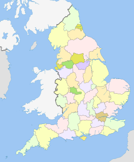
The counties of England are areas used for different purposes, which include administrative, geographical, cultural and political demarcation. The term 'county' is not clearly defined and can apply to similar or the same areas used by each of these demarcation structures. These different types of county each have a more formal name but are commonly referred to just as 'counties'. The current arrangement is the result of incremental reform.
The ceremonial counties, also referred to as the lieutenancy areas of England, are areas of England to which a Lord Lieutenant is appointed. Legally the areas in England, as well as in Wales and Scotland, are defined by the Lieutenancies Act 1997 as counties and areas for the purposes of the lieutenancies in Great Britain, in contrast to the areas used for local government. They are also informally known as geographic counties, as often representing more permanent features of English geography, and to distinguish them from counties of England which have a present-day administrative function.

New York City encompasses five county-level administrative divisions called boroughs: The Bronx, Brooklyn, Manhattan, Queens, and Staten Island. All boroughs are part of New York City, and each of the boroughs is coextensive with a respective county, the primary administrative subdivision within New York state. Queens and the Bronx are concurrent with the counties of the same name, while Manhattan, Brooklyn, and Staten Island correspond to New York, Kings, and Richmond counties respectively.

Essex is a county in the south-east of England, north-east of London. One of the home counties, it borders Suffolk and Cambridgeshire to the north, Hertfordshire to the west, Kent across the estuary of the River Thames to the south, and London to the south-west. The county town is Chelmsford, the only city in the county. For government statistical purposes Essex is placed in the East of England region.


