
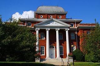
Clay County is a county located in the far western part of U.S. state North Carolina. As of the 2020 census, the county population was 11,089. The county seat is Hayesville.

Warren County is a county located in the northeastern Piedmont region of the U.S. state of North Carolina, on the northern border with Virginia, made famous for a landfill and birthplace of the environmental justice movement. As of the 2020 census, its population was 18,642. Its county seat is Warrenton. It was a center of tobacco and cotton plantations, education, and later textile mills.
Stokes County is a county located in the U.S. state of North Carolina. As of the 2020 census, the population was 44,520. Its county seat is Danbury.

Sampson County is a county located in the U.S. state of North Carolina. As of the 2020 census, the population was 59,036. Its county seat is Clinton.

Rockingham County is a county located in the U.S. state of North Carolina. As of the 2020 census, the population was 91,096. Its county seat is Wentworth. The county is known as "North Carolina's North Star".

Iredell County is a county located in the U.S. state of North Carolina. As of the 2020 census, the population was 186,693. Its county seat is Statesville, and its largest community is Mooresville. The county was formed in 1788, subtracted from Rowan County. It is named for James Iredell, one of the first justices of the Supreme Court. Iredell County is included in the Charlotte-Concord-Gastonia, NC-SC Metropolitan Statistical Area, as defined by the Office of Management and Budget, with data from the U.S. Census Bureau.

Durham County is a county located in the U.S. state of North Carolina. As of the 2020 census, the population was 324,833, making it the sixth-most populous county in North Carolina. Its county seat is Durham, which is the only incorporated municipality predominantly in the county, though very small portions of cities and towns mostly in neighboring counties also extend into Durham County. The central and southern parts of Durham County are highly urban, consisting of the city as well as several unincorporated suburbs. Southeastern Durham County is dominated by the Research Triangle Park, most of which is in Durham County. The northern third of Durham County is rural in nature.
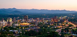
Asheville is a city in and the county seat of Buncombe County, North Carolina, United States. Located at the confluence of the French Broad and Swannanoa rivers, it is the most populous city in Western North Carolina, and the state's 11th-most-populous city. According to the 2020 census, the city's population was 94,589, up from 83,393 in the 2010 census. It is the principal city in the three-county Asheville metropolitan area, which had an estimated population of 417,202 in 2023.

Pembroke is a town in Robeson County, North Carolina, United States. It is about 90 miles inland and northwest from the Atlantic Coast. The population was 2,823 at the 2020 census. The town is the seat of the state-recognized Lumbee Tribe of North Carolina, as well as the home of the University of North Carolina at Pembroke.

The Research Triangle, or simply The Triangle, are both common nicknames for a metropolitan area in the Piedmont region of the U.S. state of North Carolina. Anchored by the cities of Raleigh and Durham and the town of Chapel Hill, the region is home to three major research universities: North Carolina State University, Duke University, and the University of North Carolina at Chapel Hill, respectively. The "Triangle" name originated in the 1950s with the creation of Research Triangle Park located between the three anchor cities, which is the largest research park in the United States and home to numerous high tech companies.

Most U.S. states and territories have at least two tiers of local government: counties and municipalities. Louisiana uses the term parish and Alaska uses the term borough for what the U.S. Census Bureau terms county equivalents in those states. Civil townships or towns are used as subdivisions of a county in 20 states, mostly in the Northeast and Midwest.
The Piedmont & Northern Railway was a heavy electric interurban company operating over two disconnected divisions in North and South Carolina. Tracks spanned 128 miles (206 km) total between the two segments, with the northern division running 24 miles (39 km) from Charlotte, to Gastonia, North Carolina, including a three-mile (5 km) spur to Belmont. The southern division main line ran 89 miles (143 km) from Greenwood to Spartanburg, South Carolina, with a 12 mi (19 km) spur to Anderson. Initially the railroad was electrified at 1500 volts DC, however, much of the electrification was abandoned when dieselisation was completed in 1954.

Carova Beach or Carova is an unincorporated community in Currituck County in the extreme northeastern corner of North Carolina, United States. The community, begun in the 1960s, is found on Currituck Banks, north of Bodie Island, and can be accessed only by boat or by four-wheel drive vehicle. There are no paved roads connecting Carova to the town of Corolla, North Carolina. The neighboring settlement of Sandbridge in Virginia Beach, Virginia, is not accessible by vehicle from Carova. In the 1960s, when development began in Carova, there were plans to construct a paved road from Sandbridge south to Carova through the Back Bay National Wildlife Refuge, but these never materialized. Today, there is a permanent fence from ocean to sound to keep vehicles from crossing and, more importantly, to keep the feral horses from migrating to the Virginia side of the border. To reach Carova, four-wheel drive vehicles must drive north along the beach from Corolla into the community, as access from Virginia is limited to pedestrians and bicyclists.

Eastern North Carolina is the region encompassing the eastern tier of North Carolina, United States. It is known geographically as the state's Coastal Plain region. Primary subregions of Eastern North Carolina include the Sandhills, the Lower Cape Fear, the Crystal Coast, the Inner Banks and the Outer Banks. It is composed of the 41 most eastern counties in the state. Cities include Greenville, Jacksonville, Wilmington, Rocky Mount and North Carolina's first capital New Bern.

Brasstown is an unincorporated community located mostly within Clay County, North Carolina, United States, though roughly one third of Brasstown is within the adjacent Cherokee County. Brasstown Creek travels through the community and separates the two counties.
Lucideon is an independent materials development, testing and assurance company based in Stoke-on-Trent and in the UK. Lucideon owns testing facilities around the world.
Layman is an unincorporated community in northeastern Fairfield Township, Washington County, Ohio, United States. It lies where Brownrigg Road and Tick Ridge Road intersect with State Route 550.
Mill Bridge is an unincorporated community and populated place officially registered as Mill Bridge in 1874. It is located primarily in Atwell Township and Steele Township in Rowan County, North Carolina, United States. With part extending into Mount Ulla Township. The prominent features include the Kerr Mill, Thyatira Presbyterian Church, and Millbridge Speedway.

