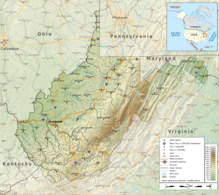
Princeton, is a city in and the county seat of Mercer County, West Virginia, United States. The city is coined the "Heart of Mercer County" or the "Jewel of the South" in past decades. The population was 6,432 at the 2010 census with approximately 35,000 residents living in the greater Princeton area. It is part of the Bluefield, WV-VA micropolitan area which has a population of 107,342. The city hosts the Princeton WhistlePigs baseball club of the Appalachian League. A main tourist destination of the city is the Mercer Street Grassroots District located in Downtown Princeton. This area has been revitalized and is now home to cafes, restaurants, shops, and artistic venues.

The Allegheny Mountain Range, informally the Alleghenies, is part of the vast Appalachian Mountain Range of the Eastern United States and Canada and posed a significant barrier to land travel in less developed eras. The Allegheny Mountains have a northeast–southwest orientation, running for about 400 miles (640 km) from north-central Pennsylvania, southward through western Maryland and eastern West Virginia.

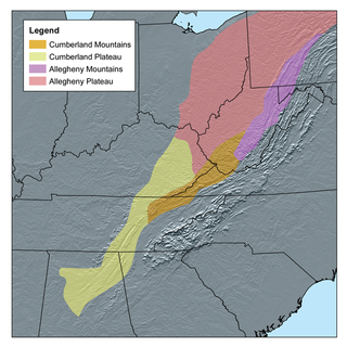
The Cumberland Plateau is the southern part of the Appalachian Plateau in the Appalachian Mountains of the United States. It includes much of eastern Kentucky and Tennessee, and portions of northern Alabama and northwest Georgia. The terms "Allegheny Plateau" and the "Cumberland Plateau" both refer to the dissected plateau lands lying west of the main Appalachian Mountains. The terms stem from historical usage rather than geological difference, so there is no strict dividing line between the two. Two major rivers share the names of the plateaus, with the Allegheny River rising in the Allegheny Plateau and the Cumberland River rising in the Cumberland Plateau in Harlan County, Kentucky.

The Ridge-and-Valley Appalachians, also called the Ridge and Valley Province or the Valley and Ridge Appalachians, are a physiographic province of the larger Appalachian division and are also a belt within the Appalachian Mountains extending from southeastern New York through northwestern New Jersey, westward into Pennsylvania and southward into Maryland, West Virginia, Virginia, Kentucky, Tennessee, Georgia and Alabama. They form a broad arc between the Blue Ridge Mountains and the Appalachian Plateau physiographic province. They are characterized by long, even ridges, with long, continuous valleys in between.

The Allegheny Front is the major southeast- or east-facing escarpment in the Allegheny Mountains in southern Pennsylvania, western Maryland, eastern West Virginia, and western Virginia, USA. The Allegheny Front forms the boundary between the Ridge-and-Valley Appalachians to its east and the Appalachian Plateau to its west. The Front is closely associated with the Appalachian Mountains' Eastern Continental Divide, which in this area divides the waters of the Ohio/Mississippi river system, flowing to the Gulf of Mexico, from rivers flowing into Chesapeake Bay and from there into the Atlantic Ocean.
Page is a census-designated place (CDP) and coal town in Fayette County, West Virginia, United States. As of the 2010 census, its population was 224. It was named for William Nelson Page (1854-1932), a civil engineer and industrialist who lived in nearby Ansted, where he managed Gauley Mountain Coal Company and many iron, coal, and railroad enterprises.
The Potomac Highlands of West Virginia centers on five West Virginian counties in the upper Potomac River watershed in the western portion of the state's Eastern Panhandle, bordering Maryland and Virginia. Because of geographical proximity, similar topography and landscapes, and shared culture and history, the Potomac Highlands region also includes Pocahontas, Randolph, and Tucker counties, even though they are in the Monongahela River or New River watersheds and not that of the Potomac River.

Shavers Fork Mountain Complex is the name given to the mountains on either side of Shavers Fork in the highlands portions of Randolph County, Pocahontas County, and Tucker County in West Virginia, USA. Much of the land surrounding the river and its adjacent mountains is protected by Monongahela National Forest including about 20,000 acres (81 km2) of designated wilderness.

Cheat Mountain is an exceptionally high and rugged ridge situated in the Allegheny Mountains of eastern West Virginia, USA. It is about 50 miles (80 km) long and more than five miles (8 km) wide at its widest. Its highest point is at its southernmost end at Thorny Flat, which has an elevation of 4,848 feet (1,478 m). Several other knobs rise above 4,000 feet (1,200 m) along its length.

The Environment of West Virginia encompasses terrain and ecosystems ranging from plateaus to mountains. Most of West Virginia lies within the Appalachian mixed mesophytic forests ecoregion, while the higher elevations along the eastern border and in the panhandle lie within the Appalachian-Blue Ridge forests.

Allegheny Mountain is a major mountain ridge in the southern range of the Allegheny Mountains, part of the Appalachian Mountains. It forms the Eastern Continental Divide along part of its course and also serves as part of the Virginia-West Virginia state line.

North Fork Mountain is a quartzite-capped mountain ridge in the Ridge and Valley physiographic province of the Allegheny Mountains of eastern West Virginia, USA. Kile Knob, at 4,588 feet, is the mountain's highest point, and Panther Knob and Pike Knob are nearly as high.

Winterplace Ski Resort is a ski resort located in Ghent, West Virginia on Raleigh County's Flat Top Mountain. The southernmost ski resort in West Virginia, Winterplace is a popular attraction due to its proximity to Interstate 77. It operates in conjunction with The Resort at Glade Springs, a four season golf resort and spa.

Back Allegheny Mountain is a long mountain ridge in eastern West Virginia. It is part of the Shavers Fork Mountain Complex in the Allegheny Range of the Appalachians.

The Pennsylvanian Pottsville Formation is a mapped bedrock unit in Pennsylvania, western Maryland, West Virginia, Ohio, and Alabama. It is a major ridge-former in the Ridge-and-Valley Appalachians of the eastern United States. The Pottsville Formation is conspicuous at many sites along the Allegheny Front, the eastern escarpment of the Allegheny or Appalachian Plateau.

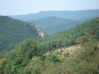
Spruce Mountain, in eastern West Virginia, USA, is the highest ridge of the Allegheny Mountains. The "whale-backed" ridge extends for only about 16 miles (26 km), from northeast to southwest, but several of its peaks exceed 4,500 feet (1,400 m) in elevation. The summit, Spruce Knob, is celebrated as the highest point in the state as well as the range, which covers parts of four states.
The Allegheny Parkway was a proposed 632-mile (1,017 km) scenic highway, intended to extend from Harpers Ferry, West Virginia, to the Cumberland Gap, to be managed by the National Park Service. It was seen as a complementary project to the Skyline Drive and Blue Ridge Parkway on the east side of the Shenandoah Valley. Despite support from the Park Service, authorizing legislation was never passed and it was never built.
The Yew Mountains are a mountain ridge in Southern West Virginia that locally forms the boundary between the Allegheny Plateau to the northwest and the Ridge-and-Valley Appalachians to the southeast. It is part of the Allegheny Mountains, and contains some of the highest peaks in West Virginia. Its highest point is 4,703 feet (1,433 m) at Red Spruce Knob near its northern edge, named for the stand of red spruce at its summit, which is also the highest point of the Highland Scenic Highway, and the ninth highest peak in West Virginia. Other peaks include Black Mountain, Jacox Knob, Briery Knob, and Blue Knob. The Cranberry Wilderness of Monongahela National Forest, and the Yew Mountain Center, are within the range. There is a proposal to create a Birthplace of Rivers National Monument in the area.
The Princeton–Deepwater District is a rail line in West Virginia that connects Deep Water, West Virginia on the Kanawha River southwards to Princeton, West Virginia and beyond to rail lines leading to Virginia. It is known for its rugged terrain and opportunities for rail photography.


