
Perry County is a county located in the U.S. state of Tennessee. As of the 2020 census, the population was 8,366, with an average population density of 20.2 persons per square mile, making it the least densely populated county in Tennessee. Its county seat and largest town is Linden. The county is named after American naval commander and War of 1812 hero Oliver Hazard Perry.

Jefferson County, Arkansas is a county located in the U.S. state of Arkansas in the area known as the Arkansas Delta that extends west of the Mississippi River. Jefferson County consists of five cities, two towns, and 20 townships. The county is bisected by the Arkansas River, which was critical to its development and long the chief transportation byway. In 2020, Jefferson County's population was estimated at 67,260. Its county seat and largest city is Pine Bluff. Jefferson County is included in the Pine Bluff metropolitan statistical area. The county seat and the most populous city is Pine Bluff.

Altheimer is a city in Plum Bayou Township, Jefferson County, Arkansas, United States. It is situated on the Union Pacific Railway, 11 miles (18 km) northeast of Pine Bluff. As of the 2010 census it had a population of 984, down from 1,192 at the 2000 census. As of 2018 the estimated population was 829 and was down to 696 in the 2020 Census, with zero change estimated in 2021 and 2022.

Flatwoods is a home rule-class city in Greenup County, Kentucky, United States. The population was 7,325 at the 2020 census, making it the largest city in Greenup County. Flatwoods is a part of the Huntington–Ashland metropolitan area. Locally, Flatwoods is considered to be a bedroom community, as it has no large employer within the city. Many residents work for CSX Transportation, Marathon Petroleum, or King's Daughters Medical Center.

Bly is an unincorporated community in Klamath County, Oregon, United States. By highway, it is about 50 miles (80 km) east of Klamath Falls. As of 2020, the population was 207.

The Buffalo River is the longest unimpounded river in Middle Tennessee in the United States. It flows 125 miles (201 km) through the southern and western portions of that region. The Buffalo is the largest tributary of the Duck River. Canoeing is popular, especially in its middle section. The river is named for the Buffalo fish which was abundant when the first European settlers arrived.

New York State Route 246 (NY 246) is a 10.44-mile-long (16.80 km) north–south state highway located in western New York in the United States. All but 0.09 miles (0.14 km) of the route are located in Wyoming County; the northernmost intersection on the highway is in Genesee County instead. The southern terminus of the route is at an intersection with NY 39 in the village of Perry and its northern terminus is at a junction with NY 63 in the town of Pavilion. NY 246 intersects U.S. Route 20A (US 20A) north of Perry village and also passes through the town of Covington.

New York State Route 245 (NY 245) is a state highway in the Finger Lakes region of New York in the United States. The southern terminus of the route is at NY 21 in Naples. The northern terminus is at NY 5, U.S. Route 20 and NY 14A west of Geneva. From Geneva to Naples, NY 245 traverses the land from the north end of Seneca Lake to the south end of Canandaigua Lake in roughly a northeast to southwest direction.

Gallant, also known as Clear Springs or Greasy Cove, is a census-designated place and unincorporated community in Etowah, and St. Clair counties, Alabama, United States. It lies west of the city of Gadsden, the county seat of Etowah County. As of the 2010 census, its population was 855. It has a post office with the ZIP code 35972.
Waverly is a census-designated place (CDP) in northeastern Wood County, West Virginia, United States. As of the 2010 census, its population was 395. It lies along the Ohio River on West Virginia Route 2, northeast of the city of Parkersburg, the county seat of Wood County. Its elevation is 620 feet (189 m). It has a post office with the ZIP code 26184.
North Springs is an unincorporated community in northwestern Jackson County, Tennessee, United States. It lies along Tennessee State Routes 56 and 151, northwest of the town of Gainesboro, the county seat of Jackson County. Its elevation is 604 feet (184 m).

Austinville is an unincorporated community in southwestern Butler County, Iowa, United States. It lies along Iowa Highway 57 southwest of the city of Allison, the county seat of Butler County. Its elevation is 1,001 feet (305 m). Although Austinville is unincorporated, it has a post office with the ZIP code of 50608, which opened on 3 October 1892. In 2022, the population was 100 in town and the surrounding area.
McPaul is a former townsite and unincorporated community in Fremont County, Iowa, United States. It was located at the intersection of County Roads J18 and L31, near the Missouri River. It is three miles west of Thurman, at 40.887295N -95.7950145W.
Flatwoods is a term in forestry.

K-49 is a 35.354-mile-long (56.897 km) north–south state highway in the U.S. state of Kansas. K-49 begins at U.S. Route 81 (US-81) in Caldwell, and runs north to K-42 in Viola. Along the way, K-49 has a brief overlap with US-160 south of Conway Springs. The majority of the route exists in Sumner County, with only a mile existing in Sedgwick County.
Weston is a census-designated place located in the southeastern portion of Hazel Dell Township in Pottawattamie County in the state of Iowa. As of the 2020 census the population was 78.
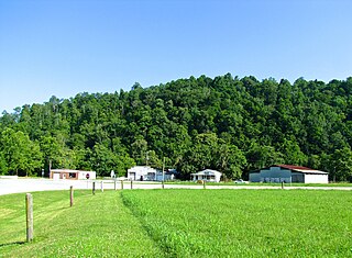
The Dr. Richard Calvin Bromley House, also known as Hotel Bromley, is a historic house in Flatwoods, Tennessee, U.S..
Natchez Trace is a 1960 American film starring Zachary Scott, Marcia Henderson, and William Campbell, produced by Lloyd Royal and Tom Garraway, and directed by Alan Crosland Jr. The now-lost film was based on a novel of the same name by William Bradford Huie.
Balfour is an unincorporated community in Mills County, in the U.S. state of Iowa.
Bromley is a former village in Minerva Township, Marshall County, Iowa, United States.


