
Hans Dülfer was a German mountain climber.

The Karwendel is the largest mountain range of the Northern Limestone Alps. It is located on the Austria–Germany border. The major part belongs to the Austrian federal state of Tyrol, while the adjacent area in the north is part of Bavaria, Germany. Four chains stretch from west to east; in addition, there are a number of fringe ranges and an extensive promontory (Vorkarwendel) in the north.

The Central Eastern Alps, also referred to as Austrian Central Alps or just Central Alps, comprise the main chain of the Eastern Alps in Austria and the adjacent regions of Switzerland, Liechtenstein, Italy and Slovenia. South them is the Southern Limestone Alps.

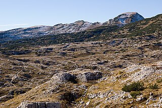
Hoher Dachstein is a strongly karstic mountain in central Austria and the second-highest mountain in the Northern Limestone Alps. It is situated at the border of Upper Austria and Styria, and is the highest point in each of those states. Parts of the massif also lie in the state of Salzburg, leading to the mountain being referred to as the Drei-Länder-Berg.

Jezercë is the highest peak in the Dinaric Alps, the second highest in Albania and the sixth highest in Southeast Europe, standing at 2,694 m (8,839 ft) above sea level. It is the 28th most prominent mountain peak in Europe, and is regarded as one of the toughest and most dangerous climbs in the Albanian Alps.

The Allgäu Alps are a mountain range in the Northern Limestone Alps, located on the Austria–Germany border, which covers parts of the German states of Bavaria and Baden-Württemberg and the Austrian states of Tyrol and Vorarlberg. The range lies directly east of Lake Constance.

The Chiemgau Alps are a mountain range in the Northern Limestone Alps and belong to the Eastern Alps. They are crossed by the Austria–Germany border: their major part is situated in Bavaria, Germany, and only a small section crosses the Austrian border into the states of Salzburg and Tirol. They reach their highest elevation in the Sonntagshorn, a peak straddling the German-Austrian border.

The Wetterstein mountains, colloquially called Wetterstein, is a mountain group in the Northern Limestone Alps within the Eastern Alps, crossing the Austria–Germany border. It is a comparatively compact range located between Garmisch-Partenkirchen, Mittenwald, Seefeld in Tirol and Ehrwald along the border between Germany (Bavaria) and Austria (Tyrol). Zugspitze, the highest peak is at the same time the highest mountain in Germany.
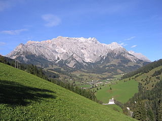
The Berchtesgaden Alps are a mountain range of the Northern Limestone Alps, named after the market town of Berchtesgaden located in the centre. It is crossed by the Austria–Germany border: the central part belongs to the Berchtesgadener Land district of southeastern Bavaria, Germany, while the adjacent area in the north, east and south is part of the Austrian state of Salzburg.

The Kaiser Mountains are a mountain range in the Northern Limestone Alps and Eastern Alps. Its main ridges – are the Zahmer Kaiser and south of it the Wilder Kaiser. The mountains are situated in the Austrian province of Tyrol between the town of Kufstein and the town of St. Johann in Tirol. The Kaiser Mountains offer some of the loveliest scenery in all the Northern Limestone Alps.

The Jôf di Montasio is a mountain located in the Province of Udine, in the Friuli-Venezia Giulia region of northeastern Italy.
The Limestone Alps are sub-mountain range of the Alps in Central Europe.

The Totenkirchl is mountain, 2,190 m high, in the Wilder Kaiser range in the Northern Limestone Alps in Austria, east of Kufstein in Tyrol.

The Predigtstuhl is a 2,116-metre (6,942 ft) high mountain in the Wilder Kaiser range in the Northern Limestone Alps in Austria, east of Kufstein in the Tyrol.
Cima Dodici is a mountain on the border of Vicenza in Veneto and Trentino in Trentino Alto Adige, northern Italy, south of the village of Borgo Valsugana. It has an elevation of 2,336 metres. and is the highest peak in Vicenza. At 1,874 m prominence, it is an ultra prominent peak. The key col is near the village of Pergine Valsugana.

The Gutenstein Alps are a mountain range in the Eastern Alps in Central Europe, and the northeasternmost part of the Northern Limestone Alps, reaching heights over 1,000 m.

The Alpine Club classification of the Eastern Alps is a common division of the Eastern Alps into 75 mountain ranges, based on the Moriggl Classification (ME) first published in 1924 by the German and Austrian Alpine Club. The present-day division established for the German-speaking world was compiled by the German, Austrian and South Tyrol Alpine Clubs and published in 1984 and is also used for the basic numbering of Alpine Club maps for mountaineering.

The Stripsenjochhaus is an Alpine club hut owned by the Kufstein branch of the Austrian Alpine Club in the Kaisergebirge mountain range in the Austrian state of Tyrol.
The Goinger Halt is a mountain in the Kaisergebirge range in the Northern Limestone Alps in Austria. It has a double summit: a northern top to the rear, the Hintere Goinger Halt, and a higher, southern top in front, the Vordere Goinger Halt. The name "Halt" means something like Alpine meadow and refers therefore to the peak over the meadow areas, that belong to the parish of Going.

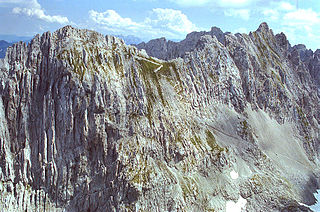
The Karlspitzen is a twin-peaked mountain in the middle of the Kaisergebirge range of the Northern Limestone Alps in Austria. The two peaks are the northern Hintere Karlspitze and the southern Vordere Karlspitze with its summit cross; they are linked by a sharp, exposed, rocky arête. Seen from the south the Vordere Karlspitze is a huge and very prominent block of rock, whereas the Hintere Karlspitze is hidden behind other (lower) neighbouring mountains.

