
State Road 80 is a 123.5 miles (198.8 km) route linking US 41 Business in Fort Myers and State Road A1A in Palm Beach. The road is the northernmost of three linking Southwest Florida to South Florida via the Everglades. Due to increasing traffic, State Road 80 has experienced upgrades and widening in various sections since 2000.

State Road 29 is a state highway that runs north–south through Southwest Florida. It begins in Carnstown and runs north to a point just south of Palmdale. A rural road, it runs mostly through uninhabited farmland in its northern half, and along wetlands in its southern half. The route previously continued south of Carnestown to Everglades City and Chokoloskee, which has since become County Road 29.

State Road 845 (SR 845), locally known as Powerline Road, is a 16.314-mile-long (26.255 km) north–south divided highway serving northern Broward County and southern Palm Beach County, Florida, United States. The route extends from an intersection with Sunrise Boulevard (SR 838) near downtown Ft. Lauderdale, north to an intersection with Glades Road (SR 808) near Boca Raton.

Stretching 148 miles (238 km) across the Florida peninsula, State Road 70 spans five Florida counties and straddles the northern boundaries of two more. Its western terminus is at US 41 south of Bradenton ; its eastern terminus is an intersection of Virginia Avenue and South Fourth Street in Fort Pierce.

State Road 78 is the Florida Department of Transportation designation of the highway that historically extended from Pine Island Center on the Gulf Coast of Florida to the northern tip of Lake Okeechobee. In the 1980s, two segments of the route were removed from state maintenance to county maintenance and both were redesignated County Road 78. All three sections of SR 78 are signed east–west, even though the easternmost section is actually a north–south route.
State Road 884, along with County Road 884, together create Lee County, Florida's primary east–west partially controlled access highway, linking Cape Coral in the western portion of the county to Lehigh Acres and Alva in the eastern portion. Currently, the highway consists of State Road 884, and two segments of County Road 884 on each end, and the entire highway is about 37.5 miles (60.4 km) long. The highway runs through the southern incorporated limits of the city of Fort Myers and through the mid part of Cape Coral, and has become a major commuter route.

State Road 82 is a 29-mile-long east–west highway serving northern Lee and Collier County, Florida. The western terminus is an intersection with Cleveland Avenue in Fort Myers; the eastern terminus is an intersection with SR 29 midway between Immokalee and Felda.
State Road 865 and County Road 865 are a series of roads serving Lee County, Florida. Originally a continuous state road extending from Bonita Springs to Tice by way of Fort Myers Beach and Fort Myers, SR 865 now consists of two segments connected by a part of CR 865, which also extends to the north and south of the state segments. Both the state and county controlled segments of the route combined stretch a distance of over 40 miles (64.37 km), making it the longest designation in Lee County.

State Road 867 and County Road 867 together create a 14.6-mile (23.5 km) long road known as McGregor Boulevard in Lee County, Florida, paralleling the Caloosahatchee River between Punta Rassa and Fort Myers. The entire road was formerly state-maintained.
State Road 739 is a 17-mile-long (27 km) commercial highway running from San Carlos Park, Florida to North Fort Myers that is also known as U.S. Route 41 Business for the northernmost six miles (9.7 km) of its route.

U.S. Highway 1 (US 1) in Florida runs 545 miles (877 km) along the state's east coast from Key West to its crossing of the St. Marys River into Georgia north of Boulogne and south of Folkston. US 1 was designated through Florida when the U.S. Numbered Highway System was established in 1926. With the exception of Monroe County, the highway runs through the easternmost tier of counties in the state, connecting numerous towns and cities along its route, including nine county seats. The road is maintained by the Florida Department of Transportation (FDOT).
State Road 72 is a state highway in DeSoto and Sarasota County, Florida. It is the most direct route to Siesta Key when traveling west on SR 70 from Arcadia and Fort Pierce.

U.S. Highway 27 (US 27) in Florida is a north–south United States Numbered Highway. It runs 496.352 miles (798.801 km) from the Miami metropolitan area northwest to the Tallahassee metropolitan area. Throughout the state, US 27 has been designated the Claude Pepper Memorial Highway by the Florida Legislature. It was named after long-time Florida statesperson Claude Pepper, who served in both the U.S. Senate and House of Representatives. The stretch running from Miami to South Bay was originally designated the Thomas E. Will Memorial Highway by the Florida Legislature in 1937 when that portion was known as State Road 26 (SR 26). Thomas E. Will, the founder of Okeelanta, had worked for almost 20 years to get the state to build a road from Miami to the area south of Lake Okeechobee. For most of its length in the state, US 27 is a divided highway.

U.S. Route 98 is a major east-west thoroughfare through the U.S. state of Florida. Spanning 670.959 miles (1,079.804 km), it connects Pensacola and the Alabama/Florida state line to the west with Palm Beach and the Atlantic coast in the east. It is the longest US road in Florida, as well as the longest US road in any state east of the Mississippi River.

U.S. Route 441 (US 441) in Florida is a north–south United States Highway. It runs 433 miles (697 km) from Miami in South Florida northwest to the Georgia state line, with the overall route continuing to Tennessee in the Rocky Top area.

State Road 64 extends from City Road 789 near the Gulf of Mexico in Holmes Beach on Anna Maria Island in Manatee County to US 27/US 98 in Avon Park in Highlands County. State Road 64 travels from west to east through the counties of Manatee, Hardee and Highlands.

State Road 121 is a major state highway that runs north and south in northern Florida. The road is part of a long multi-state route that also goes through Georgia and South Carolina.

The Caloosahatchee Bridge is a bridge located in Fort Myers, Florida. It carries U.S. Highway 41 over the Caloosahatchee River, which is where its name comes from. The bridge has four lanes and is 55 feet (17 m) tall.
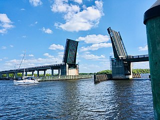
The Wilson Pigott Bridge is a small two-lane drawbridge located near Fort Myers Shores in Lee County, Florida. It is one of four drawbridges in Lee County. It is 27 feet tall.
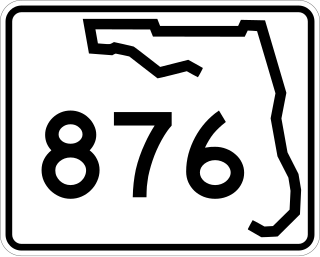
County Road 876 is a major county road in Lee County, Florida spanning 22.92 miles (36.89 km). It is major east-west thoroughfare just south of Fort Myers city limits before becoming a north-south route through Lehigh Acres and Buckingham. The east-west portion is locally known as Cypress Lake Drive west of U.S. Route 41 and Daniels Parkway east of there. The north-south segment is known as Gunnery Road through Lehigh Acres and Buckingham Road through Buckingham.


