State Road 994, locally known as Quail Roost Drive, is an 8.06-mile-long (12.97 km) east–west four-lane road in southern Miami-Dade County, Florida area. It connects Krome Avenue with U.S. Route 1.
The current State Road 579 is a 0.5-mile (0.80 km) stretch of Fletcher Avenue between Florida Avenue and Nebraska Avenue in Tampa, Florida. Similar to SR 678 to the north, it exists to connect US 41, Interstate 275, and Business US 41. Despite its odd-numbered Florida Department of Transportation designation, SR 579 is signed east–west.
State Road 874, named the Don Shula Expressway for its length, is an electronic toll road in southern Miami-Dade County, Florida. It extends 7 miles (11 km) northeast from the Homestead Extension of Florida's Turnpike (HEFT) in southwestern Kendall to the Palmetto Expressway in Glenvar Heights, allowing traffic from the far south of Miami-Dade County and the Florida Keys to move to more central regions of metropolitan Miami and vice versa, bypassing communities along U.S. Route 1, while also permitting local access to the Kendall district. The road, named in honor of the long-serving coach of the Miami Dolphins NFL team, is maintained and tolled by the Miami-Dade Expressway Authority (MDX). Contrary to the numbering plan of Florida State Roads, SR 874 is signed north–south.
State Road 878, named the Snapper Creek Expressway or the Snapper Creek Tollway for its entire length, is a 2.7-mile-long (4.3 km) east–west electronic toll road south of Miami, Florida. The expressway is named for the nearby Snapper Creek which runs parallel to SR 878. It acts as a spur route of the Don Shula Expressway, providing access to U.S. Route 1 near South Miami and local access to the eastern Kendall area while bypassing the Dadeland district. The road is maintained and tolled by the Miami-Dade Expressway Authority (MDX).
State Road 826 is a bypass route around the greater Miami area, traveling approximately 30 miles (48 km) in a northeasterly arc from U.S. Route 1 in Pinecrest to its terminus at State Road A1A in Sunny Isles Beach. Between its southern terminus and the Golden Glades Interchange, State Road 826 is known as the Palmetto Expressway, a heavily traveled freeway with portions of the road carrying in excess of 250,000 vehicles a day. Unlike many of the other expressways in Miami-Dade County, the Palmetto Expressway is untolled. East of the interchange, State Road 826 is a surface road connecting North Miami and North Miami Beach to Sunny Isles Beach over the Intracoastal Waterway.
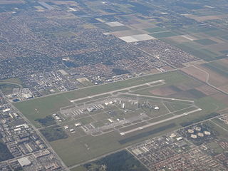
State Road 959, known locally as West 57th Avenue and Red Road, is a 5.381-mile-long (8.660 km) north-south Florida state highway located in south Miami-Dade County west of Downtown Miami. It runs from U.S. 1 at the south end at the South Miami-Coral Gables border to Perimeter Road just south of the runway of the Miami International Airport at its north end.
State Road 997, also known as Krome Avenue and West 177th Avenue is a 36.7-mile-long (59.1 km) north–south state highway in western Miami-Dade County, Florida. It runs from State Road 998 in Homestead north across U.S. Route 41 to U.S. Route 27 near Countyline Dragway, just south of the Broward County line. Its main use is as a bypass around the western side of Miami, linking the routes that run southwest, west and northwest from that city. The road passes through newer suburbs in the southern third of its length, while the northern two thirds of the highway traverse the eastern edge of the Everglades.
State Road 985, locally known as West 107th Avenue, FIU Avenue, and Avenue of the Americas, is a 7.604-mile (12.237 km) long north–south street in western Miami-Dade County, Florida, serving the communities of Kendall, University Park, Sweetwater, Fontainebleau, and Doral.
State Road 916, locally known as Northwest 138th Street, West 84th Street, North 135th Street, Opa-locka Boulevard, and Natural Bridge Road is a 10.253 miles (16.501 km) long east–west highway crossing northern Miami-Dade County, Florida. Its western terminus is at an interchange with Interstate 75, the Palmetto Expressway, and the Gratigny Parkway on the boundary between Hialeah and Miami Lakes, traveling east to Biscayne Boulevard.
State Road 969, locally known as Milam Dairy Road and West 72nd Avenue, is a 5.2-mile (8.4 km) long north–south street west of Miami International Airport in western Miami-Dade County, Florida. The southern terminus is currently an intersection with SR 968 in the city of Miami, and its northern terminus is an intersection with SR 934, just south of Medley.
State Road 933, locally known as West 12th Avenue, and Ronald W. Reagan Avenue, is a 4.25-mile (6.84 km) long north–south street entirely within the city limits of Miami, Florida. Its southern terminus is an intersection with Coral Way as Coral Way changes from Southwest 22nd Street to Southwest Third Avenue; its northern terminus is an interchange with the Airport Expressway. North of Dolphin Expressway, reassurance signage is virtually nonexistent, and the only indication of SR 933 existing north of Northwest 14th Street is a pair of trailblazer signs on Northwest 36th Street.
State Road 989, locally known as Allapattah Road and Southwest 112th Avenue, is a 3.0-mile-long (4.8 km) north–south four lane undivided highway in southern Miami-Dade County, Florida between the Homestead Air Reserve Base and Cutler Bay. SR 989 begins at an interchange with the Homestead Extension of Florida's Turnpike and ends at an intersection with the Dixie Highway.
Florida State Road 823 (SR 823) is a 20.6-mile (33.2 km) long state highway in the U.S. state of Florida. The road runs from U.S. Route 27 (SR 25) in Hialeah to Interstate 595 (SR 862) and SR 84 in Davie. The section in Miami-Dade County, through Hialeah and Miami Lakes, is known as Red Road. In Broward County, the road turns northwest and merges into Flamingo Road, until its terminus in Davie, though the road continues without designation into Sunrise.
Sunset Drive, also known as Southwest 72nd Street is a 12.5-mile-long (20.1 km) east–west arterial road traversing the southwestern suburbs of Miami, Florida, from the northwestern portions of the Kendall area to Coral Gables. A central portion of Sunset Drive is maintained by the Florida Department of Transportation as State Road 986, which runs from the Homestead Extension (HEFT) underpass to Southwest 69th Avenue and is signed through South Miami to US 1.

Red Road, also known as West 57th Avenue, is a 20.6-mile (33.2 km) main north-south street running west of downtown Miami in Miami-Dade County, Florida and into Broward County. Red Road is signed as State Road 959 from U.S. 1 to the south end of the Miami International Airport, and State Road 823 from U.S. 27 to the Broward County line.
Galloway Road, also known as West 87th Avenue, is a north-south route through the western areas of suburban Miami-Dade County, Florida, from the Black Point area south of Cutler Bay almost to the Broward County line north of Miami Lakes. It exists in seven different unconnected segments that total 27.5 miles (44.3 km) in length, acting as connecting roads, neighborhood streets, and arterial routes. Approximately 9.5 miles (15.3 km) of Galloway Road, between Pinecrest and Doral, is designated as State Road 973.
Kendall Drive, also known as Southwest 88th Street and historically North Kendall Drive, runs for 13.3 miles (21.4 km) in an east–west orientation across mid-southern Miami-Dade County, Florida. The majority of Kendall Drive, between State Road 997 at The Hammocks and US 1 on the Kendall–Pinecrest border, is signed as the 10.7-mile-long (17.2 km) State Road 94. The road serves as a major arterial road through the suburbs of the southern Miami metropolitan area, connecting its predominantly residential neighborhoods to shopping districts and to three freeways, allowing commuter travel.
Coral Reef Drive, also known as South 152nd Street, is a 9.6-mile-long (15.4 km) main east–west road south south of Miami in Miami-Dade County, Florida, United States. It serves to connect the communities of Country Walk and Richmond Heights with Palmetto Bay. State Road 992 is designated along the 2.462-mile-long (3.962 km) section of Coral Reef Drive between the Homestead Extension of Florida's Turnpike and US 1.
State Road 960, locally known as Northwest 14th Street, is a 0.671-mile-long (1.080 km) east–west street adjacent to Miami International Airport in western Miami-Dade County, Florida. The easternmost segment between the route's eastern terminus and Northwest 37th Avenue is one way westbound. The road runs parallel to the Dolphin Expressway. The designation was created in 2014 as part of a jurisdictional swap over various roadways between the Florida Department of Transportation (FDOT) and the City of Miami.