Fly, Tennessee | |
|---|---|
 Fly Cemetery | |
 Fly, Tennessee  Fly, Tennessee | |
| Coordinates: 35°47′22″N87°9′31″W / 35.78944°N 87.15861°W | |
| Country | United States |
| State | Tennessee |
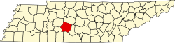
| County | Maury |
| Elevation | 650 ft (200 m) |
| Time zone | UTC-6 (Central (CST)) |
| • Summer (DST) | UTC-5 (CDT) |
| ZIP code | 38482 |
| Area code | 931 |
| GNIS feature ID | 1284532 [1] |
Fly is an unincorporated community in Maury County, Tennessee. It is along the Natchez Trace Parkway, south of Nashville. [2] The small valley known as Fly Hollow is between Fly and the Natchez Trace. [3]
In the early 19th century a number of Fly family members, mostly from North Carolina, moved to this part of Tennessee near the Natchez Trace on Leipers Creek, a tributary of the Duck River. After a rail line was built through the area the settlement was called Fly's Station. The local store is still called Fly's Store. [4]