
Millard County is a county in the U.S. state of Utah. As of the 2020 United States Census, the population was 12,975. Its county seat is Fillmore, and the largest city is Delta.

Kings Peak is the highest peak in the U.S. state of Utah, with an elevation of 13,528 feet (4,123 m) NAVD 88.

The Northern and Central Bitterroot Range, collectively the Bitterroot Mountains, is the largest portion of the Bitterroot Range, part of the Rocky Mountains and Idaho Batholith, located in the panhandle of Idaho and westernmost Montana in the northwestern United States. The mountains encompass an area of 4,862 square miles (12,593 km2).

Mount Nebo is the southernmost and highest mountain in the Wasatch Range of Utah, in the United States, and the centerpiece of the Mount Nebo Wilderness, inside the Uinta National Forest. It is named after the biblical Mount Nebo in Jordan, overlooking Israel from the east of the Jordan River, which is said to be the place of Moses' death.

Uncompahgre Peak is the sixth highest summit of the Rocky Mountains of North America and the U.S. state of Colorado. The prominent 14,316-foot (4363.46 m) fourteener is the highest summit of the San Juan Mountains and the highest point in the drainage basin of the Colorado River and the Gulf of California. It is located in the Uncompahgre Wilderness in the northern San Juans, in northern Hinsdale County approximately 7 miles (11 km) west of the town of Lake City.

Mount Antero, historically called Antero Peak, is the highest summit of the southern Sawatch Range of the Rocky Mountains of North America. The prominent 14,269-foot (4349.21 m) fourteener is located in San Isabel National Forest, 12.2 miles (19.6 km) southwest by south of the Town of Buena Vista in Chaffee County, Colorado, United States. The mountain is named in honor of Chief Antero of the Uintah band of the Ute people.

Delano Peak is a mountain in the Tushar Mountains in the Fishlake National Forest in Beaver and Piute counties in Utah, United States.

The Snake Range is a mountain range in White Pine County, Nevada, United States. The south-central portion of the range is included within Great Basin National Park, with most of the remainder included within the Humboldt-Toiyabe National Forest. The range reaches a maximum elevation of 13,065 feet (3,982 m) at the summit of Wheeler Peak, the tallest independent mountain within Nevada and the second highest point within the state. The range also contains four of the five highest mountain peaks in Nevada, including all peaks greater than 12,000 feet (3,658 m) except for Boundary Peak.

Deseret Peak is the highest peak in the Stansbury Mountains with an elevation of 11,035 ft. It is located in the Deseret Peak Wilderness area west of Grantsville, Utah and east of Skull Valley Indian Reservation. It is the fourth most topographically prominent peak in the state of Utah. The site is a popular destination for hikers and backcountry skiers as the area is a contrast of the alpine wilderness with the surrounding desert basin. The trail that leads to the peak is easily accessible from Salt Lake City. The mountain offers views of the Bonneville Salt Flats, the Great Salt Lake, and the surrounding towns and mountain ranges. On a clear day, it is possible to see Mount Nebo, the highest peak in the adjacent Wasatch Mountains.

Mount Holmes is a prominent mountain peak in Yellowstone National Park. It is the tallest mountain in the Wyoming portion of the Gallatin Range. Mount Holmes is located in the northwestern part of the park and marks the southern terminus of the Gallatin Range. It is the source of Indian Creek, a tributary of the Gardner River.
The Goose Creek Mountains are a mountain range in Box Elder County, Utah. They are also partly in Elko County, Nevada. It is the least topographically prominent of Utah's peaks with more than 609.6 ft (2000 ft) of prominence.

Sacajawea Peak is a peak in the Wallowa Mountains, in the U.S. state of Oregon. It is in the Eagle Cap Wilderness and the Wallowa–Whitman National Forest.

Bannock Peak is a 10,329-foot (3,148-metre) mountain summit in the southern section of the Gallatin Range in Yellowstone National Park, in the U.S. state of Wyoming. The peak ranks as the sixth-highest peak in the Gallatin Range. Precipitation runoff from the mountain drains west into headwaters of the Gallatin River and east into Panther Creek which is a tributary of the Gardner River. Topographic relief is significant as the summit rises nearly 2,000 feet above Panther Creek in one mile (1.6 km). This mountain's toponym was officially adopted in 1897 by the United States Board on Geographic Names.
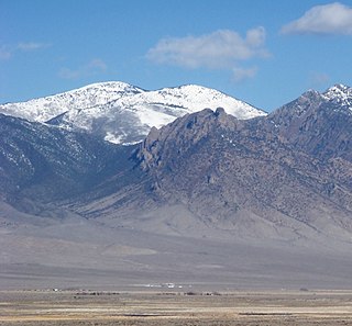
Ibapah Peak is a 12,087-foot (3,684 m) summit in Juab County, Utah in the United States. It is the highest point of the Deep Creek Range and is located less than 5 miles (8.0 km) east of the Utah-Nevada border, and about 10 miles (16 km) northwest of the town of Trout Creek, Utah. With a topographic prominence of 5,247 feet (1,599 m) it is the eighth-most prominent summit in Utah.

Dead Horse Peak is a 12,642-foot elevation (3,853 m) mountain summit located on the common border that Duchesne County shares with Summit County in the U.S. state of Utah.

Grandview Peak is a 9,410-foot-elevation (2,868-meter) mountain summit located in Salt Lake County, Utah, United States.
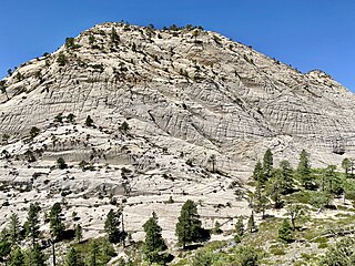
Northgate Peaks are two summits in Washington County, Utah, United States.


