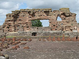
Viroconium or Uriconium, formally Viroconium Cornoviorum, was a Roman town, one corner of which is now occupied by Wroxeter, a small village in Shropshire, England, about 5 miles (8.0 km) east-south-east of Shrewsbury. At its peak, Viroconium is estimated to have been the 4th-largest Roman settlement in Britain, a civitas with a population of more than 15,000. The settlement probably lasted until the end of the 7th century or the beginning of the 8th. Extensive remains can still be seen.
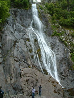
Abergwyngregyn is a village and community of historical note in Gwynedd, a county and principal area in Wales. Under its historic name of Aber Garth Celyn it was the seat of Llywelyn ap Gruffudd. It lies in the historic county of Caernarfonshire.

Trecastle is a village in Powys, Wales, on the edge of the Brecon Beacons National Park, and in the community of Llywel.

Pen Dinas is the name of a large hill within the boundary of the village of Penparcau, on the coast of Ceredigion, Wales, upon which an extensive Iron Age, Celtic hillfort of international significance is situated.
The Limes Arabicus was a desert frontier of the Roman Empire, mostly in the province of Arabia Petraea. It ran northeast from the Gulf of Aqaba for about 1,500 kilometers (930 mi) at its greatest extent, reaching northern Syria and forming part of the wider Roman limes system. It had several forts and watchtowers.
Geraint Dyfed Barri Jones was a classical scholar and archaeologist.
Maesglas is a neighbourhood in the south west of the city of Newport, South Wales. In the 16th century it was known as Greenfield but in later years the Welsh language Maesglas has come to be more widely used.

Rhosesmor is a small village near Mold, Flintshire, in north-east Wales. The village lies near the parishes of Halkyn and Rhes-y-cae. The hamlet of Wern-y-Gaer is encompassed by the boundaries of the village.

Westerwood is an area in the north-east of Cumbernauld in North Lanarkshire, Scotland. Historically it was the site of a Roman Fort of which a video reconstruction has been produced. In the past two decades, new housing developments have been built around the Westerwood Hotel and Golf Course. The golf complex is owned by Aprirose since they acquired QHotels in October 2017. The hotel's internationally award winning spa cost more than half a million pounds. In October 2018, after a 1.3 million pound refurbishment, the resort re-opened as DoubleTree by Hilton Glasgow Westerwood Spa and Golf Resort in a franchise agreement between Aprirose and Hilton Hotels. The golf course, which was designed by Seve Ballesteros and Dave Thomas, is located on the north side of the town, close to Cumbernauld Airport. Westerwood Community Council was set up for local residents and a committee has been appointed. Neighbouring villages which are outside of Cumbernauld include Dullatur to the north-west and Castlecary to the east.

The Caersws Roman Forts are two Roman military camps at Caersws, Powys in Mid Wales. They were garrisoned during the occupation of Great Britain between the 1st and 5th centuries when this part of Wales was part of the Roman province of Britannia Superior. A surviving section of Roman Road lies to the west of the encampments.

Wolvesnewton is a small village in the community of Devauden, Monmouthshire, south east Wales, United Kingdom. It is located 6 miles (9.7 km) north west of Chepstow between the villages of Devauden and Llangwm.

Y Gaer is a Roman fort situated near modern-day Brecon in Mid Wales, United Kingdom. Y Gaer is located at grid reference SO00332966.

The Cambrian Archaeological Association was founded in 1846 to examine, preserve and illustrate the ancient monuments and remains of the history, language, manners, customs, arts and industries of Wales and the Welsh Marches and to educate the public in such matters. The association's activities include sponsoring lectures, field visits, and study tours; as well as publishing its journal, Archaeologia Cambrensis, and monographs. It also provides grants to support research and publications.

Mynydd Illtud is an extensive area of common land near Libanus, Powys, Wales, located in the Brecon Beacons National Park and some three miles south-west of Brecon. The common is an undulating plateau lying between 330 and 370 metres above sea level. Its highest points are 381 metres (1,250 ft) at Allt Lom and 367 metres (1,204 ft) at Twyn y Gaer trig point overlooking the valley of the River Usk. Twyn y Gaer is the site of an Iron Age hill fort.

Y Garn Goch is a hill in the Brecon Beacons National Park in the east of Carmarthenshire, Wales. The name means the 'red cairn'. It lies near the village of Bethlehem, three miles southwest of Llangadog and four miles east of Llandeilo on the southern side of the broad Towy Valley. It is also commonly known as either Garn Goch or Carn Goch. Current landowners are the Brecon Beacons National Park Authority.

Long Mountain is a hill located east of Welshpool in Powys, Wales. It crosses the national boundaries of England and Wales, and also the county boundaries of Powys and Shropshire.
The Gaer House is an estate house located in the community of Gaer, Newport, Monmouthshire, South Wales. It is situated about 2 miles (3.2 km) from the Newport to Cardiff road, near a Roman fort, which gave the name to the estate. The Gaer Hillfort, a large circular site, is a huge fort situated in a defensive position overlooking the Ebbw River. It contains many enclosures, a large bank and a ditch. In the 17th century, the hillfort was included in the ornamental landscaping plan of nearby Tredegar House.

Nantcribba is a township in the parish of Forden in the historic county of Montgomeryshire and now in Powys It is also the site of Nantcribba Castle which was built by the Corbett, Barons of Caus, of Caus Castle in Shropshire. To the south of the Castle site was Nantcribba Hall, which was owned by the Devereux family and the Marquises of Hereford. In the 19th century Nantcribba became part of the Leighton Hall estates.

Parciau hill fort is a hill fort on the Welsh island of Anglesey. It stands on the summit of Bryn Ddiôl, whose name means "trackless hill".


