Forden

Last updated

Forden
St Michaels, Forden - geograph.org.uk - 1163084.jpg
St Michaels, Forden
Powys UK location map.svg
Red pog.svg
Forden
Location within Powys
Population1,426 (2011) [1]
OS grid reference SJ227010
Community
  • Forden with Leighton and Trelystan
Principal area
Ceremonial county
Country Wales
Sovereign state United Kingdom
Post town WELSHPOOL
Postcode district SY21
Dialling code 01938
Police Dyfed-Powys
Fire Mid and West Wales
Ambulance Welsh
UK Parliament
Senedd Cymru – Welsh Parliament
List of places
UK
Wales
Powys
52°36′07″N3°08′35″W / 52.602°N 3.143°W / 52.602; -3.143 Coordinates: 52°36′07″N3°08′35″W / 52.602°N 3.143°W / 52.602; -3.143

Forden (Welsh : Ffordun) is a village near Welshpool in Powys, Wales, formerly in the historic county of Montgomeryshire. It forms part of the community (and community council) of Forden, Leighton and Trelystan with the neighbouring settlements of Trelystan, Leighton and Kingswood.

Contents

Looking down on the parish is the Long Mountain, which stretches north eastwards from Forden through the border between Montgomeryshire and Shropshire, England.

History

Traces of a Roman road and of a Roman camp called locally "the Gaer" are near the River Severn, in a township of the parish called Thornbury. [2]

In 1868, the National Gazetteer said of the parish

FORDEN, a parish in the hundred of Cawrse, county Montgomery, North Wales, 3 miles N. of Montgomery, and 4 S.E. of Welshpool, its post town. The Oswestry and Newtown railway has a station at each of these towns. Forden is situated on the eastern bank of the river Severn, near Offa's Dyke, and includes the townships of Hem, Kilkewyd, and several others. The Welsh suffered defeat here in the reign of Edward I. The living is a perpetual curacy in the diocese of Hereford, value £112, in the patronage of the Grocers' Company. The church is dedicated to St Michael. It contains monuments of the Devereux family. There are a few charities, producing about £4 per annum. There is a National school. The principal building in the parish is the House of Industry for the district of Montgomery and Pool. In the neighbourhood are remains of entrenched camps. [3]

The parish church of St Michael and All Angels, about half a mile to the west of the road from Welshpool to Montgomery, was enlarged in 1830. For some three hundred years the church was the burial-place of the family of Devereux, whose estate at Nantcribba was within the parish. The marble font, oval in shape, was presented in 1794 by Richard Edmunds. [2]

Between 1861 and 1965 the village was served by Forden railway station on the Cambrian Coast Line.

Captain Stephen Beattie VC (1908–1975), a Welsh recipient of the Victoria Cross was born at Leighton, Montgomeryshire.

Governance

A rural district of Forden was created by the Local Government Act 1894 and survived until 1974. All significant local government services are now provided by the Powys County Council unitary authority. There is also a Forden with Leighton and Trelystan community council, which has a mostly consultative role.

Until 2022 Forden was the name of the electoral ward, coterminous with the Forden with Leighton and Trelystan community. The ward was represented on Powys County Council by one county councillor, who was an Independent since 1995, with the exception of 2004-2008 when a Liberal Democrat candidate was adopted. Generally a single candidate stood, with no election necessary. [4] Following a boundary review, in 2022 the Forden and Montgomery wards merged to become 'Forden and Montgomery'. Green Party candidate, Jeremy Thorp, won the seat at the 2022 Powys Council election. [5]

For the purposes of the Senedd, Forden is part of the Montgomeryshire constituency and the Mid and West Wales electoral region. The parish forms part of the Montgomeryshire parliamentary constituency in the House of Commons of the UK Parliament.

Remains of the station which closed in 1965 Forden station (remains) geograph-3523193-by-Ben-Brooksbank.jpg
Remains of the station which closed in 1965

Sport

The village is represented by Forden United who play at the community centre.

Related Research Articles

<span class="mw-page-title-main">Montgomeryshire</span> Historic county of Wales

Montgomeryshire is one of thirteen historic counties and a former administrative county of Wales. It is named after its county town, Montgomery, which in turn is named after one of William the Conqueror's main counsellors, Roger de Montgomerie, who was the 1st Earl of Shrewsbury.

<span class="mw-page-title-main">Welshpool</span> Town in Wales

Welshpool is a market town and community in Powys, Wales, historically in the county of Montgomeryshire. The town is four miles from the Wales–England border and low-lying on the River Severn; its Welsh language name Y Trallwng means "the marshy or sinking land". The community includes Cloddiau and Pool Quay.

<span class="mw-page-title-main">Llanrhaeadr-ym-Mochnant</span> Human settlement in Wales

Llanrhaeadr-ym-Mochnant is a village, community and an ecclesiastical parish in the extreme north of Powys, Wales; about 9 miles west of Oswestry and 12 miles south of Llangollen, on the B4580. It lies near the foothills of the Berwyn mountains on the river Rhaeadr. At the top end of the valley is the Pistyll Rhaeadr waterfall, one of the Seven Wonders of Wales in the old rhyme. One mile north of the town is the hill Moel Hen-fache. The community includes the hamlet of Llanarmon Mynydd Mawr.

<span class="mw-page-title-main">Montgomery, Powys</span> Town in Powys, Wales

Montgomery is a town and community in Powys, Wales. It is the traditional county town of the historic county of Montgomeryshire to which it gives its name and is within the Welsh Marches border area. The town centre lies about 1 mile (1.6 km) west of the England–Wales border. Montgomery Castle was started in 1223 and its parish church in 1227. Other locations in the town include The Old Bell Museum, the Offa's Dyke Path, the Robber's Grave and the town wall. The large Iron Age hill fort of Ffridd Faldwyn is sited northwest of the town and west of the Castle.

<span class="mw-page-title-main">Llanfair Caereinion</span> Market Town in Wales

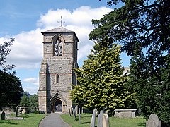
Llanfair Caereinion is a market town and community in Montgomeryshire, Powys, Wales upon the River Banwy, around 8 miles west of Welshpool. In 2011 the ward had a population of 1,810; the town itself had a population of 1,055 according to Nomis.

<span class="mw-page-title-main">Montgomeryshire (UK Parliament constituency)</span> Parliamentary constituency in the United Kingdom

Montgomeryshire is a constituency in Wales represented in the House of Commons of the UK Parliament.

Berriew is a village and community in Montgomeryshire, Powys, Wales. It is on the Montgomeryshire Canal and the Afon Rhiw, near the confluence with the River Severn at grid reference SJ185005, 79 miles (128 km) from Cardiff and 151 miles (243 km) from London. The village itself had a population of 283. and the community also includes Garthmyl Hall and Refail.

<span class="mw-page-title-main">District of Montgomeryshire</span> Former district of Powys, Wales

The District of Montgomeryshire or Montgomery was one of three local government districts of the county of Powys, Wales, from 1974 until 1996. The district had an identical area to the previous administrative county of Montgomeryshire. The district was abolished in 1996, with Powys County Council taking over its functions.

<span class="mw-page-title-main">Llanwddyn</span> Human settlement in Wales

Llanwddyn is a village and community in Montgomeryshire, Powys, Wales. The community is centred on the Lake Vyrnwy reservoir. The original Llanwddyn village, about 2 miles (3.2 km) northwest, was submerged when the reservoir was created in the 1880s.

Trewern is a small village, community and electoral ward in Montgomeryshire, Powys, Wales. The community includes the villages of Buttington and Middletown, situated 4.5 miles (7.2 km) northeast of Welshpool, 14.5 miles (23.3 km) west of Shrewsbury and 1 mile (1.6 km) west of the Wales-England border.

Llandyssil is a village in Powys, Wales, about two miles from the town of Montgomery.

<span class="mw-page-title-main">Llanmerewig</span> Human settlement in Wales

Llanmerewig is a historic parish in Powys, Wales, in the historic county of Montgomeryshire, and is situated between Newtown and Welshpool. The church and small village stand on high ground, which overlooks the river Severn, and is close to Abermule; part of which lies within the parish. The river Severn forms the North Western boundary of the parish and the Eastern boundary is the river Mule, which cuts through a steep gorge, before entering the Severn at Abermule. The historic parish covered 1,023 acres.

Nantcribba is a township in the parish of Forden in the historic county of Montgomeryshire and now in Powys It is also the site of Nantcribba Castle which was built by the Corbett, Barons of Caus, of Caus Castle in Shropshire. To the south of the Castle site was Nantcribba Hall, which was owned by the Devereux family and the Marquises of Hereford. In the 19th century Nantcribba became part of the Leighton Hall estates.

Forden Gaer, Y Gaer, Caer Flos and Lavrobrinta are respective English, Welsh and possible Latin names for the Roman fort in the township of Thornbury, in the parish of Forden, in the old county of Montgomeryshire, which now forms part of Powys, Wales. The fort lies on the E bank of the Severn a short distance N of Montgomery, and covers an important crossing of the river close to the historic ford at Rhydywhyman. It is likely that this is the same fort as Lavrobrinta, which is mentioned in the Ravenna Cosmography. The fort lies on the Roman Road between Wroxeter and Caersws. The defences were originally of earth, subsequently revetted with a timber-laced rampart of clay. Some internal buildings may have been of stone. The fort was established ca. A.D. 75-80 and was not finally abandoned before the reign of Valentinian I. The finds are in the Powysland Museum, Welshpool.

<span class="mw-page-title-main">Llanfihangel-yng-Ngwynfa</span> Human settlement in Wales

Llanfihangel-yng-Ngwynfa was a parish within the former historic county of Montgomeryshire. It now forms a major part of the community of Llanfihangel in Powys, which covers an area of 5,366 hectares (20.72 sq mi). Its Community Council extends to take in Dolanog and Llwydiarth, having approximately 413 registered voters. The parish originally consisted of the following townships: Cefncleisiog, Cydwnfa, Dolwar, Fachwen, Farchwell, Fynnonarthwr, Garthucha, Halfen, Llaethbwlch, Llwydiarth, Nanty-Candy, and Rhiewlas. Dolanog seceded from Llanfihangel in 1856.

Mochdre is a small village and larger community in Montgomeryshire, Powys, Wales. The community includes Penstrowed and the much larger settlement of Stepaside. The community had a population of 494 as of the 2011 UK Census.

<span class="mw-page-title-main">Llanwddyn (electoral ward)</span>

Llanwddyn was the name of an electoral wards in the far north of Powys, Wales. It covered the community of Llanwddyn as well as the neighbouring communities of Llangynog and Pen-y-Bont-Fawr. The ward elected a county councillor to Powys County Council.

<span class="mw-page-title-main">Newtown and Llanllwchaiarn</span>

Newtown and Llanllwchaiarn is a local government community in mid Powys, Wales. It includes the town of Newtown and the small neighbouring village of Llanllwchaiarn. At the time of the 2011 census the population of the community was 11,357. The community council is called Newtown and Llanllwchaiarn Town Council, often abbreviated to Newtown Town Council.

Forden United Football Club is a Welsh football team based in Forden, a village near Welshpool in Powys, Wales. The team currently play in the Mid Wales Football League East DivisionCentral Wales League Northern Division, which is at the fourth tier of the Welsh football league system.

References

  1. "Ward/Community population 2011". Neighbourhood Statistics. Office for National Statistics. Retrieved 11 November 2015.
  2. 1 2 'Forden', in Samuel Lewis, A Topographical Dictionary of Wales (1833)
  3. Forden at genuki.org.uk
  4. "Powys 1995-2012" (PDF). The Elections Centre. Retrieved 22 January 2018.
  5. "County Council Elections 2022 - Montgomeryshire". Powys Council. Retrieved 10 May 2022.The councillor is not to be confused with Liberal Party leader Jeremy Thorpe.